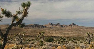
San Bernardino County, officially the County of San Bernardino, is a county located in the southern portion of the U.S. state of California, and is located within the Inland Empire area. As of the 2020 U.S. Census, the population was 2,181,654, making it the fifth-most populous county in California and the 14th-most populous in the United States. The county seat is San Bernardino.

The Mojave River is an intermittent river in the eastern San Bernardino Mountains and the Mojave Desert in San Bernardino County, California, United States. Most of its flow is underground, while its surface channels remain dry most of the time, except for the headwaters and several bedrock gorges in the lower reaches.

The San Bernardino Mountains are a high and rugged mountain range in Southern California in the United States. Situated north and northeast of San Bernardino and spanning two California counties, the range tops out at 11,503 feet (3,506 m) at San Gorgonio Mountain – the tallest peak in all of Southern California. The San Bernardinos form a significant region of wilderness and are popular for hiking and skiing.

The San Jacinto Mountains are a mountain range in Riverside County, located east of Los Angeles in southern California in the United States. The mountains are named for one of the first Black Friars, Saint Hyacinth, who is a popular patron in Latin America.

The Dead Mountains are a mountain range in the southeastern Mojave Desert, in San Bernardino County, California. The range borders the tri-state intersection of Nevada, Arizona and California, and the Mohave Valley, with the Fort Mojave Indian Reservation bordering the range foothills on the east and northeast, in the three states.
Oro Grande is an unincorporated community in the Mojave Desert of San Bernardino County, California, United States. It lies on the city boundary of Victorville and Adelanto. It is at 3,000 feet (910 m) elevation in Victor Valley north of the San Bernardino mountain range. It is located on old Route 66 near Interstate 15 between Victorville and Barstow. The ZIP code is 92368 and the community is inside area codes 442 and 760. Less than 1,000 residents live in the unincorporated area.

The Sheep Hole Mountains are a mountain range in the Mojave Desert, to the north of Joshua Tree National Park, in San Bernardino County, California. The mountains were once Chemehuevi hunting grounds.
The Clipper Mountains are located in the eastern Mojave Desert and protected within Mojave Trails National Monument, in San Bernardino County, California.
The Piute Mountains are a mountain range located in the Eastern Mojave Desert and within Mojave Trails National Monument, in San Bernardino County, California.

The Bigelow Cholla Garden Wilderness is in the eastern Mojave Desert and within Mojave Trails National Monument, located in San Bernardino County, California.

The Morongo Basin is an endorheic basin and valley region located in eastern San Bernardino County, in Southern California.
The Bighorn Mountains are a mountain range of the Mojave Desert and Transverse Ranges, located in San Bernardino County, California. They are primarily within a Bureau of Land Management (BLM) protected area.
The Calumet Mountains are a mountain range in San Bernardino County, California. They are north of Joshua Tree National Park and adjacent to the Sheep Hole Mountains in the Mojave Desert. The highest point is 829 meters.

The Clipper Mountain Wilderness is a wilderness area in the Clipper Mountains of the eastern Mojave Desert and within Mojave Trails National Monument, located in northeastern San Bernardino County, California. It is under the jurisdiction of the Bureau of Land Management.

Bristolia is an extinct genus of trilobite, fossil marine arthropods, with eight or more small to average size species. It is common in and limited to the Lower Cambrian shelf deposits across the southwestern US, which constitutes part of the former paleocontinent of Laurentia.
The Wildlands Conservancy (TWC) is a nonprofit organization whose mission is to preserve land for public recreation. It operates 23 preserves in California and Oregon. The preserve system comprises 210,686 acres including mountains, valleys, deserts, rivers and oceanfront lands. TWC buys land, restores land, builds public visitor facilities and provides outdoor education programs for children. All usage is free of charge. There are over 1 million visitors annually.

Castle Mountains National Monument is a U.S. National Monument located in the eastern Mojave Desert and northeastern San Bernardino County, in the state of California.

Mojave Trails National Monument is a large U.S. National Monument located in the state of California between Interstates 15 and 40. It partially surrounds the Mojave National Preserve. It was designated by President Barack Obama on February 12, 2016, along with Castle Mountains National Monument and Sand to Snow National Monument, also in southern California. It is under the administration of the Bureau of Land Management.

Sand to Snow National Monument is a U.S. National Monument located in San Bernardino County and northern Riverside County, Southern California.
Cadiz Dunes Wilderness is a protected wilderness area in the Mojave Trails National Monument in San Bernardino County, California. Established in 1994 by the U.S. Congress, the area is managed by the Bureau of Land Management. This wilderness area is north of Joshua Tree National Park, Sheephole Valley Wilderness lies to the west, Old Woman Mountains Wilderness to the east. The dunes of Cadiz Dunes were formed by blowing sands from the Cadiz dry lake, all located in the Cadiz Valley between the Calumet Mountains and the Old Woman Mountains. The ecology is typical of the Mojave Desert with wildlife that includes coyote, black-tailed jackrabbits, ground squirrels, kangaroo rats, quail, roadrunners, and rattlesnakes. The area is known for a brilliant display of springtime desert wildflowers including the Borrego milkvetch.


