A park is an area of natural, semi-natural or planted space set aside for human enjoyment and recreation or for the protection of wildlife or natural habitats. Urban parks are green spaces set aside for recreation inside towns and cities. National parks and Country parks are green spaces used for recreation in the countryside. State parks and Provincial parks are administered by sub-national government states and agencies. Parks may consist of grassy areas, rocks, soil and trees, but may also contain buildings and other artifacts such as monuments, fountains or playground structures. Many parks have fields for playing sports such as soccer, baseball and football, and paved areas for games such as basketball. Many parks have trails for walking, biking and other activities. Some parks are built adjacent to bodies of water or watercourses and may comprise a beach or boat dock area. Urban parks often have benches for sitting and may contain picnic tables and barbecue grills.
Bromborough is a town within the Metropolitan Borough of Wirral, in Merseyside. Originally in Cheshire, it is situated on the Wirral Peninsula, to the south of Bebington and to the north of Eastham. In the 2001 Census, the population of the township was 12,630, But the total number of people in the larger Bromborough Ward was 13,963. By the time of the 2011 Census the population of the township was no longer collected although that of the Ward was shown as having increased to 14,850.
Wirral, also known as The Wirral, is a peninsula in North West England. The Metropolitan Borough of Wirral is part of the Liverpool City Region. It is bounded to the west by the River Dee, forming a boundary with Wales, to the east by the River Mersey, and to the north by the Irish Sea.
Marfords Park comprises 19,000 square metres (1.9 hectares; 4.7 acres) and consists of a small playground area (designed for children under 12) and a larger grassed area.[citation needed] It is popular with young families and dog-walkers. The park is almost entirely bounded by residential properties in Marfords Avenue, Cunningham Drive and Granville Crescent, with pedestrian access from Marfords Avenue and Cunningham Drive.
Marfords Park is located within the Marfords Park Neighbourhood which has a Residents Association, the Marfords Park Neighbourhood Residents Association, which serves to represent the view of residents living within the Marfords Park Neighbourhood, bounded by Allport Road, the Wirral Line railway, Dibbinsdale Road and the Marfords Wood element of Brotherton Park and Dibbinsdale Local Nature Reserve (owned by the Lancelyn-Green family whose ancestral home has been Poulton Hall since 1093).[citation needed]
Poulton Hall is a country house in Poulton Road, Poulton, an area to the south of Bebington, Wirral, Merseyside, England. The present hall was built in 1653 and was extended in the following centuries. It is built in pebbledashed brick with stone dressings and slate roof. Its contents include a three-manual pipe organ. In the grounds is a 17th-century former brewhouse that has a clock tower with a 32-bell carillon. The house and the brewhouse are both recorded in the National Heritage List for England as designated Grade II listed buildings. Musical concerts are held in the house, and the gardens, which contain 20th-century sculptures, are open to the public twice a year.
Marfords Park, as much of the residential land in Poulton and Dibbinsdale area, occupies land formerly owned by the Lancelyn-Greens. However, in the case of Marfords Park the land was not sold by the Lancelyn-Greens but donated with a deed of covenant restricting its future use by Cheshire County Council.
Cheshire County Council was the county council of Cheshire. Founded on 1 April 1889, it was officially dissolved on 31 March 2009, when it and its districts were superseded by two unitary authorities; Cheshire West and Chester and Cheshire East.
Etymology
Marford means ford at the boundary and so Marfords refers to the crossings of the River Dibbin (one of which remains as Dibbinsdale Bridge) although originally the crossings would have literally been fords.[1] Marfords Park is within the Clatterbridge Ward of the Wirral Council, the Clatter brook being a tributary to the River Dibbin.[2]
Notes and references
↑ The name is English in origin, and may mean either the "ford of the mere", or refer to "mere" in its alternative sense of "boundary" — Palmer, A. N. A History of Ancient Tenures of Land in North Wales..., 1910, p.128.
A geographic coordinate system is a coordinate system that enables every location on Earth to be specified by a set of numbers, letters or symbols. The coordinates are often chosen such that one of the numbers represents a vertical position and two or three of the numbers represent a horizontal position; alternatively, a geographic position may be expressed in a combined three-dimensional Cartesian vector. A common choice of coordinates is latitude, longitude and elevation. To specify a location on a plane requires a map projection.
This page is based on this Wikipedia article Text is available under the CC BY-SA 4.0 license; additional terms may apply. Images, videos and audio are available under their respective licenses.
Related Research Articles
Bebington is a small town and electoral ward within the Metropolitan Borough of Wirral, in Merseyside, England. Historically part of Cheshire, it lies 5 miles (8 km) south of Liverpool, close to the River Mersey on the eastern side of the Wirral Peninsula. Nearby towns include Birkenhead and Wallasey to the north-northwest, and Heswall to the west-southwest. Bebington railway station opened in 1838 and is situated on the Wirral Line of the Merseyrail network.
Spital is a suburban area of the Metropolitan Borough of Wirral, in Merseyside, England. It is located mid-way on the Wirral Peninsula, and is mostly incorporated into the town of Bebington and the most westerly point of Spital forms the most northern edge of Bromborough.
Brotherton Park and Dibbinsdale Local Nature Reserve informally known as Dibbinsdale is a combined park and local nature reserve managed by the Metropolitan Borough of Wirral and located in Bromborough, Merseyside, England.
Raby is a hamlet located within the Metropolitan Borough of Wirral, Merseyside, England. It is located at the south-central part of the Wirral Peninsula, within the Clatterbridge Ward in the parliamentary constituency of Wirral South. At the time of the United Kingdom Census 2001, Raby had a total population of 100.
Tuxedo Park is a residential neighbourhood in the north-east quadrant of Calgary, Alberta. The inner city community is bounded to the north by 32 Avenue N, by Edmonton Trail to the east, the Trans-Canada Highway to the south and 2 Street NW to the west. The community is bisected by Centre Street from north to south.
Rosemont is a residential neighbourhood in the north-west quadrant of Calgary, Alberta. It is bounded by Northmount Drive to the north, by Cambrian Drive to the east, by 23 Avenue N and the Confederation Park to the south and by 14 Street W to the west.
Elboya is a residential neighbourhood in the southwest quadrant of Calgary, Alberta. It is bounded by the Elbow River to the north, 4th Street SW / 45 Avenue SW / Macleod Trail to the east, 50 Avenue S to the south and Elbow Drive to the west. Stanley Park borders the community to the northeast.
Christie Park is a residential neighbourhood in the southwest quadrant of Calgary, Alberta. It is bounded by Strathcona Drive and the community of Strathcona Park to the north, Sarcee Trail to the east, 17 Avenue S to the south and 69 Street W to the west.
Douglasdale is a residential neighbourhood in the south-east quadrant of Calgary, Alberta. It is bounded by 114 Avenue S to the north, 130 Avenue S to the south, Deerfoot Trail to the east and the Bow River to the west. The Fish Creek Provincial Park borders the neighbourhood to the west. Douglasglen is located in the northern area, north of Deerfoot Trail.
Roxboro is an inner city residential neighbourhood in the southwest quadrant of Calgary, Alberta, Canada. It is bounded to the north and west by the Elbow River and to the south by 33 Avenue SW of Roxboro, in a bend of the Elbow River, lies the community of Rideau Park.
North Glenmore Park is a residential neighbourhood in the southwest quadrant of Calgary, Alberta. It is bounded by 50 Avenue SW to the north, Glenmore Athletic Park, Lakeview Golf Course and Earl Grey Golf Club to the east, Earl Grey Golf Club to the south and Crowchild Trail SW to the west.
Highland Park is a residential neighbourhood in the north-west quadrant of Calgary, Alberta. It is bounded to the north by McKnight Boulevard, to the east by Edmonton Trail, to the south by 32 Avenue N and to the west by 4 Street W. Confederation Park and Nose Hill Park are located in close proximity. The Queens Park Cemetery occupies the south-western corner of the neighbourhood, and the Highland golf course is developed in the north.
Kelvin Grove is a residential neighbourhood in the southwest quadrant of Calgary, Alberta. It is bounded to the north by Glenmore Trail, to the east by Elbow Drive, to the south by 75 Avenue S and to the west by 14 Street W. The Rockyview General Hospital is located immediately west of the community.
Rosscarrock is a residential neighbourhood in the southwest quadrant of Calgary, Alberta. It is bounded to the north by Bow Trail to the east by 33 Street W, to the south by 17 Avenue S and to the west by 45 Street W. The Westbrook Mall is located in the northeast corner of the neighbourhood, and it is bordered by the Shaganappi golf course.
Huntington Hills is a residential neighbourhood in the north-west and north-east quadrant of Calgary, Alberta. It is bounded to the north by Beddington Boulevard, to the east by Deerfoot Trail and the Nose Creek, to the south by 64 Avenue N and to the west by the Nose Hill Park and 14 Street W. Centre Street runs through the neighbourhood.
Martindale is a residential neighbourhood in the north-east quadrant of Calgary, Alberta. It is bounded to the north by 80 Avenue NE, to the east by Falconridge Boulevard, to the south by 64 Avenue NE and to the west by Métis Trail. The Martindale LRT station opened in August 2012.
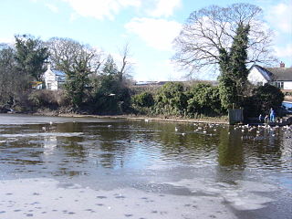
Raby Mere is a hamlet on the Wirral Peninsula, England. Adjacent to the Green Belt, woodland and open countryside, it is known for its mere, a lake that has been used for leisure purposes for many years. The hamlet of Raby is located two miles to the west.
Clatterbridge is a hamlet on the Wirral Peninsula, England, south-west of Bebington, close to the M53 motorway.
Rutland Park is an inner city residential neighbourhood in the southwest quadrant of Calgary, Alberta. It is bounded to the north by Richmond Road and 33 Avenue, to the east by Crowchild Trail, to the south by Glenmore Trail and to the west by 37 Street W.