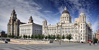
Merseyside is ceremonial and metropolitan county in North West England. It borders Lancashire to the north, Greater Manchester to the east, Cheshire to the south, the Welsh county of Flintshire across the Dee Estuary to the southwest, and the Irish Sea to the west. The largest settlement is the city of Liverpool.
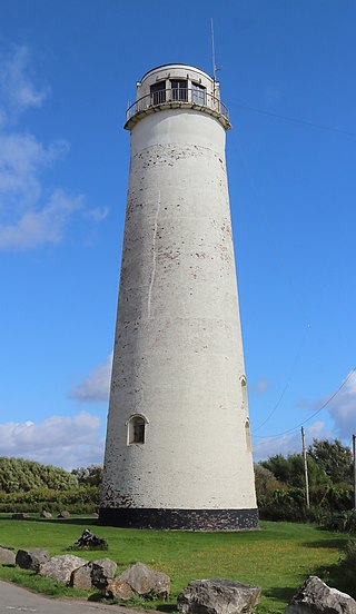
Leasowe Lighthouse is a historic lighthouse in Moreton on the Wirral Peninsula in Merseyside, England. The lighthouse was built in 1763 by The Mersey Docks and Harbour Company to guide shipping safely to the Port of Liverpool and is the oldest lighthouse built from bricks in the United Kingdom. The lighthouse became obsolete and was closed in 1908. The last lighthouse keeper was a Mrs. Williams, the only known female lighthouse keeper of the period.

Formby is a town and civil parish in the Metropolitan Borough of Sefton, Merseyside, England.

Hoylake is a seaside town in the Metropolitan Borough of Wirral, Merseyside, England. It is at the north west of the Wirral Peninsula, near West Kirby and where the River Dee meets the Irish Sea. Historically part of Cheshire, the Domesday Book of 1086 recorded it within the Hundred of Wilaveston.

Pensby is a large village on the Wirral Peninsula, in Merseyside, England. It is located 1.5 miles (2.4 km) to the north of the town of Heswall and approximately 0.5 miles (0.80 km) to the south west of Thingwall. Historically within Cheshire, the area is part of the Pensby and Thingwall Ward of the Metropolitan Borough of Wirral and is in the parliamentary constituency of Wirral West.

New Ferry is an urban area on the Metropolitan Borough of Wirral, Merseyside, England. It is located on the Wirral Peninsula, with the River Mersey to the east and the town of Bebington to the west. Within the boundaries of the historic county of Cheshire, the area was developed from the early nineteenth century.

Heswall is a town on the Wirral Peninsula, Merseyside, England and a ward of the Metropolitan Borough of Wirral. Before local government reorganisation on 1 April 1974 it was part of Cheshire.

Meols is a suburb in the Metropolitan Borough of Wirral in Merseyside, England. It forms a contiguous built up area with the nearby town of Hoylake which lies to the west. Historically in Cheshire, since 1 April 1974 it has been part of the Metropolitan Borough of Wirral, in Merseyside.
Moreton is a town in the Metropolitan Borough of Wirral in Merseyside, England. It is located approximately 3 mi (4.8 km) to the west of Wallasey. Historically part of Cheshire, it is now within the Metropolitan Borough of Wirral. The town was divided in 2004 between the local government wards of Leasowe & Moreton East and Moreton West & Saughall Massie. Moreton is also part of the parliamentary constituency of Wallasey.
Upton is a village in the northern part of the Wirral Peninsula, England, and is situated within 4 miles (6.4 km) of Birkenhead, 4 miles (6.4 km) of the Dee Estuary, a similar distance from the River Mersey, and 2 miles (3.2 km) from Liverpool Bay. The village is a ward of the Metropolitan Borough of Wirral in the metropolitan county of Merseyside. Upton was in the traditional county of Cheshire. At the 2011 census, the population was 16,130.

The Wirral Peninsula, known locally as The Wirral, is a peninsula in North West England. The roughly rectangular peninsula is about 15 miles (24 km) long and 7 miles (11 km) wide, and is bounded by the Dee Estuary to the west, the Mersey Estuary to the east, and Liverpool Bay to the north.
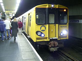
The Northern line is one of two commuter rail routes operated by Merseyrail and centred on Merseyside, England, the other being the Wirral line. The cross-city route runs from Hunts Cross in south Liverpool then branches in the north to terminate at Southport, Kirkby and Ormskirk (Lancashire).

Banks is a large coastal village in Lancashire, England, south of the Ribble estuary four miles (6 km) north-east of Southport. The village is administered by West Lancashire Borough and North Meols Parish Council. It is in the South Ribble parliamentary constituency. At the 2001 census the population of the North Meols civil parish was 3,792, rising to 4,146 by the 2011 census.
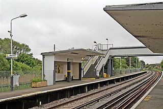
Manor Road railway station is a station in Merseyside, England that serves the towns of Hoylake and Meols. It is located on the West Kirby branch of the Wirral Line, part of the Merseyrail network.

Saughall Massie is a village on the Wirral Peninsula, Merseyside, England. It is part of the Moreton West & Saughall Massie Ward of the Metropolitan Borough of Wirral and the parliamentary constituency of Wallasey. A small village primarily made up of large fields owned by local farmers, it is bordered by Greasby, Meols, Moreton and Upton. At the 2001 census Saughall Massie had a population of 1,260.
Ashton Park is situated in Ashton-on-Ribble to the west of Preston, Lancashire, England. It has one bowling green, two play areas, with swings, roundabouts and climbing frames, several football pitches within a large, main field, and contains within it a magnificent country house. It is the headquarters of the Armed Forces Group, Dig in North West and Let's Grow Preston. These are all situated within the walled garden that also contains the Peace garden the fruit garden and Ashton Community Garden. It also has a beautiful woodland area, ornamental gardens and many flower beds. Ashton House, the large country house within the park, has recently undergone extensive repair and restoration and is particularly well used as a children's nursery school. Extensive parking facilities are provided in the park which is located immediately to the south of Blackpool Road, which proceeds westwards to Cottam. Nearby on the southern side are the docks, and Riversway complex, containing many offices and shops including Morrisons, McDonald's, and Pets at Home. To the west are the Larches and Savick estates and Lea.

"Red Frame/White Light" is the second single by English electronic band Orchestral Manoeuvres in the Dark (OMD). The song is about a red telephone box in Meols, on the Wirral peninsula in Merseyside, that was used by the group to make calls to organise their gigs in the late 1970s. The track is composed of two alternating major/minor sections, each built around a synthesizer hook. Lyrical content is minimal, comprising mostly brief, spoken word utterances. It was the band's first single to chart.
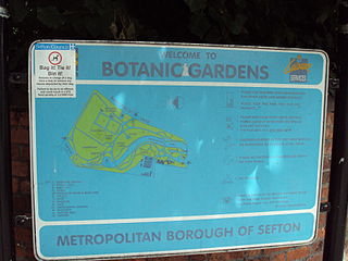
Southport Botanic Gardens is a botanical garden situated in the suburban village of Churchtown, Southport, in Merseyside, England. It is often called "The Jewel in the Crown" as it is nationally known for its floral displays, which have been featured in the BBC TV program Gardener's World.

St Hildeburgh's Parish Church is in Stanley Road, Hoylake, Wirral, Merseyside, England. It is an active Anglican church in the deanery of Wirral, North, the archdeaconry of Chester and the diocese of Chester. The church is recorded in the National Heritage List for England as a designated Grade II listed building.

