
The Algarve is the southernmost NUTS II region of continental Portugal. It has an area of 4,997 km2 (1,929 sq mi) with 467,495 permanent inhabitants and incorporates 16 municipalities.

Lagos is a city and municipality at the mouth of Bensafrim River and along the Atlantic Ocean, in the Barlavento region of the Algarve, in southern Portugal. The population of the municipality in 2011 was 31,049, in an area of 212.99 km2. The city of Lagos proper has a population of approximately 22,000. Typically, these numbers increase during the summer months, with the influx of visiting tourists and seasonal residents. While the majority of the population lives along the coast and works in tourism and services, the inland region is sparsely inhabited, with the majority of the people working in agriculture and forestry.

Portimão is a city and a municipality in the district of Faro, in the Algarve region of southern Portugal. The population in 2011 was 55,614, in an area of 182.06 km². It was formerly known as Vila Nova de Portimão. In 1924, it was incorporated as a cidade and became known merely as Portimão. Historically a fishing and shipbuilding centre, it has nonetheless developed into a strong tourist centre oriented along its beaches and southern coast. The two largest population centers in the Algarve are Portimão and Faro.

Faro District is the southernmost district of Portugal, coincident with the Algarve region. The administrative centre, or district capital, is the city of Faro.

Odemira is a town and a municipality in Beja District in the Portuguese region of Alentejo. The population in 2011 was 26,066, in an area of 1720.60 km2, making it the largest municipality of Portugal by area.

Monchique is a municipality of southern Portugal, in Faro District. The population in 2011 was 6,045, in an area of 395.30 km2.
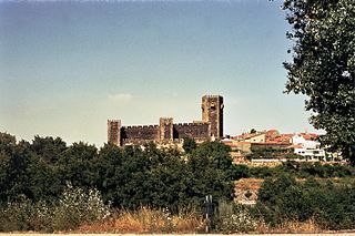
Sabugal is a city and a municipality in the District of Guarda, Portugal. A border municipality with Spain, the population of the municipality in 2011 was 12,544, in an area of 822.70 km2. The city proper, located along the Côa river, has a population of about 3,000 inhabitants. There is a castle in the city of Sabugal proper as well as other castles outside the urban centre in a number of places around the entire municipality of Sabugal. Those are the castles of Sortelha, Alfaiates, Vilar Maior and Vila do Touro. The municipal holiday is the Monday after Octave of Easter. It is also place for the Sabugal Dam built in 2000 and the river beach of Devesa, both located in the Côa river. At an elevation of roughly 750 m (2460 ft) above sea level, Sabugal is among the highest cities in Portugal.
Vila do Bispo is a municipality (concelho) in the Portuguese Algarve. The population in 2011 was 5,258, in an area of 179.06 km2.

São Marcos da Serra, also known simply as São Marcos, is a village and the seat of the homonymous civil parish in the municipality of Silves, in Algarve region, Portugal. The population of the entire civil parish in 2011 was 1,352, in an area of 166.07 km².

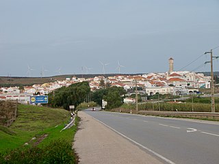
Aljezur is a parish (freguesia) in the municipality of Aljezur in Portugal. The population in 2011 was 3,365, in an area of 166.76 km².

Ferragudo is a Portuguese civil parish at the western border of the municipality of Lagoa. The population in 2011 was 1,973, in an area of 5.41 km². Ferragudo serves mainly as a bedroom community for its much larger neighbour, the city of Portimão; its residents routinely travel across the Arade River to work in the neighboring municipality.
Parchal is a town and a former civil parish in the municipality (concelho) of Lagoa, Portugal. In 2013, the parish merged into the new parish Estômbar e Parchal. The population in 2011 was 4,019, in an area of 3.86 km². It is situated in the northwest part of the Lagoa Municipality.
Alferce is a freguesia (parish) in the Monchique Municipality. The population in 2011 was 441, in an area of 96.12 km².
Monchique is a freguesia (parish) in Monchique Municipality. The population in 2011 was 4,817, in an area of 159.28 km².

Odeceixe is a village and civil parish in the northern part of the municipality of Aljezur, in the Portuguese Algarve, lying within the Nature Park of the Southwest Alentejo and Vincentine Coast. The village lies on the south bank of the Ribeira de Seixe, which here forms the border between the Algarve and Alentejo. The population of the parish in 2011 was 961, in an area of 41.91 km2.

Rogil is a Portuguese civil parish in Aljezur Municipality. It lies within the Southwest Alentejo and Vicentine Coast Natural Park. The population in 2011 was 1,126, in an area of 34.96 km².

Bordeira is a Portuguese civil parish in the municipality of Aljezur. The population in 2011 was 432, in an area of 79.87 km². It lies within the Southwest Alentejo and Vicentine Coast Natural Park, along the western coast of the Algarve in Faro District. The region, typical of the Algarve coastal areas, is dotted with many beaches, with the most important being the beaches of Praia do Amado and Praia da Bordeira, which attract both local and tourist vacationers. It contains the village of Carrapateira.
Alvor is a civil parish in the municipality of Portimão, in the southern Algarve of Portugal. The population in 2011 was 6,154, in an area of 15.25 km².

Aljezur is a town and municipality of the District of Faro and Algarve region, in Portugal. The population in 2011 was 5,884, in an area of 323.50 km². The municipality comprises 4 parishes.
Agrobom is a former civil parish, located in the municipality of Alfândega da Fé, in northern Portugal. In 2013, the parish merged into the new parish Agrobom, Saldonha e Vale Pereiro. It has less than 150 inhabitants in an area of 14.97 km² against the flank of the Serra de Bornes.


