
Gorham's Cave is a sea-level cave in the British overseas territory of Gibraltar. Though not a sea cave, it is often mistaken for one. Considered to be one of the last known habitations of the Neanderthals in Europe, the cave gives its name to the Gorham's Cave complex, which is a combination of four distinct caves of such importance that they are combined into a UNESCO World Heritage Site, the only one in Gibraltar. The three other caves are Vanguard Cave, Hyaena Cave, and Bennett's Cave.
Carlsbad Caverns National Park is a national park of the United States in the Guadalupe Mountains of southeastern New Mexico. The primary attraction of the park is the show cave Carlsbad Cavern. Visitors to the cave can hike in on their own via the natural entrance or take an elevator from the visitor center.

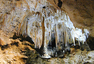
St. Michael's Cave or Old St. Michael's Cave is the name given to a network of limestone caves located within the Upper Rock Nature Reserve in the British Overseas Territory of Gibraltar, at a height of over 300 metres (980 ft) above sea level. According to Alonso Hernández del Portillo, the first historian of Gibraltar, its name is derived from a similar grotto in Monte Gargano near the Sanctuary of Monte Sant'Angelo in Apulia, Italy, where the archangel Michael is said to have appeared.

Lord Airey's Battery is an artillery battery in the British Overseas Territory of Gibraltar. It is located near the southern end of the Upper Rock Nature Reserve, just north of O'Hara's Battery. It was named after the Governor of Gibraltar, General Sir Richard Airey. Construction of the battery was completed in 1891. The first gun mounted on the battery was a 6-inch breech loading gun, which was replaced with a 9.2-inch Mark X BL gun by 1900. The gun at the battery was last fired in the 1970s. In 1997, it was discovered that Lord Airey's Shelter, adjacent to Lord Airey's Battery, was the site chosen for a covert World War II operation that entailed construction of a cave complex in the Rock of Gibraltar, to serve as an observation post. The battery is listed with the Gibraltar Heritage Trust.
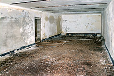
Operation Tracer was a secret Second World War Royal Navy military operation in Gibraltar, a British Overseas Territory and military base. The impetus for the stay-behind plan was the 1940 scheme by Germany to capture Gibraltar, code-named Operation Felix. Operation Tracer was the brainchild of Rear Admiral John Henry Godfrey, the Director of the Naval Intelligence Division of the Admiralty.
The Gibraltar Caving Group is an organisation based in the British Overseas Territory of Gibraltar. It forms the Caves and Cliffs Section of the Gibraltar Ornithological and Natural History Society. The group of skilled cavers and climbers has multiple roles, engaging in cave exploration and research, avian rescue, and rare plant discovery. It performs surveys and clears areas with limited access. However, it is perhaps most well known for the discovery that four of its members made in December 1996. While exploring tunnels in the southern portion of the Rock of Gibraltar, they found the entrance to Operation Tracer, also known colloquially as Stay Behind Cave. Rumours of a covert World War II observation post had circulated in Gibraltar for decades. The Gibraltar Caving Group continued its exploration and evaluation of the facility under the auspices of the Gibraltar Museum.
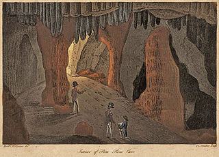
Poca Roca Cave is a cave in the British Overseas Territory of Gibraltar.

Cave S or Sewell's Cave is a limestone cave in the British Overseas Territory of Gibraltar. It is located on the eastern side of the Rock of Gibraltar, near Holy Boy's Cave. Prehistoric human remains were found in the cave in 1910, and the cave is listed by the Government of Gibraltar as a Palaeolithic site.
Fig Tree Cave is a cave in the British Overseas Territory of Gibraltar. It is located on the eastern cliffs of the Rock of Gibraltar, not far from Martin's Cave within the Upper Rock Nature Reserve. It is listed in the Heritage and Antiquities Act 2018 by the Government of Gibraltar.
The Genista Caves are a series of caves located under Windmill Hill in the British Overseas Territory of Gibraltar. Fossils of various mammals and human remains were discovered here in the mid-1860s. The name of the caves is a play on words based on Captain Frederick Brome's name, who discovered them.

The Goat's Hair Twin Caves are in the British Overseas Territory of Gibraltar. The caves are listed in the Heritage and Antiquities Act as they are sites of Palaeolithic and Neolithic archaeology.

Holy Boy's Cave is a cave in the British Overseas Territory of Gibraltar. It is one of the largest of the many caves in Gibraltar and it is on the eastern side of the Rock, near Cave S. It is believed to be archaeologically important and is listed in the Heritage and Antiquities Act 2018.

Leonora's Caves is a limestone cave system in the British Overseas Territory of Gibraltar. They are located within Old St. Michael's Cave.
Genista Battery is an artillery battery in the British Overseas Territory of Gibraltar.

The Gibraltar peninsula, located at the far southern end of Iberia, has great strategic importance as a result of its position by the Strait of Gibraltar where the Mediterranean Sea meets the Atlantic Ocean. It has repeatedly been contested between European and North African powers and has endured fourteen sieges since it was first settled in the 11th century. The peninsula's occupants – Moors, Spanish, and British – have built successive layers of fortifications and defences including walls, bastions, casemates, gun batteries, magazines, tunnels and galleries. At their peak in 1865, the fortifications housed around 681 guns mounted in 110 batteries and positions, guarding all land and sea approaches to Gibraltar. The fortifications continued to be in military use until as late as the 1970s and by the time tunnelling ceased in the late 1960s, over 34 miles (55 km) of galleries had been dug in an area of only 2.6 square miles (6.7 km2).

Mediterranean Steps is a path and nature trail in the British Overseas Territory of Gibraltar. One of the footpaths of Gibraltar, the path is located entirely within the Upper Rock Nature Reserve and was built by the British military but is now used by civilians as a pedestrian route linking Martin's Path to Lord Airey's Battery near the summit of Rock of Gibraltar. The path offers views over the Strait of Gibraltar, Windmill Hill, Europa Point, the Great Sand Dune, Gibraltar's east side beaches, the Mediterranean Sea and the Spanish Costa del Sol.

Windmill Hill or Windmill Hill Flats is one of a pair of plateaux, known collectively as the Southern Plateaux, at the southern end of the British Overseas Territory of Gibraltar. It is located just to the south of the Rock of Gibraltar, which descends steeply to the plateau. Windmill Hill slopes down gently to the south with a height varying from 120 metres (390 ft) at the north end to 90 metres (300 ft) at the south end. It covers an area of about 19 hectares, though about 6 hectares at the north end is built over. The plateau is ringed to the south and east with a line of cliffs which descend to the second of the Southern Plateaux, Europa Flats, which is itself ringed by sea cliffs. Both plateaux are the product of marine erosion during the Quaternary period and subsequent tectonic uplift. Windmill Hill was originally on the shoreline and its cliffs were cut by the action of waves, before the ground was uplifted and the shoreline moved further out to the edge of what is now Europa Flats.
The footpaths of Gibraltar provide access to key areas of the Upper Rock Nature Reserve, a refuge for hundreds of species of flora and fauna which in some cases are found nowhere else in Europe. The reserve occupies the upper part of the Rock of Gibraltar, a long and narrow mountain that rises to a maximum height of 424 metres (1,391 ft) above sea level, and constitutes around 40 per cent of Gibraltar's total land area. The unusual geology of the Rock of Gibraltar – a limestone peak adjoining a sandstone hinterland – provides a habitat for plants and animals, such as the Gibraltar candytuft and Barbary partridge, which are found nowhere else in mainland Europe. For many years, the Upper Rock was reserved exclusively for military use; it was fenced off for military purposes, but was decommissioned and converted into a nature reserve in 1993.

Orlova Chuka is a cave situated in the Danubian Plain, north-eastern Bulgaria. With a total length of 13,437 m, Orlova Chuka is the second longest cave in the country after Duhlata. The cave was discovered in 1941 and opened for tourists in 1957. Orlova Chuka is home to 14 species of bats.

Yagodinska Cave is a cave in the Rhodope Mountains, southern Bulgaria. It is included in the 100 Tourist Sites of Bulgaria and is named after the homonymous village nearby. With a total length of 10,500 m, Yagodinska is the fourth longest cave in the country after Kolkina Dupka, Duhlata and Orlova Chuka and the longest in the Rhodopes. Yagodinska Cave is home to 11 species of bats.


