
The Humboldt–Toiyabe National Forest (HTNF) is the principal U.S. National Forest in the U.S. state of Nevada, and has a smaller portion in Eastern California. With an area of 6,289,821 acres (25,454.00 km2), it is the largest National Forest of the United States outside Alaska.
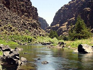
The Bruneau River is a 153-mile-long (246 km) tributary of the Snake River, in the U.S. states of Idaho and Nevada. It runs through a narrow canyon cut into ancient lava flows in southwestern Idaho. The Bruneau Canyon, which is up to 1,200 feet (370 m) deep and 40 miles (64 km) long, features rapids and hot springs, making it a popular whitewater trip.

Jarbidge is an unincorporated community in Elko County, Nevada, United States. Located at the bottom of the Jarbidge River's canyon near the north end of the Jarbidge Mountains, it lies within the Jarbidge Ranger District of the Humboldt-Toiyabe National Forest and is near the northwest edge of the Jarbidge Wilderness, approximately 10 miles (16 km) south of the Idaho–Nevada border. The ZIP code for Jarbidge is 89826.

The Humboldt River is an extensive river drainage system located in north-central Nevada. It extends in a general east-to-west direction from its headwaters in the Jarbidge, Independence, and Ruby Mountains in Elko County, to its terminus in the Humboldt Sink, approximately 225 miles away in northwest Churchill County. Most estimates put the Humboldt River at 290 miles (470 km) long however, due to the extensive meandering nature of the river, its length is more closely estimated at 380 miles (612 km). It is located within the Great Basin Watershed and is the third longest river in the watershed behind the Bear River at 355 miles (570 km) and the Sevier River at 325 miles (523 km). The Humboldt River Basin is the largest sub-basin of the Great Basin encompassing an area of 16,840 square miles (43,615 km2). It is the only major river system wholly contained within the state of Nevada.

The Jarbidge Wilderness is a wilderness area located in the Jarbidge Mountains of northern Elko County in northeastern Nevada, United States. It is contained within the Jarbidge Ranger District of the Humboldt-Toiyabe National Forest.

The Jarbidge Mountains are a mountain range in northern Elko County, Nevada, United States. The range includes multiple sub-ranges, including the Bruneau Range, Buck Creek Mountains, Copper Mountains, Elk Mountains, Fox Creek Range, Ichabod Range, Marys River Range, Salmon River Range and Wild Horse Range. The central core of the range, including most of the peaks above 10,500 feet (3,200 m), extends southward approximately 5 miles (8 km) from a point near the small community of Jarbidge.

The Fox Creek Range is a mountain range in Elko County, Nevada, United States. It is mostly contained within the Jarbidge Ranger District of the Humboldt-Toiyabe National Forest. The range is considered to be a sub-range of the Jarbidge Mountains.
The Ichabod Range is a mountain range in Elko County, Nevada. The northern portion of the range is contained within the Mountain City Ranger District of the Humboldt-Toiyabe National Forest. The range is considered to be a sub-range of the Jarbidge Mountains.
The Bruneau Range is a mountain range in Elko County, Nevada, United States. It is contained within the Mountain City Ranger District of the Humboldt-Toiyabe National Forest. The range is considered to be a sub-range of the Jarbidge Mountains.
The Buck Creek Mountains are a mountain range in Elko County, Nevada. They are contained within the Mountain City Ranger District of the Humboldt-Toiyabe National Forest. The range is considered to be a sub-range of the Jarbidge Mountains.
The Copper Mountains are a mountain range in Elko County, Nevada, United States.
The Wild Horse Range is a mountain range in Elko County, Nevada, United States, northwest of the Owyhee River's Wild Horse Reservoir. It is contained within the Mountain City Ranger District of the Humboldt-Toiyabe National Forest. The range is considered to be a sub-range of the Jarbidge Mountains.
The Elk Mountains are a mountain range in Elko County, Nevada, United States. The range is contained within the Jarbidge Ranger District of the Humboldt-Toiyabe National Forest and is considered to be a sub-range of the Jarbidge Mountains. The highest point is Elk Mountain.

The Jarbidge Ranger District is a 243,907-acre (98,706 ha) ranger district within the Humboldt-Toiyabe National Forest. It is located in northern Elko County, Nevada, United States, directly adjacent to the Mountain City Ranger District. The town of Jarbidge is contained within the district.

The Mountain City Ranger District is a 450,000-acre (180,000 ha) ranger district within the Humboldt-Toiyabe National Forest. It is located in northern Elko County, Nevada, United States, directly adjacent to the Jarbidge Ranger District. The town of Mountain City is contained within the district.

Matterhorn is the highest mountain in the Jarbidge Mountains of northern Elko County, Nevada, United States. It is the fifteenth-most topographically prominent peak in the state. The summit is located in the Jarbidge Wilderness, which is administered by the Jarbidge Ranger District of the Humboldt-Toiyabe National Forest. Its name is derived from the Matterhorn in the Alps of Europe, due mainly to the cliffs located immediately adjacent to the summit on the north and northeast.
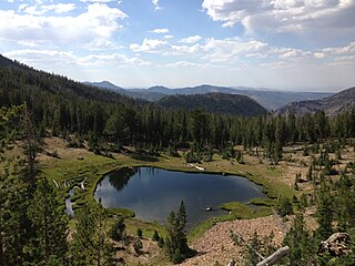
Jarbidge Lake is a glacial tarn in the Jarbidge Mountains of Elko County, Nevada, United States. It is within the Jarbidge Wilderness, which is administered by the Jarbidge Ranger District of the Humboldt-Toiyabe National Forest. The lake is near the southern terminus of the Jarbidge River Trail where it meets the West Marys River Trail and Emerald Lake Trail, and is just below Emerald Lake Pass. Jarbidge Lake is the principal source of the Jarbidge River.

Marys River Peak is the highest mountain in the Marys River Range of northern Elko County, Nevada, United States. It is located within the Jarbidge Wilderness, which is administered by the Jarbidge Ranger District of the Humboldt-Toiyabe National Forest. The peak's name is derived from the Marys River, a tributary of the Humboldt.

Jarbidge Peak is the second highest mountain in the Jarbidge Mountains of northern Elko County, Nevada, United States. It is located within the Jarbidge Ranger District of the Humboldt-Toiyabe National Forest. The boundary of the Jarbidge Wilderness crosses the peak.
Copper Basin is a basin located between the Copper Mountains and Fox Creek Range of northern Elko County, Nevada, United States. The basin, located on the border of the Mountain City and Jarbidge ranger districts within the Humboldt-Toiyabe National Forest, is known for its displays of wildflowers during early summer. It is accessed via Elko County Route 748, also known as Charleston-Jarbidge Road, by way of either Charleston or Jarbidge.
