Massillon, Iowa

Last updated

Massillon, Iowa
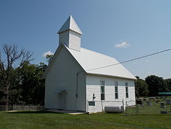
Church Upon a Hill - Massillon, Iowa.JPG
Church Upon a Hill
USA Iowa location map.svg
Red pog.svg
Massillon, Iowa
Location within the state of Iowa
Usa edcp location map.svg
Red pog.svg
Massillon, Iowa
Massillon, Iowa (the United States)
Coordinates: 41°54′53″N90°55′22″W / 41.91472°N 90.92278°W / 41.91472; -90.92278
Country Flag of the United States (23px).png  United States
State Flag of Iowa.svg  Iowa
County Cedar County
Time zone UTC-6 (Central (CST))
  Summer (DST) UTC-5 (CDT)
Area code 563

Massillon is an unincorporated community in Massillon Township, Cedar County, Iowa, United States. It is south of the Wapsipinicon River on County Road Y24, west of Toronto and north of Lowden in the northeastern corner of the county, at 41.914844N, -90.922851W. [1]

History

The area where the town of Massillon was founded was originally known as Denson's Ferry, named after a Joseph Denson who ran a ferry on the Wapsipinicon River. [2] The town plat was founded in 1854 and was a station along the Davenport & Northern Railroad. [3] The town was named after the city of Massillon, Ohio, located 540 miles (870 km) to the east on US 30. [4]

The first bridge was built over the Wapsipinicon River at Massillon in 1868 at the expense of $4,000. [5]

Related Research Articles

<span class="mw-page-title-main">Jones County, Iowa</span> County in Iowa, United States

Jones County is a county in the U.S. state of Iowa. As of the 2020 census the population was 20,646. The county seat is Anamosa. The county was founded in 1837 and named after George Wallace Jones, a United States senator and member of Congress.

<span class="mw-page-title-main">Cedar County, Iowa</span> County in Iowa, United States

Cedar County is a county located in the U.S. state of Iowa. As of the 2020 census, the population was 18,505. Its county seat is Tipton. The county is named for the Cedar River, which runs through the county.

<span class="mw-page-title-main">Independence, Iowa</span> City in Iowa, United States

Independence is a city in, and the county seat of, Buchanan County, Iowa, United States. The population was 6,064 at the 2020 census.

<span class="mw-page-title-main">Anamosa, Iowa</span> City in Iowa, United States

Anamosa is a city in Jones County, Iowa, United States. The population was 5,450 at the 2020 census. It is the county seat of Jones County.

<span class="mw-page-title-main">Ely, Iowa</span> City in Iowa, United States

Ely is a city in Linn County, Iowa. The population was 2,328 at the time of the 2020 census. It is part of the Cedar Rapids metropolitan area

<span class="mw-page-title-main">Wapsipinicon River</span> River in Iowa and Minnesota in the United States of America

The Wapsipinicon River is a tributary of the Mississippi River, approximately 300 miles (480 km) long, starting near the southeastern border of Minnesota and running through northeastern Iowa in the United States. It drains a rural farming region of rolling hills and bluffs north of Waterloo and Cedar Rapids.

LaMoille is a rural unincorporated community in Marshall County, Iowa, United States, lying halfway between Marshalltown and State Center.

<span class="mw-page-title-main">Cedar Township, Benton County, Iowa</span> Township in Iowa, United States

Cedar Township is one of twenty townships in Benton County, Iowa, USA. As of the 2000 census, its population was 533.

<span class="mw-page-title-main">Taylor Township, Benton County, Iowa</span> Township in Iowa, United States

Taylor Township is one of twenty townships in Benton County, Iowa, United States. As of the 2000 census, its population was 781.

<span class="mw-page-title-main">Cass Township, Cedar County, Iowa</span> Township in Iowa, United States

Cass Township is one of seventeen townships in Cedar County, Iowa, United States. As of the 2000 census, its population was 295.

<span class="mw-page-title-main">Iowa Township, Cedar County, Iowa</span> Township in Iowa, United States

Iowa Township is one of seventeen townships in Cedar County, Iowa, United States. As of the 2000 census, its population was 460.

<span class="mw-page-title-main">Linn Township, Cedar County, Iowa</span> Township in Iowa, United States

Linn Township is one of the seventeen townships in Cedar County, Iowa, United States. As of the 2000 census, its population was 201.

<span class="mw-page-title-main">Springdale Township, Cedar County, Iowa</span> Township in Iowa, United States

Springdale Township is one of seventeen townships in Cedar County, Iowa, United States. As of the 2000 census, its population was 2,857.

<span class="mw-page-title-main">Springfield Township, Cedar County, Iowa</span> Township in Iowa, United States

Springfield Township is one of seventeen townships in Cedar County, Iowa, United States. As of the 2000 census, its population was 1,138.

<span class="mw-page-title-main">California Junction, Iowa</span> Census-designated place in Iowa, United States

California Junction is an unincorporated community and census-designated place (CDP) in Harrison County, Iowa, United States. It lies just east of the junction between the east–west and north–south lines of the former Sioux City and Pacific Railroad. In the 2010 census it had a population of 85 inhabitants and a population density of 184.38 people per square mile.

Paris is an unincorporated community in Linn County, Iowa, United States. It is located at the intersections of Sutton Road and County Highway D66 near the banks of the Wapsipinicon River. It is northwest of Central City and southwest of Coggon, at 42.238459N, −91.578187W.

<span class="mw-page-title-main">Downey, Iowa</span> Unincorporated community in Iowa, United States

Downey is an unincorporated community in Cedar County, Iowa, United States.

<span class="mw-page-title-main">Rochester, Iowa</span> Census-designated place in Iowa, United States

Rochester is an unincorporated community and census-designated place (CDP) in Rochester Township, Cedar County, Iowa, United States. As of the 2010 census it had a population of 133.

Cedar Bluff is an unincorporated community in Cedar County, Iowa, United States.

Buena Vista is an unincorporated community in Clinton County, Iowa, United States, located on the north bank of the Wapsipinicon River, almost 7 miles south of Calamus and two miles east of Dixon. From 1849 to 1914, it had a post office, sited in the southwestern part of Section 9 of Olive Township, at the southeast corner of the intersection of 178th Avenue and 298th Street.

References

  1. "US Gazetteer files: 2010, 2000, and 1990". United States Census Bureau. February 12, 2011. Retrieved April 23, 2011.
  2. The History of Cedar County, Iowa: Containing a History of the County, Its Cities, Towns, etc. Western Historical Company. 1878. p. 546.
  3. The history of Cedar County, Iowa, Western Historical Co., 1878.
  4. Savage, Tom (2007). A Dictionary of Iowa Place-Names, p. 145. University Of Iowa Press. ISBN   1-58729-531-8.
  5. Aurner, Clarence Ray (1910). A Topical History of Cedar County, Iowa, Volume 1. S. J. Clarke. pp.  76.