Downey, Iowa | |
|---|---|
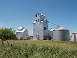 Grain bins along the Iowa Interstate railroad tracks in Downey | |
 Downey, Iowa | |
| Coordinates: 41°36′58″N91°20′55″W / 41.61611°N 91.34861°W | |
| Country | United States |
| State | Iowa |
| County | Cedar |
| Township | Springdale |
| Area | |
• Total | 0.68 sq mi (1.75 km2) |
| • Land | 0.68 sq mi (1.75 km2) |
| • Water | 0.00 sq mi (0.00 km2) |
| Elevation | 719 ft (219 m) |
| Population (2020) | |
• Total | 112 |
| • Density | 165.93/sq mi (64.04/km2) |
| Time zone | UTC-6 (Central (CST)) |
| • Summer (DST) | UTC-5 (CDT) |
| ZIP code | 52358 [3] |
| Area code | 319 |
| GNIS feature ID | 2806474 [2] |
Downey is an unincorporated community and census-designated place (CDP) in Cedar County, Iowa, United States. [2]
