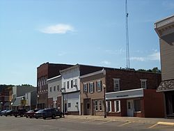
The first settler to build a home in the area that was to be known as Wilton in the new state of Iowa (1846) was Mr. Christian Marolf who came in July 1849,[5] and erected of a small log house opposite the GermanLutheran church. When he built his home Mr. Marolf could only see the home of Mr. Stearns just west of town on the south side of the Moscow road. Mr. Marolf was soon followed by Mr. Ben Maurer in 1850 whose land now comprises North Wilton and Peter Marolf in 1851, which is now known as Marolf's addition.[6] North Wilton is at present (1947) not within the corporate limits of Wilton. The city was once home to the Wilton German English College from 1894 to 1905. The campus of the college was later turned into City Park, and some of the college's buildings remain to this day.
Geography
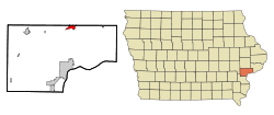
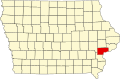
According to the United States Census Bureau, the city has a total area of 1.95 square miles (5.05km2), all land.[7] The city sits at an elevation of 679 feet.
As of the census of 2020,[9] there were 2,924 people, 1,166 households, and 761 families residing in the city. The population density was 1,423.2 inhabitants per square mile (549.5/km2). There were 1,255 housing units at an average density of 610.8 per square mile (235.8/km2). The racial makeup of the city was 92.6% White, 0.5% Black or African American, 0.2% Native American, 0.3% Asian, 0.0% Pacific Islander, 1.0% from other races and 5.3% from two or more races. Hispanic or Latino persons of any race comprised 4.4% of the population.
Of the 1,166 households, 31.1% of which had children under the age of 18 living with them, 50.3% were married couples living together, 6.9% were cohabitating couples, 25.6% had a female householder with no spouse or partner present and 17.2% had a male householder with no spouse or partner present. 34.7% of all households were non-families. 28.6% of all households were made up of individuals, 13.4% had someone living alone who was 65 years old or older.
The median age in the city was 38.6 years. 27.4% of the residents were under the age of 20; 4.3% were between the ages of 20 and 24; 25.3% were from 25 and 44; 25.8% were from 45 and 64; and 17.3% were 65 years of age or older. The gender makeup of the city was 48.4% male and 51.6% female.
2010 census
As of the census[10] of 2010, there were 2,802 people, 1,155 households, and 767 families residing in the city. The population density was 1,436.9 inhabitants per square mile (554.8/km2). There were 1,231 housing units at an average density of 631.3 per square mile (243.7/km2). The racial makeup of the city was 97.5% White, 0.3% African American, 0.1% Asian, 0.9% from other races, and 1.2% from two or more races. Hispanic or Latino of any race were 2.6% of the population.
There were 1,155 households, of which 34.2% had children under the age of 18 living with them, 50.5% were married couples living together, 10.3% had a female householder with no husband present, 5.6% had a male householder with no wife present, and 33.6% were non-families. 28.1% of all households were made up of individuals, and 10.7% had someone living alone who was 65 years of age or older. The average household size was 2.43 and the average family size was 2.97.
The median age in the city was 37.7 years. 26.2% of residents were under the age of 18; 8.1% were between the ages of 18 and 24; 25.5% were from 25 to 44; 27.4% were from 45 to 64; and 13% were 65 years of age or older. The gender makeup of the city was 49.7% male and 50.3% female.
2000 census
As of the census[11] of 2000, there were 2,842 people, 1,105 households, and 784 families residing in the city. The population density was 1,509.5 inhabitants per square mile (582.8/km2). There were 1,141 housing units at an average density of 608.8 per square mile (235.1/km2). The racial makeup of the city was 97.74% White, 0.21% African American, 0.21% Native American, 0.46% Asian, 0.60% from other races, and 0.78% from two or more races. Hispanic or Latino of any race were 2.01% of the population.
There were 1,105 households, out of which 36.1% had children under the age of 18 living with them, 58.2% were married couples living together, 8.3% had a female householder with no husband present, and 29.0% were non-families. 25.3% of all households were made up of individuals, and 8.7% had someone living alone who was 65 years of age or older. The average household size was 2.54 and the average family size was 3.05.
In the city, the population was spread out, with 27.7% under the age of 18, 8.5% from 18 to 24, 30.5% from 25 to 44, 20.0% from 45 to 64, and 13.2% who were 65 years of age or older. The median age was 35 years. For every 100 females, there were 93.8 males. For every 100 females age 18 and over, there were 93.7 males.
The median income for a household in the city was $44,278, and the median income for a family was $49,615. Males had a median income of $37,146 versus $23,350 for females. The per capita income for the city was $18,445. About 5.5% of families and 6.5% of the population were below the poverty line, including 9.2% of those under age 18 and 3.8% of those age 65 or over.
Arts and culture
Wilton City Hall
Witon has a library/community center building in the northeast section of the city, near the high school that provides numerous resources to residents.
Wilton has four parks. The City Park (known by residents as the Blue Park) in the heart of the town had an indoor swimming pool (torn down in 2024) as well as a playground, shelter house, and baseball field. Westview Park is on the west side of town and has tennis courts, playground equipment, a walking path, and a ball field. Elder Park is in the downtown area and has a small picnic area. Cherrydale Park on the southside contains three baseball fields and a playground.
Religion
First Presbyterian Church
Wilton is home to many churches, including St. Mary's Catholic Church, Presbyterian Church, Grace United Church of Christ, Heartland Fellowship Church, United Methodist Church, and the Zion Lutheran Church.
Education
Public schools
The Wilton Community School District, home to the Wilton Beavers and part of the River Valley Conference, serves Wilton, Moscow, and the surrounding rural areas. The school district includes an elementary school and a junior/senior high school, which is now a connecting part of the new elementary. The school has a student-teacher ratio of 12:1.[14][15]
Media
Wilton-Durant Advocate News is a weekly newspaper in the area. Daily newspapers such as The Muscatine Journal and Quad-City Times are available.
Wilton Jr./Sr. High School has a student-run school news website called This Just In,[16] which is maintained during the school year by journalism students. The class also produces a student newspaper called "The Beaver Tale" which is printed monthly during the school year in the Advocate News.
Wilton is three miles (5km) south of Interstate 80, at the junction of County Highway F58 and Iowa Highway 38, within driving distance of Muscatine, the Quad Cities, Iowa City, and Cedar Rapids. The Iowa Interstate Railroad passes through the city and provides service to local industries. The Quad City International Airport is 30 miles east of Wilton providing non-stop flights to destinations throughout the country. Wilton sits along the historic transcontinental U.S. Route 6, though this section was transferred to Iowa Highway 927 and later to county F58.
Utilities
Water tower in Wilton
Electricity is provided by Wilton Municipal Light and Power Company and water by the city water department, which operates its own water treatment plant. The city has a 500,000 gallon water tower on the west side of town near the industrial park, and another 300,000-gallon tower in the center of the city.
Healthcare
Trinity Medical Center in Muscatine has a "physicians' clinic" located in Wilton. The closest hospitals are located in Muscatine (Trinity-Muscatine), the Quad Cities (Genesis West, Genesis East, Trinity-Bettendorf), and Iowa City (University of Iowa Hospitals and Clinics, Mercy Hospital, and the Veteran's Hospital).
Police Department and Fire Department
The city is served by the Wilton Police Department[17] and Wilton Fire Department.[18]
This page is based on this Wikipedia article Text is available under the CC BY-SA 4.0 license; additional terms may apply. Images, videos and audio are available under their respective licenses.