Related Research Articles

Seismology is the scientific study of earthquakes and the propagation of elastic waves through the Earth or through other planet-like bodies. The field also includes studies of earthquake environmental effects such as tsunamis as well as diverse seismic sources such as volcanic, tectonic, glacial, fluvial, oceanic, atmospheric, and artificial processes such as explosions. A related field that uses geology to infer information regarding past earthquakes is paleoseismology. A recording of Earth motion as a function of time is called a seismogram. A seismologist is a scientist who does research in seismology.

Geophysics is a subject of natural science concerned with the physical processes and physical properties of the Earth and its surrounding space environment, and the use of quantitative methods for their analysis. The term geophysics sometimes refers only to solid earth applications: Earth's shape; its gravitational and magnetic fields; its internal structure and composition; its dynamics and their surface expression in plate tectonics, the generation of magmas, volcanism and rock formation. However, modern geophysics organizations and pure scientists use a broader definition that includes the water cycle including snow and ice; fluid dynamics of the oceans and the atmosphere; electricity and magnetism in the ionosphere and magnetosphere and solar-terrestrial physics; and analogous problems associated with the Moon and other planets.
An inverse problem in science is the process of calculating from a set of observations the causal factors that produced them: for example, calculating an image in X-ray computed tomography, source reconstruction in acoustics, or calculating the density of the Earth from measurements of its gravity field. It is called an inverse problem because it starts with the effects and then calculates the causes. It is the inverse of a forward problem, which starts with the causes and then calculates the effects.
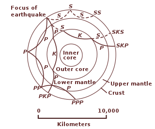
Seismic tomography is a technique for imaging the subsurface of the Earth with seismic waves produced by earthquakes or explosions. P-, S-, and surface waves can be used for tomographic models of different resolutions based on seismic wavelength, wave source distance, and the seismograph array coverage. The data received at seismometers are used to solve an inverse problem, wherein the locations of reflection and refraction of the wave paths are determined. This solution can be used to create 3D images of velocity anomalies which may be interpreted as structural, thermal, or compositional variations. Geoscientists use these images to better understand core, mantle, and plate tectonic processes.
The moment magnitude scale is a measure of an earthquake's magnitude based on its seismic moment. It was defined in a 1979 paper by Thomas C. Hanks and Hiroo Kanamori. Similar to the local magnitude scale (ML ) defined by Charles Francis Richter in 1935, it uses a logarithmic scale; small earthquakes have approximately the same magnitudes on both scales.
Keith Edward Bullen FAA FRS was a New Zealand-born mathematician and geophysicist. He is noted for his seismological interpretation of the deep structure of the Earth's mantle and core. He was Professor of Applied Mathematics at the University of Sydney in Australia from 1945 until 1971.

In seismology, the Gutenberg–Richter law expresses the relationship between the magnitude and total number of earthquakes in any given region and time period of at least that magnitude.

Geodynamics is a subfield of geophysics dealing with dynamics of the Earth. It applies physics, chemistry and mathematics to the understanding of how mantle convection leads to plate tectonics and geologic phenomena such as seafloor spreading, mountain building, volcanoes, earthquakes, faulting and so on. It also attempts to probe the internal activity by measuring magnetic fields, gravity, and seismic waves, as well as the mineralogy of rocks and their isotopic composition. Methods of geodynamics are also applied to exploration of other planets.

Albert Tarantola was a Spanish-born physicist, of the University of Paris and the Institut de Physique du Globe (IPGP), and author of the book Probabilistic Formulation of Inverse Problems. Tarantola was the leader of the Geophysical Tomography Group, that during the years 1985—2000 developed methods for the interpretation of seismic waveform data. Beyond just this field, he is widely credited with popularizing the idea that inverse problems can be interpreted in a statistical sense, yielding the Bayesian perspective of inverse problems. Apart from his scientific research, Tarantola taught both at IPGP and at other universities.
Episodic tremor and slip (ETS) is a seismological phenomenon observed in some subduction zones that is characterized by non-earthquake seismic rumbling, or tremor, and slow slip along the plate interface. Slow slip events are distinguished from earthquakes by their propagation speed and focus. In slow slip events, there is an apparent reversal of crustal motion, although the fault motion remains consistent with the direction of subduction. ETS events themselves are imperceptible to human beings and do not cause damage.
Computational geophysics is the field of study that uses any type of numerical computations to generate and analyze models of complex geophysical systems. It can be considered an extension, or sub-field, of both computational physics and geophysics. In recent years, computational power, data availability, and modelling capabilities have all improved exponentially, making computational geophysics a more populated discipline. Due to the large computational size of many geophysical problems, high-performance computing can be required to handle analysis. Modeling applications of computational geophysics include atmospheric modelling, oceanic modelling, general circulation models, and geological modelling. In addition to modelling, some problems in remote sensing fall within the scope of computational geophysics such as tomography, inverse problems, and 3D reconstruction.
Thomas H. (Tom) Heaton is an American seismologist, known for his influential contributions in earthquake source physics and earthquake early warning. Currently he is the professor of geophysics and civil engineering at Caltech and one of the world’s leading experts on seismology.
In seismology, a tsunami earthquake is an earthquake which triggers a tsunami of significantly greater magnitude, as measured by shorter-period seismic waves. The term was introduced by Japanese seismologist Hiroo Kanamori in 1972. Such events are a result of relatively slow rupture velocities. They are particularly dangerous as a large tsunami may arrive at a coastline with little or no warning.

The École et Observatoire des Sciences de la Terre is an institution under the supervisory authority of the University of Strasbourg and the CNRS in charge of education, research, observation in Earth Science and its diffusion. Situated in two buildings located on the central campus of the University of Strasbourg, EOST consist of more than 150 permanent employees among its staff.

Near-surface geophysics is the use of geophysical methods to investigate small-scale features in the shallow subsurface. It is closely related to applied geophysics or exploration geophysics. Methods used include seismic refraction and reflection, gravity, magnetic, electric, and electromagnetic methods. Many of these methods were developed for oil and mineral exploration but are now used for a great variety of applications, including archaeology, environmental science, forensic science, military intelligence, geotechnical investigation, treasure hunting, and hydrogeology. In addition to the practical applications, near-surface geophysics includes the study of biogeochemical cycles.
The following outline is provided as an overview of and topical guide to geophysics:

Inverse modeling is a mathematical technique where the objective is to determine the physical properties of the subsurface of an earth region that has produced a given seismogram. Cooke and Schneider (1983) defined it as calculation of the earth's structure and physical parameters from some set of observed seismic data. The underlying assumption in this method is that the collected seismic data are from an earth structure that matches the cross-section computed from the inversion algorithm. Some common earth properties that are inverted for include acoustic velocity, formation and fluid densities, acoustic impedance, Poisson's ratio, formation compressibility, shear rigidity, porosity, and fluid saturation.

Republican Seismic Survey Center (RSSC) is the main organization, involved in the research and study of earthquakes on the territory of Azerbaijan Republic. Seismological, geophysical, geochemical and geodynamic complex researches are conducted in the center.
Alik Ismail-Zadeh is a German/Russian mathematical geophysicist known for his contribution to computational geodynamics. and natural hazard studies, pioneering work on data assimilation in geodynamics as well as for outstanding service to the Earth and space science community. He is a Senior Scientist of the Karlsruhe Institute of Technology in Germany, and Chief Scientist, Research Professor and Scientific Leader of Research Group “Computational Geodynamics and Geohazard Modeling” of the Russian Academy of Sciences Institute of Earthquake Prediction Theory and Mathematical Geophysics, Moscow, Russia.
References
- Parker, Robert L. (1994). Geophysical Inverse Theory . Princeton University Press. ISBN 0-691-03634-9.
- Pedlosky, Joseph (2005). Geophysical Fluid Dynamics. Society for Industrial and Applied Mathematics. ISBN 0-89871-572-5.
- Tarantola, Albert (1987). Inverse Problem Theory and Methods for Model Parameter Estimation . Springer-Verlag. ISBN 0-387-96387-1.
- Turcotte, Donald L. (1997). Fractals and Chaos in Geology and Geophysics. Cambridge University Press. ISBN 0-521-56164-7.
- Wang, Bin; Zou, Xiaolei; Zhu, Jiang (2000). "Data assimilation and its applications". Proceedings of the National Academy of Sciences of the United States of America . 97 (21): 11143–11144. Bibcode:2000PNAS...9711143W. doi: 10.1073/pnas.97.21.11143 . PMC 34050 . PMID 11027322.
| Overview | |
|---|---|
| Subfields | |
| Physical phenomena | |