
A qanat or kariz, is a system for transporting water from an aquifer or water well to the surface, through an underground aqueduct. Constructed in Iran, Iraq and numerous other societies, this is an ancient system of water supply which allows water to be transported over long distances in hot dry climates without loss of much of the water to evaporation. The system has the advantage of being resistant to natural disasters such as earthquakes and floods, and to deliberate destruction in war. Furthermore, it is almost insensitive to the levels of precipitation, delivering a flow with only gradual variations from wet to dry years.

Iquique Province is one of two provinces in the northern Chilean region of Tarapacá. Its capital is the port city of Iquique.

Putre is a Chilean town and commune, capital of the Parinacota Province in the Arica-Parinacota Region. It is located 130 km (81 mi) east of Arica, at an altitude of 3,500 m (11,483 ft). The town is backdropped by Taapaca volcanic complex.
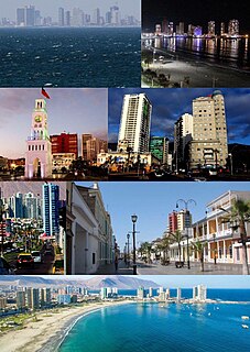
Iquique is a port city and commune in northern Chile, capital of both the Iquique Province and Tarapacá Region. It lies on the Pacific coast, west of the Pampa del Tamarugal, which is part of the Atacama Desert. It has a population of 191,468 according to the 2017 census. It is also the main commune of Greater Iquique. The city developed during the heyday of the saltpetre mining in the Atacama Desert in the 19th century. Once a Peruvian city with a large Chilean population, it was conquered by Chile in the War of the Pacific (1879–1883). Today it is one of only two free ports of Chile, the other one being Punta Arenas, in the country's far south.

Huara is a Chilean town and commune in Tamarugal Province, Tarapacá Region. It is located 45 km (28 mi) or northeast of Iquique. The village is crossed by the Pan-American Highway and is the crossing point for the road that goes to Oruro in Bolivia. This road also serves as access to the Atacama Giant site and the Volcán Isluga National Park.
La Tirana is a Chilean town in the commune of Pozo Almonte in El Tamarugal Province, Tarapacá Region. The town lies in an oasis in the middle of the Pampa del Tamarugal, about 72 km inland from the port of Iquique.

Pica is a Chilean town and commune in Tamarugal Province, Tarapacá Region. Situated in the inland of the Atacama Desert on an oasis, Pica is famous for its small and unusually acidic limes known as Limón de Pica. The town has a communal hot spring with a surface temperature of 40 °C, which makes it a popular bath place in the middle of the desert. It has hotels and all basic services. The town lies four kilometers to the northeast of the oasis village of Matilla.
Sierra Gorda is a Chilean commune in Antofagasta Province, Antofagasta Region. The total population was 1,516 as of the 2012 census. The two main settlements are the villages of Sierra Gorda and Baquedano.

The Atacama Desert is a desert plateau in South America covering a 1,600 km (990 mi) strip of land on the Pacific coast, west of the Andes Mountains. The Atacama Desert is the driest nonpolar desert in the world, as well as the only true desert to receive less precipitation than the polar deserts and the largest fog desert in the world. Both regions have been used as experimentation sites on Earth for Mars expedition simulations. According to estimates, the Atacama Desert occupies 105,000 km2 (41,000 sq mi), or 128,000 km2 (49,000 sq mi) if the barren lower slopes of the Andes are included. Most of the desert is composed of stony terrain, salt lakes (salares), sand, and felsic lava that flows towards the Andes.

Puquios are ancient systems of subterranean aqueducts which allow water to be transported over long distances in hot dry climates without loss of much of the water to evaporation. Puquios are found in the coastal deserts of southern Peru, especially in the Nazca region, and northern Chile. Forty-three puquios in the Nazca region were still in use in the early 21st century and relied upon to bring fresh water for irrigation and domestic use into desert settlements. The origin and dating of the Nazca puquios is disputed, although some archaeologists have estimated that their construction began about 500 CE by indigenous people of the Nazca culture.

Sibaya is a hamlet in the Altiplano of northern Chile. As of 2017 Sibaya had 46 inhabitants and 123 homes. It has an irrigation system based on underground aqueducts tapping an aquifer.
Pica Aquifer located in Tarapacá Region of northern Chile is one of the most important aquifers of Atacama Desert. The water of the aquifer is tapped by a system of underground aqueducts known as puquios to irrigate the oases of Pica and Matilla. The uppermost part of the aquifer is within loosely consolidated alluvial and aeolian sediments deposited in the Quaternary period. The recharge zone of Pica Aquifer is estimated to lie between ~3,000 and 4,000 meters above sea level.
Puquio de Núñez is a small oasis and orchard in the Atacama Desert of Chile. The oasis is irrigated by an underground canal, a puquio tapping Pampa del Tamarugal Aquifer. Puqui de Núñez lies about 10 kilometers south of the nearby oases of Matilla and Pica. As the puquios of Pica and Matilla tap the Pica Aquifer, it is thought that the hydraulic divide between the aquifers of Pampa del Tamarugal and Pica should be between Puquio de Núñez and Matilla.
Pampa del Tamarugal Aquifer located in Tarapacá Region of northern Chile is one of the most important aquifers of Atacama Desert.
La Calera is a small oasis and orchard in the Atacama Desert of Chile. The oasis is irrigated by an underground canal, a puquio tapping an aquifer. Located at 1,390 meters above sea level La Calera lies about 15 kilometers north of the larger oasis of Pica.
Limón de Pica is an unusually acidic lime from the oasis town of Pica in Atacama Desert. Limóns de Pica have had an appellation of origin since 2010. The environment where the limes are grown has a mild microclimate that does not display the typical high temperature oscillations seen in many of the world's deserts. Six producers, compromising 20% of the agricultural output of the oasis, are organised in Oasis Pica Coop. As of 2019, the coop was working to certify its products as organic and enforce the appellation control of limón de Pica.
The paradas method was a process to extract nitrate from caliche by leaching. In this method caliche was boiled in water in large pans called "paradas". It was a firewood and labour-intensive process. The paradas method was phased out in the 1850s by a new system invented by Pedro Gamboni which required less fuel and labour.
Huantajaya or San Agustín de Huantajaya was a silver mine in Chile in the Tarapacá area of Atacama Desert east of Iquique. The silver riches of Tarapacá were known to the Spanish since the time of the conquest of the Inca Empire. Pedro Pizarro mentions Tarapacá as region with silver in his 1571 book Relación del descubrimiento y conquista de los reinos del Perú. The main period of activity was in the 18th century. During this time the nearby oasis town of Pica prospered as a supply center.
Collacagua is a Chilean town. It is a small Aymara hamlet in the highlands of the Tarapacá Region (Chile). Collacagua is located 86 km from Pica, between the towns of Cancosa and Lirima. The houses of which the oldest are made of stone, adobe and mud. The latter are similar to the ancestral Aymara architectural style but their materials are not the same.
Lirima is a Chilean town. It is a town that is located approximately 138km east of Huara, in the Tarapacá Region, Chile. It is located in the Commune of Pica. It is a town founded by a group of Aymara families. It is famous for its spun wool fabrics dyed with the traditional processes of the inhabitants themselves. It is located in Pampa Columtucsa, at the foot of Cerro Lirima and several kilometers from Laguna Quantija and Apacheta de Irpa or Cancosa Border Crossing.


