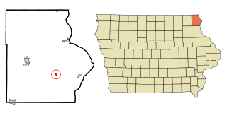
Maud, Iowa

Last updated
Maud, Iowa
USA Iowa location map.svg
Red pog.svg
Maud, Iowa
Usa edcp location map.svg
Red pog.svg
Maud, Iowa
Coordinates: Coordinates: 43°13′35″N91°22′13″W / 43.22639°N 91.37028°W / 43.22639; -91.37028
Country United States
State Iowa
County Allamakee
Elevation
942 ft (287 m)
Time zone UTC-6 (Central (CST))
  Summer (DST) UTC-5 (CDT)
Area code(s) 563
GNIS feature ID464646

Maud is an unincorporated community in Allamakee County, Iowa, United States. [1]

History

Maud in Allamakee County, Iowa, in 1903 Allamakee County Iowa 1903.png
Maud in Allamakee County, Iowa, in 1903

Maud got its start as a way station on the railroad. [2] Maud's population was 12 in 1902, [3] and was also 12 in 1925. [4]

Related Research Articles

Amish, Iowa Unincorporated community in Iowa, United States

Amish is an unincorporated community in Johnson County, Iowa, United States. It is part of the Iowa City Metropolitan Statistical Area. Its altitude is 758 feet (231 m), and it lies at 41°32′9″N91°47′12″W.

Canton, Iowa Unincorporated community in Iowa, United States

Canton is an unincorporated community in Jackson and Jones counties, Iowa, United States.

Dorchester, Iowa Unincorporated community in Iowa, United States

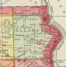
Dorchester is an unincorporated community in northwestern Allamakee County, Iowa, United States. It lies along local roads just off Iowa Highway 76, north of the city of Waukon, the county seat of Allamakee County. Its elevation is 738 feet (225 m). The town was originally settled by Harvey Bell and Edmund Bell, and was named after Dorchester, England. Although Dorchester is unincorporated, it has a post office, with the ZIP code of 52140, which opened on 21 May 1857. Dorchester is located in Waterloo Township.

Dewar, Iowa Unincorporated town in Iowa, United States

Dewar is an unincorporated town in eastern Black Hawk County, Iowa, United States. It lies northeast of the city of Waterloo, the county seat of Black Hawk County. Its elevation is 889 feet (271 m). Although Dewar is unincorporated, it has a post office with the ZIP code of 50623, which opened on 25 October 1887.

Killduff, Iowa Unincorporated community in Iowa, United States

Killduff is an unincorporated community in southeastern Jasper County, Iowa, United States. It lies along local roads southeast of the city of Newton, the county seat of Jasper County.

Conroy, Iowa Census-designated place in Iowa, United States

Conroy is an unincorporated community and census-designated place (CDP) in central Iowa County, Iowa, United States. It lies along local roads southeast of the city of Marengo, the county seat of Iowa County. Its elevation is 879 feet (268 m). Conroy has a post office with the ZIP code of 52220, which opened on 5 January 1885. As of the 2010 census the population was 259.

Prole, Iowa Unincorporated community in Iowa, United States

Prole is an unincorporated rural village in northwestern Warren County, Iowa, United States. It lies along Iowa Highway 28 northwest of the city of Indianola, the county seat of Warren County. Its elevation is 978 feet (298 m). Prole has a post office, with the ZIP code of 50229, a cafe, a floral shop and an auto repair shop by way of businesses and services.

Lycurgus, Iowa Unincorporated community in Iowa, United States

Lycurgus is a rural unincorporated community in Allamakee County, Iowa, United States.

Church, Iowa Unincorporated community in Iowa, United States

Church is an unincorporated community in Allamakee County, Iowa, United States.

Plato, Iowa Unincorporated community in Iowa, United States

Plato is an unincorporated community in Cedar County, Iowa, United States. Plato is located at 41°44′17″N91°18′31″W.

Osborne, Iowa Unincorporated community in Iowa, United States

Osborne is an unincorporated community in Clayton County, Iowa, United States.

Hutchins, Iowa Census-designated place in Iowa, United States

Hutchins is an unincorporated community and census-designated place in Hancock County, Iowa, United States. As of the 2010 census the population was 28.

Barney, Iowa Unincorporated community in Iowa, United States

Barney is an unincorporated community in Madison County, Iowa, in the United States.

Elon, Iowa Unincorporated community in Iowa, United States

Elon is an unincorporated community in Allamakee County, Iowa, United States.

Olaf, Iowa Unincorporated community in Iowa, United States

Olaf is an unincorporated community in Wright County, Iowa, United States.

Gunder, Iowa Unincorporated community in Iowa, United States

Gunder is an unincorporated community in Clayton County, Iowa, United States. The Turkey River flows south of Gunder, and Roberts Creek, a tributary, to the north. The county seat of Elkader lies approximately 10 miles to the southeast.

Lyman, Iowa Unincorporated community in Iowa, United States

Lyman is an unincorporated community in Noble Township, Cass County, Iowa, United States. Lyman is located along U.S. Route 71 and Iowa Highway 92, 12 miles (19 km) south of Atlantic.

Bethesda, Iowa Unincorporated community in Iowa, United States

Bethesda is an unincorporated community in Douglas Township, Page County, Iowa, United States. Bethesda is located along county highways M63 and J20, 7.7 miles (12.4 km) north-northwest of Clarinda.

Ladoga, Iowa Unincorporated community in Iowa, United States

Ladoga is an unincorporated community in Washington Township, Taylor County, Iowa, United States. Ladoga is located along County Route J35, 3 miles (4.8 km) west-southwest of Gravity.

Lacelle, Iowa Unincorporated community in Iowa, United States

Lacelle is an unincorporated community in Knox Township, Clarke County, Iowa, United States. Lacelle is located along County Highway R25, 7.7 miles (12.4 km) southwest of Osceola.

References

  1. U.S. Geological Survey Geographic Names Information System: Maud, Iowa
  2. Ellery M. Hancock (1913). Past and Present of Allamakee County, Iowa: A Record of Settlement, Organization, Progress and Achievement. S. J. Clarke publishing Company. pp.  261.
  3. Cram's Modern Atlas: The New Unrivaled New Census Edition. J. R. Gray & Company. 1902. pp. 203–207.
  4. Company, Rand McNally and (1925). Premier Atlas of the World: Containing Maps of All Countries of the World, with the Most Recent Boundary Decisions, and Maps of All the States,territories, and Possessions of the United States with Population Figures from the Latest Official Census Reports, Also Data of Interest Concerning International and Domestic Political Questions. Rand McNally & Company. p. 190.