Canton is an unincorporated community in Jackson and Jones counties, Iowa, United States. There is a restaurant there, and no other businesses or services.

Granite is an unincorporated community in Lyon County, Iowa, United States, near the historic Blood Run Site and the Gitchie Manitou State Preserve.
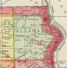
Dorchester is an unincorporated community in northwestern Allamakee County, Iowa, United States. It lies along local roads just off Iowa Highway 76, north of the city of Waukon, the county seat of Allamakee County. Its elevation is 738 feet (225 m). The town was originally settled by Harvey Bell and Edmund Bell, and was named after Dorchester, England. Although Dorchester is unincorporated, it has a post office, with the ZIP code of 52140, which opened on 21 May 1857. Dorchester is located in Waterloo Township.
Dewar is an unincorporated town in eastern Black Hawk County, Iowa, United States. It lies northeast of the city of Waterloo, the county seat of Black Hawk County. Its elevation is 889 feet (271 m). Although Dewar is unincorporated, it has a post office with the ZIP code of 50623, which opened on 25 October 1887.
Prole is an unincorporated rural village in northwestern Warren County, Iowa, United States. It lies along Iowa Highway 28 northwest of the city of Indianola, the county seat of Warren County. Its elevation is 978 feet (298 m). Prole has a post office, with the ZIP code of 50229, a cafe, a floral shop and an auto repair shop by way of businesses and services.
Lycurgus is a rural unincorporated community in Allamakee County, Iowa, United States.
Church is an unincorporated community in Allamakee County, Iowa, United States.
Maple Hill is an unincorporated community in Emmet County, Iowa, United States.
Stilson is an unincorporated community in Hancock County, Iowa, United States.
Hutchins is an unincorporated community and census-designated place in Hancock County, Iowa, United States. As of the 2010 census the population was 28.
Barney is an unincorporated community in Madison County, Iowa, in the United States.
Waukon Junction is an unincorporated community in Allamakee County, Iowa, United States.
Maud is an unincorporated community in Allamakee County, Iowa, United States.
Elon is an unincorporated community in Allamakee County, Iowa, United States.
Dean is an unincorporated community in Appanoose County, Iowa, United States.
Boyer is an unincorporated community in Crawford County, in the U.S. state of Iowa.
Thorpe is an unincorporated community in Honey Creek Township, Delaware County, Iowa, United States.
Quandahl is an unincorporated community in Allamakee County, Iowa, United States.
Village Creek is an unincorporated community in Allamakee County, Iowa, United States.
Astor was an unincorporated community in Crawford County, in the U.S. state of Iowa.