Maupertus-sur-Mer Airfield

Last updated

Maupertus-sur-Mer Airfield
Advanced Landing Ground (ALG) A-15
Manche, Basse-Normandie Region, France
422d Night Fighter Squadron P-61 Black Widow 42-5565.jpg
A P-61 Black Widow (serial number 42-5565) nicknamed "Double Trouble" of the 422nd Night Fighter Squadron over Cherbourg, France
France location map-Regions and departements-2016.svg
Red pog.svg
Maupertus-sur-Mer Airfield
Coordinates 49°39′03″N001°28′31″W / 49.65083°N 1.47528°W / 49.65083; -1.47528 (A-15 Maupertus)
TypeMilitary Airfield
Site information
Controlled by Roundel of France.svg   French Air Force
Regulation WW II Upperwing Balkenkreuz.png   Luftwaffe
Us army air corps shield.svg   United States Army Air Forces
Site history
Built1937
Built byFrench Air Force
Rebuilt by: IX Engineering Command
In use1937 July–September 1944
MaterialsGrass
Later: Prefabricated Hessian Surfacing (PHS)
Battles/wars European-African-Middle Eastern Campaign Streamer.jpg
World War II - EAME Theater
  • Battle of France (1940)
  • Occupation of France (1940-1944)
  • Normandy Campaign
  • Northern France Campaign
Garrison information
Garrison Patch9thusaaf.png   Ninth Air Force
Occupants
  • 422d Night Fighter Squadron
  • 387th Bombardment Group
  • 363d Fighter Group
Airfield information
Elevation459 ft / 140 m AMSL
Runways
Direction Length and surface
17/355,000 feet (1,520 m) SMT/PSP
10/286,000 feet (1,830 m) SMT/PSP
Two Runways, 4 alert pads, 50 hardstands [1]
Major Evan Mc Call and P-51D 44-13309 "Fools Paradise IV". of the 363d Fighter Group 363d Fighter Group P-51D 44-13309.jpg
Major Evan Mc Call and P-51D 44-13309 "Fools Paradise IV". of the 363d Fighter Group
A B-26 Marauder (KS-R, serial number 41-31707) nicknamed "Five By Fives" of the 557th Bomb Squadron, 387th Bomb Group. 387th Bombardment Group 557th BS B-26 41-31707.jpg
A B-26 Marauder (KS-R, serial number 41-31707) nicknamed "Five By Fives" of the 557th Bomb Squadron, 387th Bomb Group.

Maupertus-sur-Mer Airfield is a former World War II military airfield, which is located near the city of Cherbourg-Octeville in the Manche department of Lower Normandy in northwestern France. [1]

Contents

The facility was built as a French military airfield in 1937 before World War II. Used by the Germans during the Occupation of France, it was seized by the United States Army on 27 June 1944 during the Normandy Campaign. [1]

Reconstructed by the IX Engineering Command, 850th Engineer Aviation Battalion, it was used as a combat airfield. After the war, it was returned to the French government, and today it is the civil Cherbourg – Maupertus Airport. [1]

History

The airfield was built by the French Air Force in 1937 as an annex to the military airfield at Querqueville. It consisted of a 1,000m grass runway. In 1939, a concrete perimeter track was added, and on 9 May 1940, it was equipped with Bloch MB.155 fighter aircraft. [1]

During the 1940 Battle of France, the aircraft assigned did not engage in any combat, and it was seized by the occupying German Army in June. It was turned over to the Luftwaffe which assigned Junkers Ju 87 attack aircraft of Jagdgeschwader 2 (JG-2) to the field. During the Dieppe Raid of August 1942, Ju 87s from Maupertus attacked the raiding Allied forces. In the fall of 1942, the Luftwaffe moved the aircraft to the east, and replaced them with six 88mm flak guns, used for anti-aircraft defense of the area. [1]

After the Allied landings in France during June 1944, the United States Army VII Corps reached the airfield on 21 June. The 4th Infantry Division, with the support of the 70th Tank Battalion captured the airfield on 27 June. [1] The 4th's 22nd Regiment moved on the airport from the south and east at 1100 hours on D+20 (June 26), with the three battalions abreast and a troop of cavalry protecting each flank. Heavy fire from enemy antiaircraft guns held up all three battalions for several hours, but, with the aid of supporting fire from the 44th Field Artillery Battalion, the 1st Battalion took a series of positions south of the airport and captured Gonneville, the 2nd Battalion occupied the western edge of the field, and the 3rd Battalion captured Maupertus and the defenses along the northern side of the field.

The enemy, however, continued to offer determined resistance and not until the following day was the airfield finally taken. Designated ALG (Advanced Landing Ground) A-15, the airport became operational a few days later by the 834th Aviation Engineers, IX Engineer Command. 850th Engineer Aviation Battalion and 877th Airborne Engineer Aviation Battalion.

Known as Advanced Landing Ground "A-15", the airfield consisted of a 6000' (1800m) Pierced Steel Planking (PSP) runway aligned 11/29. A secondary PSP 5000' (1500m) runway was also laid down aligned 17/35. In addition, tents were used for billeting and also for support facilities; an access road was built to the existing road infrastructure; a dump for supplies, ammunition, and gasoline drums, along with a drinkable water and minimal electrical grid for communications and station lighting. [2]

The 363d Fighter Group with P-47 Thunderbolts moved into Maupertus on 9 July. Planes began taking off and landing despite the fact that stacked along the main runway was a pile of bombs, live shells, duds, and 600 mines lifted from the airfield. The fighter planes flew support missions during the Allied invasion of Normandy, patrolling roads in front of the beachhead; strafing German military vehicles and dropping bombs on gun emplacements, anti-aircraft artillery and concentrations of German troops in Normandy and Brittany when spotted. The bombers also attacked bridges and German-controlled airfields in occupied areas.

Prime Minister Churchill landed at A-15 on July 20 as did General Charles de Gaulle on August 20.

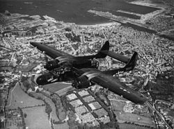
On 22 August, the B-26 Marauder 387th Bombardment Group replaced the 363d. In addition to the bombers the 422d Night Fighter Squadron, equipped with the P-61 Black Widow night interceptor used the airfield until the end of August 1944. [3]

After the Americans moved east into Central France with the advancing Allied Armies, the airfield was used as a resupply and casualty evacuation airfield for several months, before being closed on 22 December 1944. It was then turned over to French authorities. [4]

Major units assigned

380th (A8), 381st (B3), 382d (C3) Fighter Squadrons (P-51D) [3]
556th (FW), 557th (KS), 558th (KX), 559th (TQ) Bombardment Squadrons (B-26) [3]

Postwar use

During the reconstruction of France in the late 1940s, a civil airport was established at the site. During the Cold War, in the 1950s, a modern concrete jet runway for NATO aircraft was laid down by the United States using French contractors, along with a circular marguerite system of dispersal hardstands that could be revetted later with earth for added protection. The Cold War air base was never used and was abandoned when France pulled out of the NATO central command structure in 1967.

The remains of the World War II main (11/29) runway are still visible just to the south of the current airport runway. Also a part of the secondary runway was reused as a taxiway to the now aircraft parking area to the south of the runway. The Cold War-era marguerite hardstands appear to be well-maintained, their use being undetermined.

A memorial to the men and units that were stationed at Maupertus-sur-Mer Airfield is located at the front of the terminal building at Cherbourg-Maupertus Airport. It has the shape of an obelisk, on each of its faces are identified land built at that time (A1 to A26), the Fighters wings, groups Fighters, Bombs groups, Liaison Squadron who were based in Normandy, and the Air Engineers Battalions who participated in the construction of land. [1]

See also

Related Research Articles

<span class="mw-page-title-main">RAF Nuthampstead</span>

Royal Air Force Nuthampstead or more simply RAF Nuthampstead is a former Royal Air Force station in England. The airfield is located mostly in Hertfordshire between the villages of Nuthampstead and Anstey and the hamlet of Morrice Green in Hertfordshire and Langley, Lower Green and Clavering Park Wood in Essex. The eastern part of the airfield including part of the East-West Runway, the Fuel Store, the dispersal areas of 600 and 601 Squadrons and the northeastern perimeter track were all in Essex. RAF Nuthampstead is located four miles to the east of the A10 Hertford to Royston road.

<span class="mw-page-title-main">RAF Stoney Cross</span> Former RAF airfield in Hampshire, England

Royal Air Force Stoney Cross or more simply RAF Stoney Cross is a former Royal Air Force station in the New Forest, Hampshire, England. The airfield is located approximately 4 miles (6.4 km) northwest of Lyndhurst and 12 miles (19 km) west of Southampton.

<span class="mw-page-title-main">RAF Gosfield</span> Airport in Braintree, Essex

Royal Air Force Gosfield or more simply RAF Gosfield is a former Royal Air Force station in Essex, England. The airfield is located approximately 5 miles (8.0 km) north of Braintree; about 40 miles (64 km) north-northeast of London

Cherbourg – Maupertus Airport or Aéroport de Cherbourg - Maupertus is an airport located 11 km east of Cherbourg-en-Cotentin, between Maupertus-sur-Mer and Gonneville. These are all communes of the Manche département in the Normandy région of France. The airport is managed by SNC-Lavalin Airports since 1 October 2009.

<span class="mw-page-title-main">Advanced Landing Ground</span> Temporary advance airfields during World War II

Advanced Landing Grounds (ALGs) were temporary advance airfields constructed by the Allies during World War II during the liberation of Europe. They were built in the UK prior to the invasion and thereafter in northwest Europe from 6 June 1944 to V-E Day, 7 May 1945.

<span class="mw-page-title-main">RAF Staplehurst</span>

Royal Air Force Staplehurst or more simply RAF Staplehurst is a former Royal Air Force Advanced Landing Ground located in Kent, England. The airfield is located approximately 1 mile (1.6 km) northeast of Staplehurst; about 38 miles (61 km) southeast of London.

<span class="mw-page-title-main">Nancy – Ochey Air Base</span> Airport in Ochey, Meurthe-et-Moselle

Nancy-Ochey Air Base is a front-line French Air and Space Force base located approximately 11 km west-southwest of Neuves-Maisons in the Département de Meurthe-et-Moselle, France.

<span class="mw-page-title-main">Saint-Simon – Clastres Air Base</span>

Saint-Simon – Clastres Air Base is an abandoned military airfield, which is located approximately 3 km (2 NM) northwest of Clastres and east of Saint-Simon, both communes in the Aisne department of the Picardy (Picardie) region in France. It is approximately 116 km (63 NM) north-northeast of Paris.

<span class="mw-page-title-main">Azeville Airfield</span>

Azeville/Fontenay (Azeville) Airfield is an abandoned World War II military airfield, which is located near the commune of Azeville in the Normandy region of northern France.

<span class="mw-page-title-main">Cardonville Airfield</span> World War II military airfield

Cardonville Airfield is an abandoned World War II military airfield located near the commune of Cardonville in the Normandy region of northern France.

<span class="mw-page-title-main">Saint-Lambert Airfield</span>

Saint-Lambert Airfield is an abandoned World War II military airfield, which is located near the commune of Saint-Lambert in the Normandy region of northern France.

<span class="mw-page-title-main">Lignerolles Airfield</span>

Lignerolles Airfield is an abandoned World War II military airfield near the commune of Lignerolles in the Normandy region of northern France.

<span class="mw-page-title-main">Gael Airfield</span>

Gael Airfield is an abandoned World War II military airfield, which is located near the commune of Gaël in the Brittany region of northern France.

<span class="mw-page-title-main">Vannes Airport</span> Airport in Meucon, France

Vannes Airport is a regional airport in France. It supports general aviation.

<span class="mw-page-title-main">Chartres – Champhol Aerodrome</span> Airport

Chartres – Champhol Aerodrome is an airport serving Chartres and Champhol, in the Eure-et-Loir department in north-central France. The airport is located 2.5 km (1.3 NM) east-northeast of Chartres and it is southeast of Champhol. It supports general aviation with no commercial airline service scheduled.

Lonray Airfield is an abandoned World War II military airfield, which is located near the commune of Lonrai in the Orne region of northern France.

Laon-Athies Air Base is an abandoned military airfield, which is located near the city of Laon in the Aisne department of France.

<span class="mw-page-title-main">Peronne-St Quentin Airfield</span> Airport in Estress Mons, France

Péronne-St Quentin Airfield is a recreational aerodrome in France, located 11 miles (18 km) west of Saint-Quentin; 121 miles (195 km) north of Paris. It supports general aviation with no commercial airline service scheduled.

<span class="mw-page-title-main">Cambrai-Niergnies Airport</span> Airport in Cambrai, France

Cambrai-Niergnies Airport is a regional airport in France, located 3 miles (4.8 km) south-southeast of Cambrai; 100 miles (160 km) north-northeast of Paris.

Saint-Laurent-sur-Mer is an abandoned World War II military airfield, which is located near the commune of Saint-Laurent-sur-Mer in the Normandy region of northern France.

References

PD-icon.svg This article incorporates public domain material from the Air Force Historical Research Agency

  1. 1 2 3 4 5 6 7 8 Maupertus-sur-Mer Airfield
  2. IX Engineer Command ETO Airfields, Airfield Layout
  3. 1 2 3 4 Maurer, Maurer. Air Force Combat Units of World War II. Maxwell AFB, Alabama: Office of Air Force History, 1983. ISBN   0-89201-092-4.
  4. Johnson, David C. (1988), U.S. Army Air Forces Continental Airfields (ETO), D-Day to V-E Day; Research Division, USAF Historical Research Center, Maxwell AFB, Alabama.