
The Ohio River is a 981-mile (1,579 km) long river in the midwestern United States that flows southwesterly from western Pennsylvania south of Lake Erie to its mouth on the Mississippi River at the southern tip of Illinois. It is the second largest river by discharge volume in the United States and the largest tributary by volume of the north-south flowing Mississippi River that divides the eastern from western United States. The river flows through or along the border of six states, and its drainage basin includes parts of 15 states. Through its largest tributary, the Tennessee River, the basin includes several states of the southeastern U.S. It is the source of drinking water for three million people.
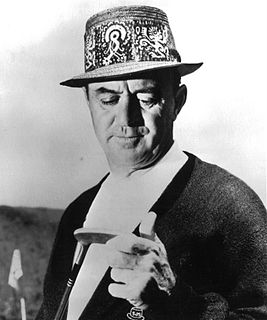
Samuel Jackson Snead was an American professional golfer who was one of the top players in the world for the better part of four decades and one of the greatest players of all time. Snead won a record 82 PGA Tour events, including seven majors. He never won the U.S. Open, though he was runner-up four times.
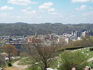
Charleston is the most populous city in, and the capital of, the U.S. state of West Virginia. Located at the confluence of the Elk and Kanawha rivers, the population during the 2017 Census Estimate was 47,929. The Charleston metropolitan area as a whole had 214,406 residents. Charleston is the center of government, commerce, and industry for Kanawha County, of which it is the county seat.

The Potomac River is located within the Mid-Atlantic region of the United States and flows from the Potomac Highlands into the Chesapeake Bay. The river is approximately 405 miles (652 km) long, with a drainage area of about 14,700 square miles (38,000 km2). In terms of area, this makes the Potomac River the fourth largest river along the Atlantic coast of the United States and the 21st largest in the United States. Over 5 million people live within the Potomac watershed.

The Shenandoah Valley is a geographic valley and cultural region of western Virginia and the Eastern Panhandle of West Virginia in the United States. The valley is bounded to the east by the Blue Ridge Mountains, to the west by the eastern front of the Ridge-and-Valley Appalachians, to the north by the Potomac River and to the south by the James River. The cultural region covers a larger area that includes all of the valley plus the Virginia highlands to the west, and the Roanoke Valley to the south. It is physiographically located within the Ridge and Valley province and is a portion of the Great Appalachian Valley.

West Virginia University (WVU) is a public, land-grant, space-grant, research-intensive university in Morgantown, West Virginia, United States. Its other campuses include the West Virginia University Institute of Technology in Beckley and Potomac State College of West Virginia University in Keyser; and a second clinical campus for the University's medical and dental schools at Charleston Area Medical Center in Charleston. WVU Extension Service provides outreach with offices in all of West Virginia's 55 counties. Since 2001, WVU has been governed by the West Virginia University Board of Governors.

The Allegheny Mountain Range, informally the Alleghenies and also spelled Alleghany and Allegany, is part of the vast Appalachian Mountain Range of the Eastern United States and Canada and posed a significant barrier to land travel in less technologically advanced eras. The barrier range has a northeast–southwest orientation and runs for about 400 miles (640 km) from north-central Pennsylvania, through western Maryland and eastern West Virginia, to southwestern Virginia.

"Take Me Home, Country Roads", also known as "Take Me Home" or "Country Roads", is a song written by Bill Danoff, Taffy Nivert, and John Denver about the state of West Virginia. It was released as a single performed by Denver on April 12, 1971, peaking at number 2 on Billboard's US Hot 100 singles for the week ending August 28, 1971. The song was a success on its initial release and was certified Gold by the RIAA on August 18, 1971, and Platinum on April 10, 2017. The song became one of John Denver's most popular and beloved songs. It has continued to sell, with over 1.5 million digital copies sold in the United States. It is considered to be Denver's signature song.
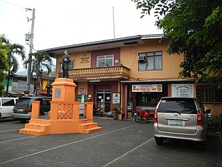
Rizal, officially the Municipality of Rizal,, is a 5th class municipality in the province of Laguna, Philippines. According to the 2015 census, it has a population of 17,253 people.

This is a list of properties and historic districts in West Virginia that are listed on the National Register of Historic Places. There are listings in every one of West Virginia's 55 counties.

State Road 2 is a former east–west state highway in the Arkansas Timberlands and Lower Arkansas Delta. The route was approximately 195 miles (314 km), and ran from US Route 67 (US 67) in Texarkana east to cross the Mississippi River near Lake Village, continuing as Mississippi Highway 10. On July 1, 1931, the route was entirely replaced by US Highway 82 (US 82) by the American Association of State Highway Officials (AASHTO). The route was maintained by the Arkansas Highway Department (AHD), now known as the Arkansas Department of Transportation (ArDOT).

The Huntington–Ashland metropolitan area is the largest metropolitan statistical area in West Virginia and includes seven counties across three states: West Virginia, Kentucky, and Ohio. New definitions from February 28, 2013 placed the population at 361,580. The MSA is nestled along the banks of the Ohio River within the Appalachian Plateau region. The area is referred to locally as the "Tri-State area". In addition, the three largest cities are referred to as the River Cities.

Pinoy Box Office is a Philippine television film channel owned and operated by Viva Entertainment.

Helen's Babies is a 1924 silent comedy film directed by William A. Seiter, based on the 1876 novel Helen's Babies by John Habberton.
Mayton Eugenio,, is a Filipina commercial model, actress and dancer. She is well-known as the daughter of veteran choreographer and one of the Philippines' famous dance icons, Geleen Eugenio, and has been cast in various roles such as Weng Dimagiba in the horror-thriller series Dormitoryo in GMA Network.
Charles Mayton is a New York-based painter. His work combines painterly abstraction with the iconography of digital media. Mayton’s visual strategies of appropriation and détournement have been compared to the appropriation art of the Pictures Generation.


