
Webster County is a county in the U.S. state of West Virginia. As of the 2010 census, the population was 9,154. Its county seat is Webster Springs. The county was founded in 1860 and named for Daniel Webster.

Addison, commonly known as Webster Springs, is a town in and the county seat of Webster County, West Virginia, United States. Although it was incorporated as Addison in 1892, it is more frequently referred to as Webster Springs, the name of the town's post office. It was named for Addison McLaughlin, upon whose land the town was originally laid out. The population was 776 at the 2010 census.

Webster is an unincorporated community in Taylor County, West Virginia, United States. It lies four miles south of Grafton. Its elevation is 1,019 feet above sea level.
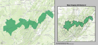
West Virginia's 2nd congressional district stretches from the Ohio River border with Ohio to the Potomac River border with Maryland and the border with Virginia. It includes the capital city of Charleston and the rapidly growing residential communities of West Virginia's Eastern Panhandle and Potomac Highlands regions connected by a narrow strip of nearly unpopulated counties. It is 20 miles (32 km) wide and 300 miles (480 km) long.

West Virginia's 3rd congressional district is a U.S. congressional district in southern West Virginia. The district covers the state's second largest city, Huntington, includes Bluefield, Princeton and Beckley, and has a long history of coal mining, forestry and farming.

Charles Phillips Dorr was a lawyer and Republican politician from West Virginia who served as a United States Representative in the 55th United States Congress. Dorr was born in Miltonsburg, Ohio in Monroe County.
The Mountain Parkway Byway and Mountain Parkway Backway are two routes in northern Webster County, West Virginia. The Byway is a state-designated scenic byway which follows West Virginia Route 20 for 9.8 miles (15.8 km), traversing the headwaters of several mountain streams including the Right Fork Little Kanawha River, Jerry Run, and the Left and Laurel Forks of Holly River. The Backway explores backroads in the same area, is 32 miles (51 km) long, and follows stretches of the Right Fork Little Kanawha River and Left Fork Holly River for portions of its route.

This is a list of the National Register of Historic Places listings in Webster County, West Virginia.
Donaldson is an unincorporated community in Webster County, West Virginia, United States. Donaldson is located on the Gauley River at County Route 46, 2.9 miles (4.7 km) east-southeast of Cowen.

Dyer is an unincorporated community in Webster County, West Virginia, United States. Dyer is located on the Williams River and County Route 46, 4.9 miles (7.9 km) east-southeast of Cowen.
Curtin is an unincorporated community in Webster County, West Virginia, United States. Curtin is located along the Elk River, 2.6 miles (4.2 km) east of Webster Springs.
Guardian is an unincorporated community in Webster County, West Virginia, United States. Guardian is located along the Right Fork Holly River and West Virginia Route 15, 11.4 miles (18.3 km) north-northwest of Webster Springs. Guardian had a post office, which closed on February 1, 1988. The community took its name from the local Guardian Coal and Oil Company. Guardian was previously known as Removal from about the 1880s until 1937 when the post office named changed to Guardian. Guardian was also referred to as Middleport in early postal records. The history of the town is exhaustively set out in a two volume book set known as "Removal Reflections: A History of Guardian/Removal, West Virginia."
Replete is an unincorporated community in Webster County, West Virginia, United States. Replete is located on County Route 3, 15.7 miles (25.3 km) north-northwest of Webster Springs. Replete had a post office, which closed on January 21, 1989. An early variant name was Mount Pleasant.
Parcoal is an unincorporated community in Webster County, West Virginia, United States. Parcoal is located along the Elk River, 2.3 miles (3.7 km) east-southeast of Webster Springs. Parcoal had a post office, which closed on November 26, 1988.

The 2012 United States presidential election in West Virginia took place on November 6, 2012, as part of the 2012 United States presidential election in which all 50 states plus the District of Columbia participated. West Virginia voters chose five electors to represent them in the Electoral College via a popular vote pitting incumbent Democratic President Barack Obama and his running mate, Vice President Joe Biden, against Republican challenger and former Massachusetts Governor Mitt Romney and his running mate, Congressman Paul Ryan.
Weese is an unincorporated community in Randolph County, West Virginia.
Weese, West Virginia may refer to:

The Webster Sycamore was an American sycamore in the U.S. state of West Virginia. Long recognized for its size, the Webster Sycamore was the largest living American sycamore tree in West Virginia until its felling in 2010. The tree stood approximately 4.5 miles (7.2 km) east of Webster Springs in Webster County, in a moist flood plain along the banks of the Back Fork Elk River, a tributary stream of the Elk River.


