Sakhir is a desert area located in the Southern Governorate of the Kingdom of Bahrain, near Zallaq. It contains the Al-Sakhir Palace, built in 1870.

Lubnów is a village in the administrative district of Gmina Ziębice, within Ząbkowice Śląskie County, Lower Silesian Voivodeship, in south-western Poland. Prior to 1945 it was in Germany. It lies approximately 10 kilometres (6 mi) south of Ziębice, 18 km (11 mi) south-east of Ząbkowice Śląskie, and 68 km (42 mi) south of the regional capital Wrocław.
Małaszewicze Duże is a village in the administrative district of Gmina Terespol, within Biała Podlaska County, Lublin Voivodeship, in eastern Poland, close to the border with Belarus. It lies approximately 7 kilometres (4 mi) south-west of Terespol, 28 km (17 mi) east of Biała Podlaska, and 109 km (68 mi) north-east of the regional capital Lublin.
Sielec is a village in the administrative district of Gmina Leśniowice, within Chełm County, Lublin Voivodeship, in eastern Poland. It lies approximately 7 kilometres (4 mi) north-east of Leśniowice, 14 km (9 mi) south of Chełm, and 71 km (44 mi) east of the regional capital Lublin.
Sędziejowice is a village in Łask County, Łódź Voivodeship, in central Poland. It is the seat of the gmina called Gmina Sędziejowice. It lies approximately 11 kilometres (7 mi) south-west of Łask and 43 km (27 mi) south-west of the regional capital Łódź.
Zarzecze is a village in the administrative district of Gmina Wolbrom, within Olkusz County, Lesser Poland Voivodeship, in southern Poland. It lies approximately 7 kilometres (4 mi) south-west of Wolbrom, 14 km (9 mi) north-east of Olkusz, and 38 km (24 mi) north-west of the regional capital Kraków.
Gózd is a village in the administrative district of Gmina Harasiuki, within Nisko County, Subcarpathian Voivodeship, in south-eastern Poland. It lies approximately 6 kilometres (4 mi) north-west of Harasiuki, 21 km (13 mi) east of Nisko, and 62 km (39 mi) north-east of the regional capital Rzeszów.
Wolica is a village in the administrative district of Gmina Gać, within Przeworsk County, Subcarpathian Voivodeship, in south-eastern Poland. It lies approximately 5 kilometres (3 mi) east of Gać, 8 km (5 mi) south-west of Przeworsk, and 30 km (19 mi) east of the regional capital Rzeszów.
Jagiełła is a village in the administrative district of Gmina Tryńcza, within Przeworsk County, Subcarpathian Voivodeship, in south-eastern Poland. It lies approximately 8 kilometres (5 mi) south of Tryńcza, 7 km (4 mi) north-east of Przeworsk, and 41 km (25 mi) east of the regional capital Rzeszów.
Łapajówka is a village in the administrative district of Gmina Zarzecze, within Przeworsk County, Subcarpathian Voivodeship, in south-eastern Poland. It lies approximately 3 kilometres (2 mi) north-west of Zarzecze, 8 km (5 mi) south of Przeworsk, and 37 km (23 mi) east of the regional capital Rzeszów.
Parcelacja Rożniatowska is a village in the administrative district of Gmina Zarzecze, within Przeworsk County, Subcarpathian Voivodeship, in south-eastern Poland. It lies approximately 2 kilometres (1 mi) south-west of Zarzecze, 11 km (7 mi) south of Przeworsk, and 38 km (24 mi) east of the regional capital Rzeszów.
Pełnatycze is a village in the administrative district of Gmina Zarzecze, within Przeworsk County, Subcarpathian Voivodeship, in south-eastern Poland. It lies approximately 3 kilometres (2 mi) south-east of Zarzecze, 12 km (7 mi) south of Przeworsk, and 40 km (25 mi) east of the regional capital Rzeszów.
Rożniatów is a village in the administrative district of Gmina Zarzecze, within Przeworsk County, Subcarpathian Voivodeship, in south-eastern Poland. It lies approximately 10 km (6 mi) south of Przeworsk and 39 km (24 mi) east of the regional capital Rzeszów.
Siennów is a village in the administrative district of Gmina Zarzecze, within Przeworsk County, Subcarpathian Voivodeship, in south-eastern Poland. It lies approximately 4 kilometres (2 mi) south-west of Zarzecze, 12 km (7 mi) south of Przeworsk, and 37 km (23 mi) east of the regional capital Rzeszów.
Zalesie Żurowskie is a village in the administrative district of Gmina Zarzecze, within Przeworsk County, Subcarpathian Voivodeship, in south-eastern Poland.
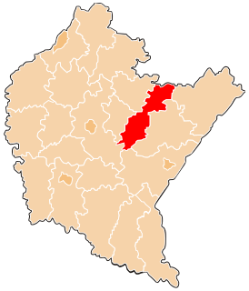
Zarzecze is a village in Przeworsk County, Subcarpathian Voivodeship, in south-eastern Poland. It is the seat of the gmina called Gmina Zarzecze. It lies approximately 10 kilometres (6 mi) south of Przeworsk and 39 km (24 mi) east of the regional capital Rzeszów.
Żurawiczki is a village in the administrative district of Gmina Zarzecze, within Przeworsk County, Subcarpathian Voivodeship, in south-eastern Poland. It lies approximately 4 kilometres (2 mi) north-west of Zarzecze, 6 km (4 mi) south of Przeworsk, and 37 km (23 mi) east of the regional capital Rzeszów.
Grzęska is a village in the administrative district of Gmina Przeworsk, within Przeworsk County, Subcarpathian Voivodeship, in south-eastern Poland. It lies approximately 3 kilometres (2 mi) west of Przeworsk and 34 km (21 mi) east of the regional capital Rzeszów.
Kępa Rzeczycka is a village in the administrative district of Gmina Radomyśl nad Sanem, within Stalowa Wola County, Subcarpathian Voivodeship, in south-eastern Poland. It lies approximately 7 kilometres (4 mi) south-east of Radomyśl nad Sanem, 8 km (5 mi) north of Stalowa Wola, and 69 km (43 mi) north of the regional capital Rzeszów.