McKnight, Texas

Last updated
McKnight, Texas
USA Texas location map.svg
Red pog.svg
McKnight
Usa edcp location map.svg
Red pog.svg
McKnight
Coordinates: 32°00′16″N94°54′21″W / 32.00444°N 94.90583°W / 32.00444; -94.90583
Country United States
State Texas
County Rusk
Elevation
[1]
384 ft (117 m)
Time zone UTC-6 (Central (CST))
  Summer (DST) UTC-5 (CDT)
GNIS feature ID1378657 [1]

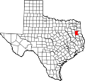
McKnight is an unincorporated community in Rusk County, Texas, United States. [1] It is located at the junction of Farm to Market Road 839 and Farm to Market Road 1798. [2]

See also

Related Research Articles

<span class="mw-page-title-main">Farm to Market Road 1472</span>

Farm to Market Road 1472 (FM 1472) is a farm-to-market road in the U.S. state of Texas that connects the industrial area of Laredo to the Laredo–Colombia Solidarity International Bridge, and then runs roughly parallel to the Rio Grande into rural Webb County. In the urban sections of Laredo, it is a six-lane route known locally as Mines Road.

Bleiblerville is an unincorporated community in northern Austin County, Texas, United States. According to the Handbook of Texas, its population was 71 in 2000. It is located within the Greater Houston metropolitan area.

<span class="mw-page-title-main">Farm to Market Road 1528</span> Road in Texas

Farm to Market Road 1528 is a farm-to-market road located in the western and central portions of Delta County in the U.S. state of Texas. The highway is approximately 11.4 miles (18.3 km) in length, and travels from FM 64 in the community of Antioch to SH 154 in the county seat of Cooper.

<span class="mw-page-title-main">Stringfellow Unit</span>

The A. M. "Mac" Stringfellow Unit is a Texas Department of Criminal Justice prison located in unincorporated Brazoria County, Texas, with a Rosharon, Texas postal address it is not inside the Rosharon census-designated place. The prison is located on Farm to Market Road 655, 4 miles (6.4 km) west of Farm to Market Road 521, and about 30 miles (48 km) south of Houston. The unit is co-located with the Ramsey Unit and the Terrell Unit on a 16,369-acre (6,624 ha) plot of land.

<span class="mw-page-title-main">Elm Grove, Wharton County, Texas</span> Unincorporated community in Texas, United States

Elm Grove is an unincorporated community at the northern edge of Wharton County, in the U.S. state of Texas. The very small community is situated on Farm to Market Road 2614, (FM 2614) to the south of Eagle Lake, which is in Colorado County.

Delmer is an unincorporated community in Cherokee County, Texas, United States. It is located just under one mile (1.6 km) north of the unincorporated community of Oakland, at the western terminus of Farm to Market Road 2972.

References

  1. 1 2 3 U.S. Geological Survey Geographic Names Information System: McKnight
  2. "McKnight, Texas 79237" (Map). Google Maps . Google. September 5, 2024. Retrieved September 5, 2024.