
Nye County is a county in the U.S. state of Nevada. As of the 2020 census, the population was 51,591. Its county seat is Tonopah. At 18,159 square miles (47,030 km2), Nye is Nevada's largest county by area and the third-largest county in the contiguous United States, behind Coconino County of Arizona and San Bernardino County of California.

Esmeralda County is a county in the southwestern portion of the U.S. state of Nevada. As of the 2020 census, the population was 729, making it the least populous county in Nevada. Esmeralda County does not have any incorporated communities. Its county seat is the town of Goldfield.

Tonopah is an unincorporated town in, and the county seat of, Nye County, Nevada, United States. Nicknamed the Queen of the Silver Camps for its mining-rich history, it is now primarily a tourism-based resort city, notable for attractions like the Mizpah Hotel and the Clown Motel.
Goldfield is an unincorporated small desert city and the county seat of Esmeralda County, Nevada.

Death Valley Junction, more commonly known as Amargosa, is a tiny Mojave Desert unincorporated community in Inyo County, California, at the intersection of SR 190 and SR 127, in the Amargosa Valley and just east of Death Valley National Park. The zip code is 92328, the elevation is 2,041 ft (622 m), and the population is fewer than four people.
Esmeralda County School District is a public school district in Esmeralda County, Nevada. It is the smallest school district in Nevada. Its boundary is that of the county. The district has offices in Dyer and Goldfield.

The Tonopah and Tidewater Railroad was a former class II railroad that served eastern California and southwestern Nevada.
Scotty's Junction is an unincorporated community in the Sarcobatus Flat of Nye County, Nevada where State Route 267 meets with U.S. Route 95 at an elevation of 4,062 feet (1,238 m).

Dyer is an unincorporated town, located in Fish Lake Valley, Esmeralda County, Nevada, United States. It had a population of 324 as of the 2018 American Community Survey. The town serves the surrounding area's sparse rural population of mainly ranchers and indigenous Paiute people. The town has a gas station/store, cafe, post office and airport.

Silver Peak is an unincorporated community and census-designated place (CDP) in Esmeralda County, Nevada, United States. It lies along State Route 265, 20 miles (32 km) south of U.S. Route 6 and 30 miles (48 km) west of Goldfield, the county seat of Esmeralda County. It has a post office, with the ZIP code of 89047. The population of Silver Peak was 142 as of 2019.
Coaldale is a former mining town and true ghost town in Esmeralda County, Nevada, located at the junction of U.S. Route 6 and U.S. Route 95 about 40 miles (64 km) west of Tonopah.
Blair, Nevada is a mining ghost town in Esmeralda County, Nevada.

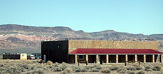
Millers is a ghost town located in Esmeralda County, Nevada. Deserted today, Millers sprang up as a mining boomtown after the Tonopah boom began. A highway rest-stop is located there, resulting in Millers still being listed on many travel maps.

U.S. Route 6 (US 6) is a United States Numbered Highway, stretching from Bishop, California, in the west to Provincetown, Massachusetts, on the East Coast. The Nevada portion crosses the center of the state, serving the cities of Tonopah and Ely, en route to Utah and points further east. Like US 50, to the north, large desolate areas are traversed by the route, with few or no signs of civilization, and the highway crosses several large desert valleys separated by numerous mountain ranges towering over the valley floors, in what is known as the Basin and Range Province of the Great Basin.

U.S. Route 95 is a major U.S. highway traversing the U.S. state of Nevada from north to south directly through Las Vegas and providing connections to both Carson City and Reno. US 95 is cosigned with Interstate 80 for 95 miles (153 km) between a junction in Trinity and Winnemucca before heading north into Oregon at McDermitt. At 646.71 miles (1,040.78 km), it is the longest highway in Nevada.

The Tonopah and Goldfield Railroad, a railroad of 100.4 miles (161.6 km) in length in the U.S. state of Nevada, offered point-to-point service between Mina and Goldfield, running over the Excelsior Mountains and parallel to the Monte Cristo Range. It operated from 1905 until 1947.
Nye County School District provides public education for all grades in Nye County, Nevada, as well as 6th through 12th grade education for students living in Esmeralda County, due to its school district having no high school. The headquarters of the district are in Tonopah. The district serves 17 schools. The school district also serves 5,933 students with over 322 Administrators & Faculty Members. The N.C.S.D. Motto is Every Child A Success.
Blair Junction is the neglected site of a formerly populated settlement in Esmeralda County, in the U.S. state of Nevada.
Gilbert is a ghost town in Esmeralda County, in the U.S. state of Nevada.
Alkali is a ghost town located in Esmeralda County, Nevada. Alkali is the site of Alkali Hot Spring, which was operated as a spa by Geni and Joe Guisti in the 1930s. During Goldfield's peak, the site included an indoor wooden swimming pool with a separate area for children and a large building containing a dining room, kitchen, dance hall and bar. In front of the dining room were tall tamarisk trees and a large picnic table where visitors could either order from the dining room or bring their own lunches. The Guisti residence was at the rear of the dining room. Geni Guisti served young folks grape juice over ice at the bar, which was considered a real treat. Friday and Saturday night dances were attended by Tonopah residents.


