Mediterranean California

Last updated
Silverado Canyon and chaparral habitat, in the Peninsular Ranges of Southern California. SilveradoCanyon.JPG
Silverado Canyon and chaparral habitat, in the Peninsular Ranges of Southern California.
California oak woodland habitat, of the California chaparral and woodlands ecoregion, in San Luis Obispo County. Quercusagrifolia.jpg
California oak woodland habitat, of the California chaparral and woodlands ecoregion, in San Luis Obispo County.
Redshanks (Adenostoma sparsifolium) and bigpod ceanothus (Ceanothus megacarpus), in chaparral habitat of the Santa Monica Mountains. Adenostoma sparsifolium and Ceanothus megacarpus.jpg
Redshanks (Adenostoma sparsifolium) and bigpod ceanothus (Ceanothus megacarpus), in chaparral habitat of the Santa Monica Mountains.

Mediterranean California is a Level I ecoregion of North America designated by the Commission for Environmental Cooperation (CEC) in its North American Environmental Atlas. The region is present only in California and Baja California.

Contents

Climate

Very few places in the world have the Mediterranean climate of California. It is one of the more rare in the world, with only five locations: the Mediterranean Basin, Southwest Australia, the Cape ProvinceWestern Cape of South Africa, the Chilean Matorral, and the California chaparral and woodlands ecoregion of California and the Baja California Peninsula. The region is typified by warm dry summers and mild wet winters. This is unusual as most climates have more precipitation in the summer. There are three variations to the Mediterranean climate in California, a cool summer/cool winter variation, a cool summer/cool winter with summer fog variation, and a hot summer/cool winter variation. The average temperatures for the cool summer variations are below 71 °F (22 °C) in the summer and between 27–64 °F (−3–18 °C) in the winter. Average summer temperatures for the hot summer variation are above 71 °F (22 °C). Average annual precipitation for this climate is 25–100 inches (640–2,540 mm) per year.

Hydrology

Defined by the Pacific Coast on the west, the Sierra Nevada (mountains) and the deserts of California on the east, and the Northern California Coast Ranges on the north, the Mediterranean California ecoregion has unique physical characteristics that play a large role in the natural systems of the region, including hydrology.

Precipitation

The unusual precipitation pattern of the Mediterranean climate is due to subtropical high-pressure systems in the summer and the polar jet stream in the winter. Rainfall in the summer is uncommon because the marine layer becomes capped with dry sinking air. The marine layer is an air mass over a large body of water brought about by a temperature inversion from the cooling effect of the water on the warmer air. The marine layer is often accompanied by fog. The polar jet stream in the winter brings with it rain and snow. The jet stream is an extremely powerful air current flowing west to east often at over 100 miles per hour.

The precipitation in the region is closely associated with winter frontal storms from the Pacific Ocean, which bring cool air and rain to the area. The annual rainfall varies in different elevations, but the average range is between 400–800 millimetres (16–31 in) annually. Much of the rain in Central and Northern California flows out the Sacramento and San Joaquin Rivers, which with numerous tributaries run through an upper part of the ecoregion.

Fog is also an important aspect of the hydrologic cycle in this ecoregion; the cooling of air over the warm seawater create a dense fog that covers large areas of the coast. This fog affects the vegetation and overall environment on the coast. On the contrary, fire also influences this region. The fire-flood sequence that occurs post-fire can greatly effect populations of species in the region. The combination of the geophysical characteristics, little rainfall, and the bodies of water in the region make it a unique, distinct environment.

Geology

Mediterranean climate California's geology is characterized by the meeting of the North American Plate and Pacific Plate, with much of its region near or influenced by the San Andreas Fault along the junction. When the two plates collided the Pacific Plate was pushed under the North American Plate, and the California Coast Ranges and Sierra Nevada were uplifted. The Coast Ranges are largely metamorphic rock formed from the submergence of the Pacific Plate, and the Sierra are uplifted granite batholiths. Not along the San Andreas Fault, the granitic Peninsular Ranges system also uplifted with the collision, and runs from Southern California, down the Baja California Peninsula, into Baja California Sur state, northwest Mexico. The Transverse Ranges are another major Southern California mountain system primarily in the Mediterranean climate zone. Large earthquakes can do considerable damage to populated areas, and to the state's water, transportation, and energy infrastructure.

The Central Valley of California is a significant feature of Mediterranean climate California. It was an ancient oceanic inlet that eventually sediment filled in, the deposition supplied by erosion of the surrounding mountain ranges. The soil is composed of both the metamorphic, oceanic crust-like Coastal Range sediment and the mineral-rich granitic Sierra sediment. The combination creates very fertile soil. The flatness and fertility of the soil, along with the almost year-round sunshine has attracted much agriculture to the area. As a result, native species no longer dominate the landscape. The southern portion, named the San Joaquin Valley, also produces two-thirds of California’s oil from underground reserves. Fossils are found where adjacent tar pits occur.

California towhee (Pipilo crissalis), in San Luis Obispo. Pipilo crissalis -San Luis Obispo, California, USA-8.jpg
California towhee (Pipilo crissalis), in San Luis Obispo.
Palos Verdes blue (Glaucopsyche lygdamus palosverdesensis), butterfly endemic to the Palos Verdes Peninsula. PVBlue.jpg
Palos Verdes blue (Glaucopsyche lygdamus palosverdesensis), butterfly endemic to the Palos Verdes Peninsula.

Biota

Dominant animal species

The Mediterranean California ecoregion, is well known for its large variety and abundance of animals. One of these important animals is the American golden eagle, which plays a massive role in maintaining the ecoregion’s ecosystem through its top-down predation on smaller, more abundant animals. The golden eagle is considered to be the apex predator of this community, and there are no other species bigger than them on the food chain. Their lifespan can be up to around 30 years in the wild and even longer in captivity. Native to mountain areas and grasslands, California is a great region for this bird of prey to thrive in. The main reason for the golden eagle being a keystone species of this ecoregion is their ability to keep small herbivorous mammal populations in line. "Prairie Dogs, ground squirrels, other rodents, hares, and rabbits, all of which eat grass and seeds, constitute 77.9% of the golden eagles diet." They also are known to prey on animals such as, cranes, black-tailed jack rabbits, swans, deer, coyotes, badgers, mountain goats, bobcats, and various fish species.

Another less popular species, but yet still keystone to this region, is the kangaroo rat. Studies have shown that kangaroo rats play very large roles in maintaining the population sizes and animal diversity throughout the region. Although they are small and on the verge of extinction, these animals play a large role in maintaining plant diversity, which helps the various herbivores with food supply, and also protection for other small animals seeking shelter. kangaroo rats occupy many land habitats ranging from desserts, and grasslands, to chaparral areas making them present in all areas of the Mediterranean California ecoregion. Kangaroo rats like to feed on many various grass seeds, as well as mesquite beans and thus is the reason that plants tend to not grow as well when sharing the same community with these rats. On occasions though, these animals like to feed on green vegetation, and insects. Unfortunately for the rat though, it is preyed upon by many predators. These predators include, owls, snakes, bobcats, foxes, badgers, coyotes, cats and dogs, and many more. Other dominant species in the region include, mountain lions, coyotes, sea otters, brown bears, and various large birds of prey.

Dominant plant communities

California poppy (Eschscholzia californica) field, at the Antelope Valley California Poppy Reserve. AntelopeValleyPoppyReserve 2008 05 04 a.jpg
California poppy (Eschscholzia californica) field, at the Antelope Valley California Poppy Reserve.

The vegetation in the Mediterranean California ecoregion is a mixture of grasses and shrubs called chaparral with some oak forests as well. This area is very highly populated and agriculture is prevalent in the valleys. [1] Evergreen trees and shrubs—such as heaths—mainly dominate Mediterranean vegetation with a shrubby to herbaceous understory. Mediterranean vegetation embodies less than 5% of terrestrial ecosystems around the world. A very important aspect of this ecosystem is its frequent wildfires leading to most of its vegetation adapting fire response mechanisms (Vilà and Sardans 1999). Common shrubs within this region are chamise or greasewood (Adenostoma fasciculatum), manzanita (Arctostaphylos spp.), coast sagebrush (Artemisia californica), and California-lilacs (Ceanothus spp.). [2]

Because the climate is so dry and experiences frequent fires, competition is high among plants within this ecoregion. The Mediterranean community found in southern California is said to have a successional stage after wildfires. The fire leaves patches of bare ground which then are quickly filled with newly germinated seeds. Native and introduced herbs persist for the first year following a fire. Shrubs and subshrubs slowly fill in and hit their peak at four to eight years after the fire. Extinctions, unlike many other communities are frequently the cause of environmental extremes rather than competitive invasive species. [3] Human disturbance can increase wildfires with the introduction of grasses such as Bromus rubens which can be readily established in the newly burned, cleared patches. These grasses are more densely compacted and create more fuel for fires. Agricultural grazing can also greatly decrease the chaparral (tangled shrubby brush habitat), which is the home of many native endemic species. [4] [3]

California condor (Gymnogyps californianus) in flight. Condor in flight.JPG
California condor (Gymnogyps californianus) in flight.
San Joaquin kit fox (Vulpes macrotis subsp. mutica), sitting. Vulpes macrotis mutica sitting.jpg
San Joaquin kit fox (Vulpes macrotis subsp. mutica), sitting.

Endangered species

An endangered species is a species of organisms, either flora or fauna, which face a very high risk of extinction in a proximate time frame, much sooner than the long-term horizon in which species typically persist. There are many species of birds, mammals, reptiles, amphibians and plants that live in the Mediterranean California chaparral and woodlands ecoregion. Yet due to a variety of factors including habitat loss due to the 30 million humans who share the land, some species are endangered.

Endangered, threatened, and vulnerable species of the Mediterranean California chaparral and woodlands ecoregion include:

The California condor (Gymnogyps californianus) is one of the most iconic species in the state. With over a 9 feet (2.7 m) wingspan, condors are the largest flying land bird in North America. They are opportunistic scavengers that prey on large dead mammals. The main factors that led to the species endangered status were settlement of the west, shooting, poisoning from lead and DDT, egg collecting, and general habitat degradation. Serious conservation efforts have been made since the 1960s and this severely endangered species has begun a recovery path. A condor recovery program has been started and a wild population is steadily growing.

Another species is the tiny and secretive San Joaquin kit fox (Vulpes macrotis subsp. mutica) is one of the most endangered animals in California. The kit fox is the size of a cat, with big ears, a long bushy tail and furry toes that help to keep it cool in its hot and dry Californian Mediterranean environment. Biologists state that there are fewer than 7,000 San Joaquin kit foxes. San Joaquin kit fox populations rise and fall with the amount of annual rainfall: more rain means more kit foxes. Changes in precipitation patterns, including reduced rainfall and increase changes of drought, all caused by climate change, would affect San Joaquin kit fox populations. The change in the Central Valley from open grasslands to farms, orchards, houses and roads has most affected San Joaquin kit foxes, causing death, illness, injury, difficulty in finding a mate and difficulty in finding food. These kit foxes also are killed and out competed for resources by coyotes and red foxes. Another threat is poison used to kill rats and mice. A recent decision by the federal government to limit to use of these poisons outdoors may keep kit foxes safe.

Natural resources

Humans have used resources of this ecoregion for many years, dating back to early Native Americans. Some traditional resources that are still used today are in danger of being overharvested. These include the Pacific Ocean fisheries, the dwindling timber industry, the rivers flowing from the mountains and the grasslands. All of these resources are either being over harvested or destroyed through agricultural and industrial development. Grasslands hold many native oak trees that are being lost due to overgrazing or forest fires. The overgrazing is attributed to the increasing number of cattle farms while the forest fires come from the use of natural water for human and agricultural use. As more water is used, oak trees lose out without this key component and fires increase due to drying out of the grasslands and forests. The government has tried to install conservation programs to halter the increased use of the land and waterways, but more must be done to create a truly sustainable environment.

Emerging resources from the region are mainly high value agricultural crops. These include stone fruits, sugar beets, rice, nuts, grapes, cotton and specialized cattle systems. Many of these cannot be grown in other parts of the country and thrive in this type of climate. However, because of the dry seasons, these products require large amounts of water as well as varied chemicals and fertilizers to increase production. Many of these farming enterprises are enormous and not sustainable. They leach out chemicals, bring in mass amounts of inputs, and degrade a lot of the land. As with the traditional resources, the government has implemented conservation programs, but only a limited amount.

Climate change

Climate change in the Mediterranean California ecoregion is expected[ by whom? ] to ultimately have negative effects on the ecosystem and the region's biodiversity. The coast of California is expected to warm by as much as 2 °C in the next 50 years. This is going to cause hotter and drier seasons; the normally wet winters (when a majority of the ecosystem's rain in received) will be drier, and the summers will be especially hotter as well. Increased wildfires will result from the region's warming – mainly in the summer. The shrubbery and trees characteristic of the California chaparral will not fare well in the warmer (and increased fire) region; grasses that are able to regrow asexually or from special off chutes will fare the best. Ultimately the soil quality is going to degrade due to the increased burnings and increased temperatures. Overall, climate change does not bode well for the Mediterranean California ecosystem.[ according to whom? ]

Environmental threats to the region

There are several large threats to this region. Many of California’s large population centers are located within it which causes stress on the surrounding environment because people have a desire to move to California so new homes and industry have to be established in order to accommodate all of the people moving into the region and this requires expansion. Research shows that this eco region is already 20% urban environments and 15% agricultural lands. The research also concluded that population density and urban area has increased by 13% between 1990 and 2000 while agricultural lands in the region have only expanded by 1%. The study conducted also showed direct relationships between the growth of the population and the number of species that were threatened in the area. Expansion will break up the contiguous landscape and move humans closer to the native flora and fauna which will over pressure species that need large open tracts of land to thrive and harm the species diversity of the region. Prevailing winds coming from the west off of the Pacific Ocean all of the pollution created gets carried up to these higher inland sites and causes the species there to suffer with the pollution generated.

The region is also plagued by wildfires. The area is becoming arid species diversity will drop as organisms adapted for dryer climates thrive. No current management plans are in place, a Species refugia to save struggling species that inhabit this region has been proposed by some. Forests similar to these are more resilient to such events due to the spatial arrangement, it would be possible to replicate this in the current forest and make it resilient to the fires that will increase in the near future.

Humboldt lily (Lilium humboldtii), endemic to Southern California. Lilium humboldtii 1.jpg
Humboldt lily (Lilium humboldtii), endemic to Southern California.

See also

California red-legged frog (Rana draytonii), a vulnerable species. Rana aurora.jpg
California red-legged frog (Rana draytonii), a vulnerable species.

Related Research Articles

<span class="mw-page-title-main">Chaparral</span> Shrubland plant community in western North America

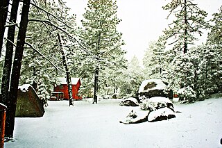
Chaparral is a shrubland plant community found primarily in California, in southern Oregon and in the northern portion of the Baja California Peninsula in Mexico. It is shaped by a Mediterranean climate and infrequent, high-intensity crown fires.

<span class="mw-page-title-main">Palearctic realm</span> Biogeographic realm covering most of Eurasia

The Palearctic or Palaearctic is the largest of the eight biogeographic realms of the Earth. It stretches across all of Eurasia north of the foothills of the Himalayas, and North Africa.

<span class="mw-page-title-main">California chaparral and woodlands</span> Ecoregion in the western United States and Mexico

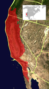
The California chaparral and woodlands is a terrestrial ecoregion of southwestern Oregon, northern, central, and southern California and northwestern Baja California (Mexico), located on the west coast of North America. It is an ecoregion of the Mediterranean forests, woodlands, and scrub biome, and part of the Nearctic realm.

<span class="mw-page-title-main">Ecology of California</span> Environments and natural history of California

The ecology of California can be understood by dividing the state into a number of ecoregions, which contain distinct ecological communities of plants and animals in a contiguous region. The ecoregions of California can be grouped into four major groups: desert ecoregions, Mediterranean ecoregions, forested mountains, and coastal forests.

<span class="mw-page-title-main">Ecology of the Sierra Nevada</span> Ecological features of the Sierra Nevadas

The ecology of the Sierra Nevada, located in the U.S. states of California and Nevada, is diverse and complex. The combination of climate, topography, moisture, and soils influences the distribution of ecological communities across an elevation gradient from 500 to 14,500 feet. Biotic zones range from scrub and chaparral communities at lower elevations, to subalpine forests and alpine meadows at the higher elevations. Particular ecoregions that follow elevation contours are often described as a series of belts that follow the length of the Sierra Nevada. There are many hiking trails, paved and unpaved roads, and vast public lands in the Sierra Nevada for exploring the many different biomes and ecosystems.

<span class="mw-page-title-main">California Central Valley grasslands</span> Temperate grasslands, savannas, and shrublands ecoregion in California, United States

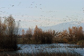
The California Central Valley grasslands is a temperate grasslands, savannas, and shrublands ecoregion in California's Central Valley. It a diverse ecoregion containing areas of desert grassland, prairie, savanna, riparian forest, marsh, several types of seasonal vernal pools, and large lakes such as now-dry Tulare Lake, Buena Vista Lake, and Kern Lake.

<span class="mw-page-title-main">Foothills of the San Gabriel Valley</span>

The foothills of the San Gabriel Valley are the foothills and hills in the San Gabriel Valley of eastern Los Angeles County, California. They include the foothills of the San Gabriel Mountains, and independent low mountain ranges of hills, in the east Greater Los Angeles region. The landforms are part of the Transverse Ranges System of Southern California and Baja California.

<span class="mw-page-title-main">Southwest Australia</span> Biogeographic region of Western Australia

Southwest Australia is a biogeographic region in Western Australia. It includes the Mediterranean-climate area of southwestern Australia, which is home to a diverse and distinctive flora and fauna.

<span class="mw-page-title-main">Garrigue</span> Shrubland plant community in the Mediterranean

Garrigue or garigue, also known as phrygana, is a type of low scrubland ecoregion and plant community in the Mediterranean forests, woodlands, and scrub biome.

<span class="mw-page-title-main">Sierra de Juárez</span> Mountain range in Baja California, Mexico

The Sierra de Juárez, also known as the Sierra Juarez, is a mountain range located in Tecate Municipality and northern Ensenada Municipality, within the northern Baja California state of northwestern Mexico.

<span class="mw-page-title-main">Sierra Juárez and San Pedro Mártir pine–oak forests</span> Temperate coniferous forests ecoregion in Baja California, Mexico

The Sierra Juárez and San Pedro Mártir pine–oak forests is a Nearctic temperate coniferous forests ecoregion that covers the higher elevations of the Sierra Juárez and Sierra San Pedro Mártir ranges of the Peninsular Ranges, of the northern Baja California Peninsula of Mexico. The pine–oak forests extend throughout the central portion of the Mexican state of Baja California and terminate near the border with the U.S. state of California.

<span class="mw-page-title-main">Golden Gate Biosphere Network</span>

The Golden Gate Biosphere Network is a voluntary coalition of federal, state, and local government agencies, nonprofit organizations, universities, and private partners within the Golden Gate Biosphere region. The Network aims to protect the region's biodiversity and conserve its natural resources, enhancing quality of life for local residents. The Network has been part of the UNESCO Man and Biosphere Programme since 1988 and is part of the US Biosphere Network and EuroMAB. It is recognized by UNESCO due to the significant biodiversity of the region, as well as the Network's efforts to demonstrate and promote a balanced relationship between humans and the biosphere.

<span class="mw-page-title-main">California Floristic Province</span> Region of uniform plant variety in the western United States and Mexico

The California Floristic Province (CFP) is a floristic province with a Mediterranean-type climate located on the Pacific Coast of North America with a distinctive flora similar to other regions with a winter rainfall and summer drought climate like the Mediterranean Basin. This biodiversity hotspot is known for being the home of the Sierran giant sequoia tree and its close relative the coast redwood. In 1996, the Province was designated as a biodiversity hotspot allowing it to join ranks among 33 other areas in the world with many endemic species. To be named a biodiversity hotspot, an area has to contain species and plant life that cannot be found anywhere else in the world. The California Floristic Province is home to over 3,000 species of vascular plants, 60% of which are endemic to the province.

<span class="mw-page-title-main">Bitter Creek National Wildlife Refuge</span> Wildlife refuge in Kern County, California

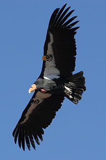
The Bitter Creek National Wildlife Refuge is located in the foothills of the southwestern San Joaquin Valley in Kern County, California. The refuge is one of four units of the Hopper Mountain National Wildlife Refuge Complex for California condors.

<span class="mw-page-title-main">California coastal sage and chaparral</span> Mediterranean forests, woodlands, and scrub ecoregion in Mexico and the United States

The California coastal sage and chaparral is a Mediterranean forests, woodlands, and scrub ecoregion, defined by the World Wildlife Fund, located in southwestern California and northwestern Baja California (Mexico). It is part of the larger California chaparral and woodlands ecoregion. The ecoregion corresponds to the USDA Southern California ecoregion section 261B, and to the EPA Southern California/Northern Baja Coast ecoregion 8.

<span class="mw-page-title-main">California montane chaparral and woodlands</span> Mediterranean forests, woodlands, and scrub ecoregion in California, United States

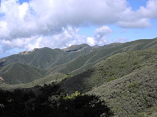
The California montane chaparral and woodlands is an ecoregion defined by the World Wildlife Fund, spanning 7,900 square miles (20,000 km2) of mountains in the Transverse Ranges, Peninsular Ranges, and Coast Ranges of southern and central California. The ecoregion is part of the larger California chaparral and woodlands ecoregion, and belongs to the Mediterranean forests, woodlands, and scrub biome.

<span class="mw-page-title-main">California interior chaparral and woodlands</span> Mediterranean forests, woodlands, and scrub ecoregion in California, United States

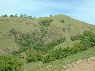
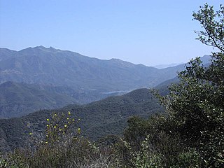
The California interior chaparral and woodlands ecoregion covers 24,900 square miles (64,000 km2) in an elliptical ring around the California Central Valley. It occurs on hills and mountains ranging from 300 feet (91 m) to 3,000 feet (910 m). It is part of the Mediterranean forests, woodlands, and scrub biome, with cool, wet winters and hot, dry summers. Temperatures within the coast can range from 53° to 65 °F and 32° to 60 °F within the mountains. Many plant and animal species in this ecoregion are adapted to periodic fire.

<span class="mw-page-title-main">Mediterranean forests, woodlands, and scrub</span> Habitat defined by the World Wide Fund for Nature

Mediterranean forests, woodlands and scrub is a biome defined by the World Wide Fund for Nature. The biome is generally characterized by dry summers and rainy winters, although in some areas rainfall may be uniform. Summers are typically hot in low-lying inland locations but can be cool near colder seas. Winters are typically mild to cool in low-lying locations but can be cold in inland and higher locations. All these ecoregions are highly distinctive, collectively harboring 10% of the Earth's plant species.

<span class="mw-page-title-main">Tundra of North America</span>

The Tundra of North America is a Level I ecoregion of North America designated by the Commission for Environmental Cooperation (CEC) in its North American Environmental Atlas.

References

  1. Commission for Environmental Cooperation (Lead Author);C Michael Hogan (Contributing Author);Mark McGinley (Topic Editor) "Mediterranean California ecoregion (CEC)". In: Encyclopedia of Earth. Eds. Cutler J. Cleveland (Washington, D.C.: Environmental Information Coalition, National Council for Science and the Environment). First published in the Encyclopedia of Earth March 2, 2010; Last revised Date June 2, 2011; Retrieved February 25, 2013 <http://www.eoearth.org/article/Mediterranean_California_ecoregion_(CEC)>
  2. Conrad, E. 1987. Common shrubs of chaparral and associated ecosystems of southern California. Pacific Southwest Forest and Range Experiment Station, Berkeley, CA.
  3. 1 2 Zedler, P.; Gautier, R.; McMaster, G. (1983). "Vegetation change in response to extreme events: the effect of a short interval between fires in California chaparral and coastal scrub". Ecology. 64 (4): 809–818. doi:10.2307/1937204. JSTOR   1937204.
  4. Fleming, G., J. Diffendorfer, P. Zedler. 2009. The relative importance of distribution and exotic-plant abundance in California coastal sage scrub" Ecological Applications, Vol 19, No. 9 (2210-2227).