Meehan, Mississippi

Last updated

Meehan, Mississippi
Road sign for Meehan, Mississippi.jpg
Sign for Meehan
USA Mississippi location map.svg
Red pog.svg
Meehan
Usa edcp location map.svg
Red pog.svg
Meehan
Coordinates: 32°19′42″N88°51′59″W / 32.32833°N 88.86639°W / 32.32833; -88.86639
Country United States
State Mississippi
County Lauderdale
Elevation
338 ft (103 m)
Time zone UTC-6 (Central (CST))
  Summer (DST) UTC-5 (CDT)
ZIP code
39307
Area code(s) 601 & 769
GNIS feature ID673459 [1]

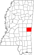
Meehan, also known as Meehan Junction, is an unincorporated community in Lauderdale County, Mississippi, United States. [1] Its ZIP code is 39307. [2] The community is also known as Meehan Junction, as it was located at the crossing of the former Alabama & Vicksburg Railroad and the Tallahatta Railway. [3]

Contents

History

The Meehan-Rounds Lumber Company once operated a sawmill in Meehan. [4] In 1919, J.F. Craig of Indianola, Mississippi purchased 26,000 acres, including the site of Meehan. Much of the land was cut over due to previous logging activity, but Craig planned on using the community to house his tenant farmers. Craig purchased the land with the intention of raising cattle on it and using the remaining small timber as railroad ties. [5]

A post office operated under the name Siding from 1889 to 1902, Meehan Junction from 1902 to 1950, and Meehan from 1950 to 1958. [6]

Notes

  1. 1 2 "Meehan, Mississippi". Geographic Names Information System . United States Geological Survey, United States Department of the Interior.
  2. United States Postal Service (2021). "USPS - Look Up a ZIP Code" . Retrieved January 26, 2021.
  3. Rowland, Dunbar (1907). Mississippi: Comprising Sketches of Counties, Towns, Events, Institutions, and Persons, Arranged in Cyclopedic Form (PDF). Vol. 2. Southern Historical Publishing Association. p. 216.
  4. Howe, Tony. "Tallahatta Railroad". Mississippi Rails. Retrieved December 11, 2022.
  5. Collins, C. E. (August 7, 1919). "A Western Farmer's Experience in Mississippi". Manufacturers Record. Vol. 76, no. 6. Baltimore, MD. p. 101.
  6. Howe, Tony. "Meehan, Mississippi". Mississippi Rails. Retrieved December 10, 2022.


Related Research Articles

<span class="mw-page-title-main">Holcomb, Mississippi</span> Census-designated place in Mississippi, United States

Holcomb is an unincorporated community and census-designated place (CDP) in Grenada County, Mississippi, United States. It is part of the Grenada Micropolitan Statistical Area. As of the 2010 census the community had a population of 600.

Cedarbluff is an unincorporated community in Clay County, Mississippi, United States. It is located in south central Clay County along Mississippi Highway 50.

Stringer is an unincorporated community in southwestern Jasper County, Mississippi, United States. It lies at the intersections of State Highways 15 and County Road 10, just north of Mississippi State Highway 533, between Bay Springs and Laurel. The population was 1,867 at the 2010 census.

<span class="mw-page-title-main">Rena Lara, Mississippi</span> Census-designated place in Mississippi, United States

Rena Lara is a census-designated place and unincorporated community located along Mississippi Highway 1 in southwestern Coahoma County, Mississippi, United States. Rena Lara is located on the former Riverside Division of the Yazoo and Mississippi Valley Railroad. Rena Lara was once home to two general stores, two grocery stores, and the Richardson and May Land & Planting Company.

Lamar is a census-designated place and unincorporated community in Benton County, Mississippi, United States. It is located along Mississippi Highway 7 in western Benton County. Lamar has a post office with the ZIP code 38642. The nearly abandoned Mississippi Central Railroad runs through Lamar, and is only used rarely for freight trafficking. Lamar shares its ZIP code with the nearby community of Slayden.

Michigan City, formerly known as Davis Mills, is an unincorporated community in Benton County, Mississippi, United States. Although unincorporated, Michigan City has a post office, with the ZIP code of 38647.

Grace is a census-designated place and unincorporated community in Issaquena County, Mississippi, United States. It is located several miles northeast of Mayersville.

<span class="mw-page-title-main">Swiftown, Mississippi</span> Unincorporated community in Mississippi, United States

Swiftown, is an unincorporated community located in Leflore County, Mississippi, United States. Swiftown is approximately 7 miles (11 km) south of Morgan City, 10 miles (16 km) north of Belzoni and 14 miles (23 km) southeast of Moorhead along Mississippi Highway 7. It is part of the Greenwood, Mississippi micropolitan area. Swiftown's ZIP code is 38959.

Sontag is an unincorporated community in northwest Lawrence County, Mississippi. It is the nearest community to Johnson-White House, a house listed on the U.S. National Register of Historic Places that was designed by architect Andrew Johnson. The community is located on the former Illinois Central Railroad. In 1900, the population was 25. The zip code is: 39665.

Carson is an unincorporated community in Jefferson Davis County, Mississippi, United States. Carson is located on Mississippi Highway 42, 6 miles (9.7 km) southeast of Prentiss. Carson has a post office with ZIP code 39427.

Neely is an unincorporated community in Greene County, Mississippi, United States. Its ZIP code is 39461.

Ruth is an unincorporated community in Lincoln County, Mississippi, United States. Its ZIP code is 39662.

Oak Vale is an unincorporated community in Jefferson Davis and Lawrence counties, Mississippi, United States. Its ZIP code is 39656. Oak Vale is located on the former Illinois Central Railroad and was once home to a bank and general store. A post office operated under the name Oakvale from 1856 to 1869 and began operating under the name Oak Vale in 1873.

<span class="mw-page-title-main">Vossburg, Mississippi</span> Unincorporated community in Mississippi, United States

Vossburg is an unincorporated community in Jasper County, Mississippi, United States. Its ZIP code is 39366.

Pattison, also known as Martin, is a census-designated place and unincorporated community in Claiborne County, Mississippi, United States. Its ZIP code is 39144.

Arm is an unincorporated community in Lawrence County, Mississippi, United States. Arm is located on Mississippi Highway 43 6.4 miles (10.3 km) east-southeast of Monticello, and 2.3 miles (3.7 km) south of the junction with Mississippi Highway 43A.

Gallman is an unincorporated community in Copiah County, Mississippi, United States. Gallman is located along Interstate 55 and U.S. Route 51 4.25 miles (6.84 km) south-southwest of Crystal Springs. Gallman has a post office with ZIP code 39077, which opened on November 8, 1872.

<span class="mw-page-title-main">Wingate, Mississippi</span> Unincorporated community in Mississippi, United States

Wingate is an unincorporated community located in Perry County, Mississippi.

Piave is an unincorporated community in Greene County, Mississippi.

<span class="mw-page-title-main">Point, Mississippi</span> Unincorporated community in Mississippi, United States

Point is an unincorporated community in Lauderdale County, Mississippi, United States. Its ZIP code is 39323.