
Palakkad District is one of the 14 districts in the Indian state of Kerala. It was carved out from the southeastern region of the former Malabar District on 1 January 1957. It is located at the centre of Kerala. It is the largest district in the state since 2006. The city of Palakkad is the district headquarters. Palakkad is bordered on the northwest by the Malappuram district, on the southwest by the Thrissur district, on the northeast by Nilgiris district, and on the east by Coimbatore district of Tamil Nadu. The district is nicknamed "The granary of Kerala". Palakkad is the gateway to Kerala due to the presence of the Palakkad Gap, in the Western Ghats. The 2,383 m high Anginda peak, which is situated in the border of Palakkad district, Nilgiris district, and Malappuram district, in Silent Valley National Park, is the highest point of elevation in Palakkad district. Palakkad city is located just 50 km away from Coimbatore, a major city in Tamil Nadu state.

Shornur is a town and a municipality located in the Palakkad district, in the Indian state of Kerala, located on the banks of the Bharathapuzha River. The town covers an area of 32.28 km2.
Vadakkencherry is a town and gram panchayat in the Palakkad district, state of Kerala, India. It is located about 35 km from Palakkad along National Highway 544.

Pattambi is a town taluk, and municipality in Palakkad district of the state of Kerala, India. It is also the administrative headquarters of the Pattambi Taluk. Pattambi is located along the banks of Bharathapuzha river.A Mini Civil Station is also functioning here to provide the government related services.

Palakkad, also known as Palghat, is a city and municipality in the Indian state of Kerala. It is the administrative headquarters of the Palakkad District.Palakkad is one of the oldest cities in Kerala and is famous for the ancient Palakkad Fort which is situated in the heart of the city.The city is situated about 347 kilometres (216 mi) northeast of the state capital Trivandrum.

Palarivattom (MRC) is a region in the city of Kochi in the state of Kerala, India. It is part of the District of Ernakulam. The region makes a four-directional intersection at its highway signal point on the Kochi Bypass, which leads to 1) the Vyttila Junction in the South, 2) Kakkanad in its western direction, which is the IT hub of Kochi city, 3) the main junction of Edapally in its north end, which then diverges into the Northern and North-western regions of Kerala such as Kodangallur, Guruvayur, Thrissur, Calicut, etc., and 4) eastward towards the central town area of Kochi. The junction is sometimes also referred to as pipeline junction. Santhigiri Ashram Ernakulam Branch is in palarivattom.

Koottanad is a town in Nagalassery Panchayath of Pattambi taluk of Palakkad district, in the state of Kerala. It is situated at the border of Thrissur, Palakkad and Malapuram districts. It is located 32 km from the Thrissur and 65 km from Palakkad, on the road between Guruvayoor and Palakkad. It is connected by road to other parts of Kerala and the nearest Railway station is Pattambi 9 km away. Bharathapuzha Nila Riverflows through Thrithala, 5 km away. The Pakkanar Memorial, a tribute to the Pariah saint of Parayi petta panthirukulam can be found at Thrithala. The Kattil Madam Temple, a small granite Buddhist monument on the Pattambi-Guruvayoor road, is of great archaeological importance. It is believed to date back to the 9th/10th century AD. The debris of a Fort can be seen behind Juma Mazjid, Koottanad between Koottanad and Chalissery Road.
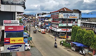
Pathirippala is a town in Palakkad district, Kerala, India, between Ottappalam and Palakkad on the Palakkad–Ponnani state highway SH 23.

Purathur is a beautiful sandy coastal village and a Grama Panchayat in Tirur Taluk, Malappuram district in the state of Kerala, India. Bharathappuzha river and Tirur River merges together in Purathur and join with the Arabian Sea at Padinjarekara Azhimukham, which is also the southernmost tip of Purathur Gram panchayat. Opposite to Padinjarekara Azhimukham is Ponnani port. The village is located at the southernmost tip of Tirur Taluk and is bordered by historically important Ponnani port in Ponnani Municipality of Ponnani taluk to south.
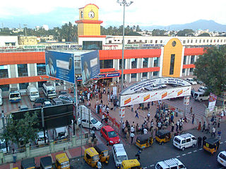
Coimbatore Junction railway station, also known as Kovai Junction railway station, is the primary railway station serving Coimbatore city.

Shoranur Junction is the railway station located at Shoranur, Palakkad District, Kerala. It comes under the Palakkad Railway Division of the Southern Railway. It is the largest railway station in the state of Kerala in terms of area. It is an important junction because it is the point at which the line from Chennai via Jolarpettai, Erode and Palakkad meets the coastal line from Mangalore to Kanyakumari. Further, Shoranur junction is the node from which a separate Branch line goes to the town of Nilambur, about 66 km to the north. The Nilambur–Shoranur line, which connects two tiny hill-towns, is one of the most picturesque in India.

Kaloor is a downtown region in the city of Kochi, in the state of Kerala, India. It is two kilometres (1.2 mi) from the Ernakulam North Railway Station. Kaloor Junction is also the name of a major intersection in this part of the city, intersecting the two major arteries of downtown Kochi, namely Banerji Road and the Kaloor-Kadavanthra Road. The nearest major intersections are Palarivattom to the east and Lissie Junction to the west.
Mezhathur is an Indian village in the state of Kerala situated at Pattambi taluk of Palakkad district at the border of Thrissur, Malappuram and Palakkad districts. It is a historical and cultural village in Kerala. It is known for traditional Ayurveda physicians like Chatharu Nair and Vaidyamadom Valiya Narayanan Namboodiri. It is also the native place of renowned writer and social reformer V. T. Bhattathiripad. It is also the Birth place of Renowned Sanskrit Scholar and Critic M.P. Sankunni Nair.

Palakkad Junction is one of the largest railway station in Kerala state, India situated in the city of Palakkad and the second largest railway station in the district. Palakkad Junction is the cleanest railway station in the state of Kerala as per the survey conducted by Indian Railway Catering & Tourism Corporation. It also boasts one of the longest railway platforms in Kerala. It is situated at about 3 km from Sree Guruvayurappan Temple, 5 km from Puthur, where the famous Puthur-Vela is celebrated annually, 5.6 km from Palakkad Fort, 7.2 km from Dhoni Waterfalls, 43 km from Siruvani Dam and 45 km from Silent Valley National Park. It serves as the major railway hub for the city of Palakkad in Kerala while the secondary hub being the smaller Palakkad Town railway station which is situated within the city.
P. Sreeramakrishnan, is an Indian politician born on 14 November 1967 in Perinthalmanna. He became a member of the Thirteenth Kerala Legislative Assembly on 1 June 2011. He also served as the Speaker of Kerala Legislative Assembly from 2016 to 2021.
Kanjikode or Kanchikode is an industrial town located 11 km (6.8 mi) east of Palakkad. Kanjikode is a growing suburb of Palakkad city. The town is in the gram panchayat of Pudusseri within the Palakkad district of the Kerala state. It is the second largest industrial area in Kerala after Kochi .First and the only Indian Institute of Technology in Kerala, IIT Palakkad was established in Kanjikode.
Mundur is a town and gram panchayat in the Palakkad district, state of Kerala, India.Mundur is an important junction which connects National Highway 966 and State Highway 53. It is located about 11 km from Palakkad city and is one of the growing suburbs.

Chalappuram is a suburb of Kozhikode city in India.

South Malabar refers to a geographical area of the southwestern coast of India covering some parts of the present-day Kerala. South Malabar covers the regions included in present-day Kozhikode Taluk of Kozhikode district, whole area of Malappuram district, Chavakkad Taluk of Thrissur district, and Palakkad district excluding parts of Chittur Taluk. The Fort Kochi region of Kochi city also historically belongs to South Malabar. The term South Malabar refers to the region of the erstwhile Malabar District which lies south to the river Korapuzha and bears high cultural similarity with both the Cochin as well as the North Malabar region.
Sulthanpet is a major commercial area in Palakkad city, Kerala, India.Sulthanpet junction is a junction of four important roads of the city namely Gandhi Bazaar Road, Head Post Office/Victoria College Road, Court Road and Coimbatore Road.This area mainly consists of malls, commercial buildings, offices, branded outlets, banks and wholesale shops. Sulthanpet is ward 15 of Palakkad Municipality.Stadium Bus Stand, the largest private bus stand in the city is located in near Sulthanpet. Government Victoria College is situated about 2 km from Sulthanpet junction.

