
Dorset is a ceremonial county in South West England. It is bordered by Somerset to the north-west, Wiltshire to the north and the north-east, Hampshire to the east, the Isle of Wight across the Solent to the south-east, the English Channel to the south, and Devon to the west. The largest settlement is Bournemouth, and the county town is Dorchester.

The Isle of Portland is a tied island, 6 kilometres (4 mi) long by 2.7 kilometres (1.7 mi) wide, in the English Channel. The southern tip, Portland Bill, lies 8 kilometres (5 mi) south of the resort of Weymouth, forming the southernmost point of the county of Dorset, England. A barrier beach called Chesil Beach joins Portland with mainland England. The A354 road passes down the Portland end of the beach and then over the Fleet Lagoon by bridge to the mainland. The population of Portland is 13,417.
Rowley Regis is a town and former municipal borough in Sandwell in the county of the West Midlands, England. It forms part of the area immediately west of Birmingham known as the Black Country and encompasses the three Sandwell council wards of Blackheath, Cradley Heath and Old Hill, and Rowley. At the 2011 census, the combined population of these wards was 50,257.

Weymouth and Portland was a local government district with borough status in Dorset, England from 1974 to 2019. It consisted of the resort of Weymouth and the Isle of Portland, and includes the areas of Wyke Regis, Preston, Melcombe Regis, Upwey, Broadwey, Southill, Nottington, Westham, Radipole, Chiswell, Castletown, Fortuneswell, Weston, Southwell and Easton; the latter six being on the Isle of Portland.

Sandsfoot Castle, also known historically as Weymouth Castle, is an artillery fort constructed by Henry VIII near Weymouth, Dorset. It formed part of the King's Device programme to protect against invasion from France and the Holy Roman Empire, and defended the Weymouth Bay anchorage. The stone castle had an octagonal gun platform, linked to a residential blockhouse, and was completed by 1542 at a cost of £3,887. Earthwork defences were built around the landward side of the castle, probably in 1623. Sandsfoot saw service during the English Civil War, when it was held by Parliament and Royalists in turn during the conflict. It survived the interregnum but, following Charles II's restoration to the throne, the fortress was withdrawn from military use in 1665.

Preston is a coastal village and suburb of Weymouth in south Dorset, England. It is approximately 3 kilometres (2 mi) north-east of Weymouth town centre and 2 kilometres (1 mi) west of the village of Osmington.

Wyke Regis is a village in the civil parish of Weymouth, in south Dorset, England. The village is part of the south western suburbs of Weymouth, on the northern shore of Portland Harbour and the south-eastern end of Chesil Beach. Wyke is 15 kilometres (9 mi) south of the county town, Dorchester. The village has a population of around 5,500.

South Dorset is a constituency represented in the House of Commons of the UK Parliament since 2024 by Lloyd Hatton, of the Labour Party. The constituency was created as a consequence of the Redistribution of Seats Act 1885, although the area covered has changed since then.

Upwey is a suburb of Weymouth in south Dorset, England. The suburb is situated on the B3159 road in the Wey valley. The area was formerly a village until it was absorbed into the Weymouth built-up area. It is located four miles north of the town centre in the outer suburbs. In the Census 2001 the combined population of Upwey and neighbouring Broadwey was 4,349.

Weymouth Beach is a gently curving arc of sand in Weymouth Bay, beside the town of Weymouth in Dorset, England. Immediately adjacent to the beach is The Esplanade.

Radipole is a suburb of Weymouth in Dorset, England.

Holdenhurst is a village in the civil parish of Throop and Holdenhurst, in the Bournemouth, Christchurch and Poole district, in Dorset, England, situated in the green belt land of the north-east suburbs of Bournemouth. The village comprises fewer than 30 dwellings, two farms and the parish church. There are no shops and few local facilities in the village.
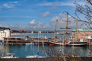
Weymouth is a seaside town and civil parish in the Dorset district, in the ceremonial county of Dorset, England. Situated on a sheltered bay at the mouth of the River Wey, 7 miles (11 km) south of the county town of Dorchester, Weymouth had a population of 53,416 in 2021. It is the third-largest settlement in Dorset after Bournemouth and Poole.
Cotton Fort was a small fortification in Melcombe, now part of the town of Weymouth, Dorset. No trace of the fort exists today.
The Great Storm of 1824 was a hurricane force wind and storm surge that affected the south coast of England from 22 November 1824. Nearly 100 people were believed to be killed.

Weymouth Town Bridge is a lifting bascule bridge in Weymouth, Dorset, England, connecting the formerly separate boroughs of Weymouth and Melcombe Regis. The bridge can be lifted to allow boats access to the inner backwater of Weymouth Harbour, known as Weymouth Marina. The bridge, opened in 1930, is the sixth to have been built across the harbour since 1597 and has been Grade II Listed since 1997. Today, the hydraulically-operated bridge is raised every two hours, 363 days of the year.

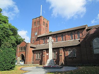
St Mary's Church is a Church of England parish church in Weymouth, Dorset, England. Built of Portland stone in 1815–1817, the church has been described as having an "austere design in Palladian mode". It has been a Grade I listed building since 1953.

Weymouth Guildhall is a former guildhall at Weymouth, Dorset, England. The building, which was constructed in the 1830s, is a Grade II* listed building.

Christ Church was a Church of England church in Weymouth, Dorset, England. It was built between 1873 and 1874 as a chapel of ease to the parish church of St Mary's. It closed as a place of worship in 1939 and was demolished in 1957. The site is now occupied by the residential Garnet Court.

