
The City and Borough of Juneau, more commonly known simply as Juneau, is the capital city of the state of Alaska. Located in the Gastineau Channel and the Alaskan panhandle, it is a unified municipality and the second-largest city in the United States by area. Juneau was named the capital of Alaska in 1906, when the government of what was then the District of Alaska was moved from Sitka as dictated by the U.S. Congress in 1900. The municipality unified on July 1, 1970, when the city of Juneau merged with the city of Douglas and the surrounding Greater Juneau Borough to form the current municipality, which is larger by area than both Rhode Island and Delaware.

Douglas Island is a tidal island in the U.S. state of Alaska. It is part of the city and borough of Juneau, just west of downtown Juneau and east of Admiralty Island. It is separated from mainland Juneau by the Gastineau Channel, and contains the communities of Douglas and West Juneau.

Mendenhall Glacier is a glacier about 13.6 miles (21.9 km) long located in Mendenhall Valley, about 12 miles (19 km) from downtown Juneau in the southeast area of the U.S. state of Alaska. The glacier and surrounding landscape is protected as part of the 5,815 acres (2,353 ha) Mendenhall Glacier Recreation Area, a federally designated unit of the Tongass National Forest.
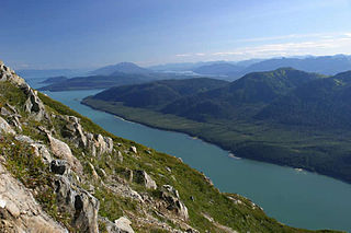
Gastineau Channel is a channel between the mainland of the U.S. state of Alaska and Douglas Island in the Alexander Archipelago of southeastern Alaska. It separates Juneau on the mainland side from Douglas, on Douglas Island. The first European to sight the channel was Joseph Whidbey whilst serving on the Royal Navy's Vancouver Expedition early in August 1794, first from the south and later from the west. It was probably named for John Gastineau, an English civil engineer and surveyor.
The Mendenhall River is an Alaskan river north of Juneau in the Mendenhall Valley. The river begins at the Mendenhall Lake, at the base of the Mendenhall Glacier.

The Juneau Icefield is an ice field located just north of Juneau, Alaska, continuing north through the border with British Columbia, extending through an area of 3,900 square kilometres (1,500 sq mi) in the Coast Range ranging 140 km (87 mi) north to south and 75 km (47 mi) east to west. The icefield is the source of many glaciers including the Mendenhall Glacier and the Taku Glacier. The icefield is home to over 40 large valley glaciers and 100 smaller ones. The Icefield serves as a tourist attraction with many travellers flown in by helicopter for quick walks on the 240-to-1,400-metre deep ice and the massive, awe-inspiring moist crevasses. The icefield, like many of its glaciers, reached its maximum glaciation point around 1700 and has been in retreat since. In fact, of the icefield's 19 notable glaciers, the Taku Glacier is the only one presently advancing. Much of the icefield is contained within the Tongass National Forest. Since 1948, the Juneau Icefield Research Program has monitored glaciers of the Juneau Icefield. On the west side of the icefield, from 1946-2009, the terminus of the Mendenhall Glacier has retreated over 700 metres (0.43 mi).
Out the road is a colloquial term for a region of the City and Borough of Juneau, capital of the U.S. state of Alaska, extending from Auke Bay north to a point roughly 45 miles (72 km) from downtown Juneau to where "The Road" dead ends at Echo Cove, a natural harbor with a boat ramp, parking lot, and several camping areas. Juneau is accessible only by boat or plane. Out the road is by far the largest percentage of land area of Juneau, but very sparsely populated; in spring 1998, the Juneau Economic Development Council put its population at 1,348.
The Juneau School District is a school district in Juneau, Alaska. Its office is located in Downtown Juneau.
Auke Bay is a neighborhood located in the city and borough of Juneau, Alaska, that contains Auke Bay Harbor, Auke Lake, the University of Alaska Southeast, an elementary school, a church, a post office, a bar, a coffee shop, a waffle house, a thrift shop, a Thai restaurant, and one convenience store. The view of the Mendenhall Glacier behind Auke Bay and Mount McGinnis towering over Auke Lake are some of the most popular photo opportunities in Juneau. The ferry terminal of the Alaska Marine Highway system is also located further out the road in Auke Bay at about 14 miles. The flamingo house on Auke Lake is a local attraction, known for its topical or weather-related formations of pink lawn flamingos. Whale watchings targeting curious humpbacks are available. Humpbacks in these areas are known to demonstrate special feeding methods, so-called "bubble-net feeding", and come very close to shores.
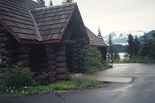
Chapel by the Lake is a Presbyterian church in Auke Bay, Alaska. It was designed by Juneau-based architects Harold Foss and Linn A. Forrest. The construction lasted from 1954 to 1958.

The Capital Transit System is the public transportation agency that serves the City and Borough of Juneau, Alaska. Owned by the municipality, it operates sixteen bus routes, three of which run 6am to 11pm, seven days a week, with the remaining thirteen running as limited weekday express services. Although CTS, like most US bus systems, operates fixed routes with fixed stations, some stops are flag stop only and some routes offer complete flag stop service along the route.

The Co-Cathedral of the Nativity of the Blessed Virgin Mary was until 2020 the mother church of the Roman Catholic Diocese of Juneau and is currently a cathedral of the Roman Catholic Archdiocese of Anchorage-Juneau. The cathedral is located at 416 Fifth Street in Juneau, Alaska. The cathedral may be the smallest in North America.

The 2012 United States House of Representatives election in Alaska was held on Tuesday, November 6, 2012, to elect the U.S. representative from Alaska's at-large congressional district, who will represent the state of Alaska in the 113th United States Congress. The election coincided with the elections of other federal and state offices, including a quadrennial presidential election. As is the case every twelve years in Alaska, this will be the only statewide election contest held amongst this year's elections. A primary election was held on August 28, 2012.
Fritz Cove is a bay on the northwestern coast of Douglas Island in the City and Borough of Juneau, Alaska, United States. Lying in Stephens Passage, it is 8 miles (13 km) northwest of the city of Juneau.
Nugget Creek is fed by the Nugget Glacier, a tributary glacier on the mountainside east of Auke Bay in the borough of Juneau, Alaska, US. The creek feeds Nugget Falls. The valley of Nugget Creek joins that of Mendenhall River about 1.5 miles (2.4 km) above the foot of the glacier. Its basin, about 3 miles (4.8 km) in length, trends east and west, and there are several tributary gulches which head against the Lemon Creek divide. The rocks of the valley belong to the group of schists which lies next to the main diorite, except at the headwaters, where the edge of the intrusive rock appears.

Berners Bay is a waterway in the U.S. state of Alaska, approximately 40 miles (64 km) north of Juneau. It is a large and deep indentation, about 3.5 miles (5.6 km) wide at the entrance, which is formed by Point Bridget and Point St. Marys. It runs in a north-northwest direction for 6 miles (9.7 km) from Point Bridget, with a width of 3 miles (4.8 km) opposite Point St. Marys. The bay is surrounded by Tongass National Forest.

The Juneau gold belt is located in the southeastern portion of the U.S. state of Alaska. This belt is approximately 100 miles (160 km) in length, north/northwest-trending, and extends from Berners Bay southeastward to Windham Bay, 60 miles (97 km) southeast of Juneau, and includes Douglas Island. The belt contains over 200 gold-quartz-vein deposits with production nearing 7,000,000 ounces (200,000,000 g) of gold. More than three-quarters of Alaska's lode gold was mined from the Juneau gold belt.
Justin V. Parish is an American politician who served for one term in the Alaska House of Representatives. His family includes Tlingit people. In 2017, “Representative Justin Parish, a first-time legislator, introduced himself in Tlingit and acknowledged his own Native heritage. His paternal grandmother is a member of the Dog Salmon clan.”

Jesse Kiehl is a Democratic member of the Alaska Legislature representing the State Senate's Q district and a former member of the Assembly of the City and Borough of Juneau, Alaska.
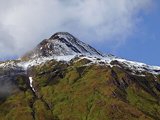
McGinnis Mountain, also known as Mount McGinnis, is a 4,232-foot (1,290 m) mountain summit located in the Boundary Ranges, in the U.S. state of Alaska. The peak is situated near the toe of the Mendenhall Glacier, within Tongass National Forest, 11 mi (18 km) north-northwest of Juneau, Alaska, and 6 mi (10 km) north of Juneau International Airport. Although modest in elevation, relief is significant since the mountain rises up from sea level at Auke Bay in less than five miles. McGinnis Mountain is often seen and photographed with Stroller White Mountain, a 5,118-foot (1,560 m) summit 1.6 mi (3 km) to the north because they are together in the background behind Mendenhall Lake, a popular tourist and recreation area.

