Rock Creek Park is a large urban park that bisects the Northwest quadrant of Washington, D.C. The park was created by an Act of Congress in 1890, and today is administered by the National Park Service. In addition to the park proper, the Rock Creek administrative unit of the National Park Service administers various other federally owned properties in the District of Columbia located to the north and west of the National Mall, including Meridian Hill Park on 16th Street, N.W., the Old Stone House in Georgetown, and certain of the Fort Circle Parks, a series of batteries and forts encircling the District of Columbia for its defense during the U.S. Civil War.

Meridian is the sixth largest city in the state of Mississippi, United States. It is the county seat of Lauderdale County and the principal city of the Meridian, Mississippi Micropolitan Statistical Area. Along major highways, the city is 93 mi (150 km) east of Jackson, Mississippi; 154 mi (248 km) southwest of Birmingham, Alabama; 202 mi (325 km) northeast of New Orleans, Louisiana; and 231 mi (372 km) southeast of Memphis, Tennessee.

Meridian Hill Park is a structured urban park located in the Washington, D.C. neighborhood of Columbia Heights; it also abuts the nearby neighborhood of Adams Morgan. The park was designed and built between 1912 and 1940. This 12 acre formally landscaped site is officially part of the National Capital Parks Unit of the National Park System, and is administered by the superintendent of nearby Rock Creek Park. Meridian Hill Park is bordered by 15th, 16th, W, and Euclid Streets NW, and sits on a prominent hill 1.5 miles (2.42 km) directly north of the White House. The park has also been unofficially known as "Malcolm X Park" by some city residents.

Meridian Playground is in the Wallingford neighborhood of Seattle, Washington, United States.

Meridian Highway was a United States auto trail in the early twentieth century. It roughly followed the path of present-day U.S. Route 81 from Pembina, North Dakota to Fort Worth, Texas, and Interstate 35 from Fort Worth to Laredo, Texas.
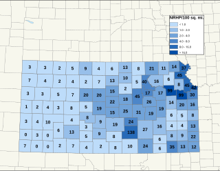
There are over 1,400 buildings, sites, districts, and objects in Kansas listed on the National Register of Historic Places in Kansas. NRHP listings appear in 101 of the state's 105 counties.

Historic Meridian Park Neighborhood is situated north of downtown Indianapolis, and located within the larger Mapleton Fall Creek Neighborhood. While the neighborhood is fairly small, it was listed on the National Register of Historic Places in 2009.

The Meridian Highway Bridge is a bridge that formerly carried U.S. Route 81 across the Missouri River between Nebraska and South Dakota. The Meridian Highway Bridge connects Yankton, South Dakota with rural Cedar County, Nebraska. The Meridian Bridge is a double deck bridge, with the top level having carried traffic into South Dakota from Nebraska, and the lower level having carried traffic into Nebraska from South Dakota.
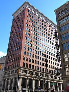
The Barnes and Thornburg Building is a high rise in Indianapolis, Indiana originally known as the Merchants National Bank Building. In 1905, the Merchants National Bank and Trust Company engaged the architectural firm of D. H. Burnham & Company of Chicago to design a new bank headquarters on the southeastern corner of the Washington and Meridian streets, the most important intersection in Indianapolis. Initial occupancy of the lower floors took place in 1908, while the upper floors were not completed until 1912.
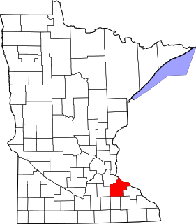
This is a list of the National Register of Historic Places listings in Goodhue County, Minnesota. It is intended to be a complete list of the properties and districts on the National Register of Historic Places in Goodhue County, Minnesota, United States. The locations of National Register properties and districts for which the latitude and longitude coordinates are included below, may be seen in an online map.

This is a list of the National Register of Historic Places listings in Fillmore County, Minnesota. It is intended to be a complete list of the properties and districts on the National Register of Historic Places in Fillmore County, Minnesota, United States. The locations of National Register properties and districts for which the latitude and longitude coordinates are included below, may be seen in an online map.

There are nine historic districts in Meridian, Mississippi. Each of these districts is listed on the National Register of Historic Places. One district, Meridian Downtown Historic District, is a combination of two older districts, Meridian Urban Center Historic District and Union Station Historic District. Many architectural styles are present in the districts, most from the late 19th century and early 20th century, including Queen Anne, Colonial Revival, Italianate, Art Deco, Late Victorian, and Bungalow.

The Morrison Block, also known as M. O'Connor Grocery Wholesalers and Peoples Outfitting Building, is a historic commercial building located on South Meridian Street in Indianapolis, Indiana, United States. It was built about 1870, and is a four-story, Italianate style timber frame and masonry building. It features round arched windows and a projecting cornice. The building has been restored.

Mount Meridian is an unincorporated community in Augusta County, Virginia, United States. Mount Meridian is located on the Middle River 1.9 miles (3.1 km) west of Grottoes. The Mt. Meridian Schoolhouse, which is listed on the National Register of Historic Places, is located near Mount Meridian.
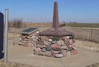
Site No. JF00-072 is a survey monument located at the quadripoint of Republic and Washington counties in Kansas and Jefferson and Thayer counties in Nebraska. The monument marks the intersection of the sixth principal meridian and its baseline, the 40th parallel north; it serves as the initial point of all land surveys in Kansas and Nebraska, as well as most of Wyoming and Colorado, and part of South Dakota. The original sandstone monument was 6 feet (1.8 m) tall. U.S. Deputy Surveyor Charles A. Manners set the monument in 1856. The monument was later buried under a county roadbed; it was unearthed and reburied twice before being dug up for good in 1986, though its middle section is now missing.

The First National Bank is a historic building located at 101 S. Main St. in Erick, Oklahoma. The two-story frame building was built in 1907. The building was primarily used as the city's bank; however, it also housed a barbershop in the rear and at one point had a second barbershop in the basement. The second floor of the building held various professional offices, including the courts of local justices of the peace. The bank operated in the building until 1968, during which time it served as Erick's commercial center.

William N. Thompson House, also known as Old Governor's Mansion, is a historic home located at Indianapolis, Marion County, Indiana. It was built in 1920, and is Georgian Revival style buff-colored brick mansion. It consists of a two-story, five-bay, central section flanked by one-story wings. It has a slate hipped roof and features a full width front porch and an elliptical portico at the main entry. The house served as the Governor's Mansion from 1945 to 1970.

North Meridian Street Historic District is a national historic district located at Indianapolis, Indiana. It encompasses 169 contributing buildings in a high style residential section of Indianapolis. The district developed between about 1900 and 1936, and includes representative examples of Tudor Revival, Colonial Revival, and Classical Revival style architecture. Located in the district is the separately listed William N. Thompson House. Other notable contributing resources include the Evan-Blankenbaker House (1901), Sears-Townsend House (1930), MacGill-Wemmer House, Hugh Love House (1930), Hare-Tarkington House (1911), Shea House (1922), and Brant-Weinhardt House (1932).

Shortridge–Meridian Street Apartments Historic District is a national historic district located at Indianapolis, Indiana. The district encompasses 136 contributing buildings in a predominantly residential section of Indianapolis. It was developed between about 1900 and 1951, and includes representative examples of Colonial Revival, Classical Revival, Late Gothic Revival, Mission Revival, Renaissance Revival, Bungalow / American Craftsman, and Art Deco style architecture. Located in the district is the separately listed Shortridge High School. Other notable buildings include the Vernon Court Apartments (1928), Fronenac Apartments (1951), Biltmore Apartments (1927), Meridian Apartments (1929), New Yorker Apartments (1917), Howland Manor (1929), Powell-Evans House (1911), Harms House (1906), Dorchester Apartments (1921), and Martin Manor Apartments (1916).

The Meridian Exchange Bank in Meridian, Idaho, was designed by the Boise architectural firm of Tourtellotte & Co. and constructed in 1906. Charles Hummel may have been the supervising architect. The 2-story, Renaissance Revival building was constructed of brick and sandstone by contractors Allen & Barber, and it featured a corner entry at Idaho Avenue and Second Street. The ground floor entry and a Second Street entry to the second floor both were framed by shallow brick pilasters supporting simple stone capitals. Four corbelled brick chimneys extended above the second floor parapet. The Meridian Exchange Bank and a barbershop occupied the ground floor, and the Independent Telephone Exchange rented the second floor. The building was added to the National Register of Historic Places (NRHP) in 1982.