
Yarra Junction is a town in Victoria, Australia, 55 km (34 mi) east from Melbourne's central business district, located within the Shire of Yarra Ranges local government area. Yarra Junction recorded a population of 2,875 at the 2021 census.
Rail transport in Australia is a component of the Australian transport system. It is to a large extent state-based, as each state largely has its own operations, with the interstate network being developed ever since Australia's federation in 1901. As of 2022, the Australian rail network consists of a total of 32,929 kilometres (20,461 mi) of track built to three major track gauges: 18,007 kilometres (11,189 mi) of standard gauge, 2,685 kilometres (1,668 mi) of broad gauge, and 11,914 kilometres (7,403 mi) of narrow gauge lines. Additionally, about 1,400 kilometres (870 mi) of 610 mm / 2 ft gauge lines support the sugar-cane industry. 3,488 kilometres (2,167 mi), around 11 percent of the Australian heavy railways network route-kilometres are electrified.
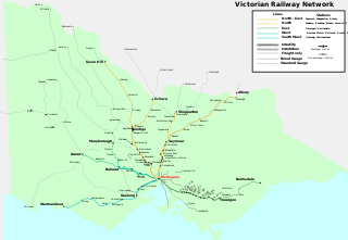
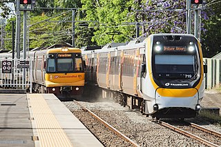
Rail transport in the Australian state of Victoria is provided by a number of railway operators who operate over the government-owned railway lines. The network consists of 2,357 km of Victorian broad gauge lines, and 1,912 km of standard gauge freight and interstate lines; the latter increasing with gauge conversion of the former. Historically, a few experimental 762 mm gauge lines were built, along with various private logging, mining and industrial railways. The rail network radiates from the state capital, Melbourne, with main interstate links to Sydney and to Adelaide, as well as major lines running to regional centres, upgraded as part of the Regional Fast Rail project.

The rail network in Adelaide, South Australia, consists of four lines and 89 stations, totalling 132 km (82 mi). It is operated by Keolis Downer under contract from the Government of South Australia, and is part of the citywide Adelaide Metro public transport system.

The State Railway of Thailand (SRT) is the state-owned rail operator under the jurisdiction of the Ministry of Transport in Thailand.
The Midland line is a suburban rail service on the Transperth network in Perth, Western Australia. It runs on the Eastern Railway through Perth's eastern suburbs and connects Midland with Perth. Travelling from Midland, the trains terminate at Fremantle on the Fremantle line.

The Australian Rail Track Corporation (ARTC) is an Australian Government-owned statutory corporation.
The Main Western Railway is a major railway in New South Wales, Australia. It runs through the Blue Mountains, and Central West regions. It is 825 kilometres (513 mi) long, of which 484 kilometres (301 mi) is currently operational.

Stockinbingal is a town in the South West Slopes and Riverina regions of New South Wales, Australia. The town is in the Cootamundra–Gundagai Regional Council local government area and on the Burley Griffin Way. At the 2016 census, Stockinbingal had a population of 374.

Bethungra is a locality in Junee Shire in the South West Slopes region of New South Wales, Australia situated on the Olympic Highway about 13 kilometres northeast of Illabo and 24 kilometres southwest of Cootamundra.
The Troy Junction–Merrygoen railway line is a railway line in northern New South Wales, Australia. It forms part of a cross country railway line between Dubbo in the state's Central West, and Werris Creek on the Main North line, allowing goods from the west of the state to access the Hunter ports, bypassing Sydney.

Jennings is a town on the Northern Tablelands region of New South Wales, Australia. The town is located in the Tenterfield Shire local government area, 718 kilometres (446 mi) from the state capital, Sydney and 256 kilometres (159 mi) from Brisbane. It is separated by the state border from its neighbouring town of Wallangarra in Queensland. At the 2011 census, Jennings had a population of 211. The New England Highway and the Main North railway line cross the state border at Jennings. The town was named for Sir Patrick Jennings, the first Roman Catholic Premier of New South Wales.

VicTrack, trading as the Victorian Rail Track Corporation, is a Victorian Government state-owned enterprise which owns all railway and tram lines, associated rail lands and other rail-related infrastructure in the state of Victoria, Australia, with the exception of the Emerald Tourist Railway Board's heritage Puffing Billy Railway.
The Western standard gauge railway line is a standard-gauge railway line in western Victoria, Australia. Completed in 1995, it forms part of the Melbourne–Adelaide rail corridor and serves as the principal interstate rail link between Victoria and the western states. The line replaced a number of former broad gauge routes which were gauge converted, and today sees both intrastate and interstate freight traffic, as well as the twice weekly The Overland passenger service. Major towns on the route include Geelong, Ararat, Horsham and Dimboola.

Parattah is a small township in Tasmania, located approximately 6 kilometres (4 mi) southeast of the town of Oatlands. At the 2011 census, Parattah had a population of 360.
The Adelaide–Wolseley railway line is a 313 kilometre line running from Adelaide to Wolseley on the Australian Rail Track Corporation network. It is the South Australian section of the Melbourne–Adelaide railway.

The Crystal Brook–Broken Hill railway line is a 371 kilometre line running from Crystal Brook to Broken Hill on the Australian Rail Track Corporation network.

Ardglen is a village on the Main North railway line and close to the New England Highway on the North West Slopes region of New South Wales, Australia.
The Murray Basin Rail Project is a major railway project in the north-west of Victoria, Australia. The project includes the conversion of a substantial portion of the Victorian freight rail network from the historical broad gauge to the standard gauge used in other parts of Australia, and the upgrading of track to enable higher axle loads for more efficient intrastate freight transfer.
Biamble is a civil parish of Napier County, New South Wales, that is located at 31°43′54″S 149°19′04″E. The civil parish is roughly equivalent to the rural locality of Neilrex in Warrumbungle Shire Council.

