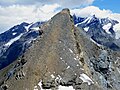
The Alpine region of Switzerland, conventionally referred to as the Swiss Alps, represents a major natural feature of the country and is, along with the Swiss Plateau and the Swiss portion of the Jura Mountains, one of its three main physiographic regions. The Swiss Alps extend over both the Western Alps and the Eastern Alps, encompassing an area sometimes called Central Alps. While the northern ranges from the Bernese Alps to the Appenzell Alps are entirely in Switzerland, the southern ranges from the Mont Blanc massif to the Bernina massif are shared with other countries such as France, Italy, Austria and Liechtenstein.

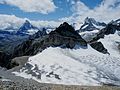
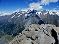
The Matterhorn is a mountain of the Alps, straddling the main watershed and border between Italy and Switzerland. It is a large, near-symmetric pyramidal peak in the extended Monte Rosa area of the Pennine Alps, whose summit is 4,478 metres (14,692 ft) above sea level, making it one of the highest summits in the Alps and Europe. The four steep faces, rising above the surrounding glaciers, face the four compass points and are split by the Hörnli, Furggen, Leone/Lion, and Zmutt ridges. The mountain overlooks the Swiss town of Zermatt, in the canton of Valais, to the northeast; and the Italian town of Breuil-Cervinia in the Aosta Valley to the south. Just east of the Matterhorn is Theodul Pass, the main passage between the two valleys on its north and south sides, which has been a trade route since the Roman Era.

Zermatt is a municipality in the district of Visp in the German-speaking section of the canton of Valais in Switzerland. It has a year-round population of about 5,800 and is classified as a town by the Swiss Federal Statistical Office (FSO).

The Dent Blanche is a mountain in the Pennine Alps, lying in the canton of Valais in Switzerland. At 4,357 m (14,295 ft)-high, it is one of the highest peaks in the Alps.

The Haute Route is the name given to a route undertaken on foot or by ski touring between the Mont Blanc in Chamonix, France, and the Matterhorn, in Zermatt, Switzerland.

Monte Rosa is a mountain massif in the eastern part of the Pennine Alps, on the border between Italy and Switzerland (Valais). The highest peak of the massif, amongst several peaks of over 4,000 m (13,000 ft), is the Dufourspitze, the second highest mountain in the Alps and western Europe, after Mont Blanc. The east face of the Monte Rosa towards Italy has a height of about 2,400 metres (7,900 ft) and is the highest mountain wall of the Alps.

The Dom is a mountain of the Pennine Alps, located between Randa and Saas-Fee in the canton of Valais in Switzerland. With a height of 4,546 m (14,915 ft), it is the seventh highest summit in the Alps, overall. Based on prominence, it can be regarded as the third highest mountain in the Alps, and the second highest in Switzerland, after Monte Rosa. The Dom is the main summit of the Mischabel group, which is the highest massif lying entirely in Switzerland.

The Ober Gabelhorn is a mountain in the Pennine Alps in Switzerland, located between Zermatt and Zinal.

The Zinalrothorn is a mountain in the Pennine Alps in Switzerland. Its name comes from the village of Zinal lying on the north side and from the German word Rothorn which means Red Peak. When it was first climbed in 1864 the mountain was known locally as Moming.

The Gornergrat is a rocky ridge of the Pennine Alps, overlooking the Gorner Glacier south-east of Zermatt in Switzerland. It can be reached from Zermatt by the Gornergrat rack railway (GGB), the highest open-air railway in Europe. Between the Gornergrat railway station and the summit is the Kulm Hotel. In the late 1960s two astronomical observatories were installed in the two towers of the Kulmhotel Gornergrat. The project “Stellarium Gornergrat” is hosted in the Gornergrat South Observatory.
Dora Keen was an American traveler, Alpinist, and social worker. She was the first person to reach the summit of Mount Blackburn and would subsequently write an article for The Saturday Evening Post titled "First up Mount Blackburn", along with becoming a fellow of the Royal Geographical Society.

The Weisshorn is a major peak of Switzerland and the Alps, culminating at 4,505 metres above sea level. It is part of the Pennine Alps and is located between the valleys of Anniviers and Zermatt in the canton of Valais. In the latter valley, the Weisshorn is one of the many 4000ers surrounding Zermatt, with Monte Rosa and the Matterhorn.
Lord Francis William Bouverie Douglas was a novice British mountaineer. After sharing in the first ascent of the Matterhorn, he died in a fall on the way down from the summit.

The Bettmerhorn is a mountain of the Bernese Alps, located north of Bettmeralp in the Swiss canton of Valais. The summit can be reached with a 30-minute vertical hike after ascending most of the mountain by cable car from the car free village of Bettmeralp. Bettmeralp is accessible by cable car from the Betten train station.

The Oberrothorn is a mountain of the Swiss Pennine Alps, overlooking Zermatt in the canton of Valais. Its summit can be easily reached via a trail on its southern flank, from the Unterrothorn cable car station or from Sunnegga.

The Schönbiel Hut is a mountain hut located north of the Matterhorn. It is situated at 2,694 metres (8,839 ft) above sea level, north of the Zmutt Glacier, a few kilometers west of the town of Zermatt in the canton of Valais in Switzerland. The actual hut was built by the Swiss Alpine Club in 1955, after the demolition of an older hut, built in 1909.
Ernest Farquet is a Swiss ski mountaineer.
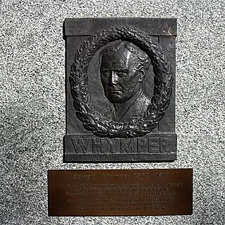
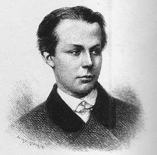
The first ascent of the Matterhorn was a mountaineering expedition made by Edward Whymper, Lord Francis Douglas, Charles Hudson, Douglas Hadow, Michel Croz, and two Zermatt guides, Peter Taugwalder and his son of the same name, on 14 July 1865. Douglas, Hudson, Hadow and Croz were killed on the descent when Hadow slipped and pulled the other three with him down the north face. Whymper and the Taugwalder guides, who survived, were later accused of having cut the rope below to ensure that they were not dragged down with the others, but the subsequent inquiry found no evidence of this and they were acquitted.
Andreas Steindl is a Swiss mountain climber, ski mountaineer and mountain guide.