
A ZIP Code is a system of postal codes used by the United States Postal Service (USPS). The term ZIP was chosen to suggest that the mail travels more efficiently and quickly when senders use the code in the postal address.

North Bass Island is an island of the U.S. state of Ohio located in Lake Erie. A small unincorporated community, Isle Saint George, is on the island. The North Bass Island Post Office was established on May 25, 1864, and the name changed to Isle Saint George Post Office on March 2, 1874. The Isle Saint George ZIP code 43436 provides PO Box service. The island is equidistant to Port Clinton, OH and Kingsville, Ontario, Canada.

Lees Creek, also known as Centerville, is an unincorporated community in central Wayne Township, Clinton County, Ohio, United States. It lies at the intersection of State Route 729 with Cox Road, 6 miles south of Sabina and 12 miles (19 km) southeast of Wilmington, the county seat of Clinton County. It lies between the headwaters of the Middle Fork of Lees Creek, to the southeast, and the Anderson Fork of Caesar Creek. it had a post office, with the ZIP code 45138. The Post Office closed in 2012 and the town, including East Clinton High School, now carries a Sabina mailing address.

Marathon is an unincorporated community and Census-designated place in northeastern Jackson Township, Clermont County, Ohio, United States. Although it is unincorporated, it had a post office, with the ZIP code 45145. The current ZIP code is 45118. It lies along U.S. Route 50.
Langsville is an unincorporated community in western Rutland Township, Meigs County, Ohio, United States, along Leading Creek. Although it is unincorporated, it has the ZIP code 45741.

North Lima is an unincorporated community and census-designated place in eastern Beaver Township, Mahoning County, Ohio, United States. The population was 1,369 at the 2020 census. Located at the intersection of State Routes 7, 164, and 165, it is part of the Youngstown–Warren metropolitan area.

Greenford is an unincorporated community in central Green Township, Mahoning County, Ohio, United States. The community lies along State Route 165 a short distance north of Salem. It is part of the Youngstown–Warren metropolitan area.

East Springfield is a census-designated place (CDP) in northwestern Salem Township, Jefferson County, Ohio, United States. It has a post office with the ZIP code 43925. It lies along State Route 43, 16 miles (26 km) northwest of the county seat of Steubenville and 17 miles (27 km) southeast of Carrollton. The community is part of the Weirton–Steubenville, WV-OH Metropolitan Statistical Area.

Mount Saint Joseph is an unincorporated community in central Delhi Township, Hamilton County, Ohio, United States. It has a post office with the ZIP code 45051. Because it includes the motherhouse of the Sisters of Charity of Cincinnati, the Internal Revenue Service recognizes 45051 as the eighth most generous ZIP code in the United States, with residents giving 41.50% of their net income to charity. The unincorporated community is also home to the Mount St. Joseph University.

West Point is an unincorporated community in northern Madison Township, Columbiana County, Ohio, United States. A former coal town, it lies along U.S. Route 30 at its intersection with State Routes 45 and 518, it has the ZIP code 44492. It is part of the Salem micropolitan area.
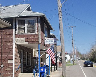
Kensington is an unincorporated community in southwestern Hanover Township, Columbiana County, Ohio, United States. Lying along U.S. Route 30 at its intersection with Ohio State Routes 9 and 644, it has a post office with the ZIP code 44427. Kensington is a part of the Salem micropolitan area, 23 miles (37 km) miles east of Canton and 30 miles (48 km) southwest of Youngstown.

East Rochester is an unincorporated community and census-designated place (CDP) in southern West Township, Columbiana County, Ohio, United States. The population was 224 as of the 2020 census. It lies along U.S. Route 30, and has a post office with the ZIP code 44625. It is a part of the Salem micropolitan area, about 20 miles (32 km) east of Canton.

Shade is an unincorporated community in southern Lodi Township, Athens County, Ohio, United States. It has a post office with the ZIP code 45776. It lies along U.S. Route 33.

New Marshfield is a census-designated place in central Waterloo Township, Athens County, Ohio, United States. The population was 316 at the 2020 census. It has a post office with the ZIP code 45766. It is located along State Route 56 west of the county seat of Athens.

Carbondale is an unincorporated community in northwestern Waterloo Township, Athens County, Ohio, United States. It has a post office with the ZIP code 45717. It is located a short distance north of State Route 56.

Middlebranch is a census-designated place in northeastern Plain Township, Stark County, Ohio, United States. It is located about 7 miles Northeast of Canton. It has a post office with the ZIP code 44652. The community is part of the Canton–Massillon Metropolitan Statistical Area. The population was 2,117 at the 2020 census. Trains from the Wheeling and Lake Erie Railway often run through the area carrying loads of scrap metal bound for other Ohio cities.

Southington is an unincorporated community in central Southington Township, Trumbull County, Ohio, United States. It lies at the intersection of U.S. Route 422 with State Route 305 and has a post office with the ZIP code 44470. It is part of the Youngstown–Warren metropolitan area.

North Bloomfield is an unincorporated community in central Bloomfield Township, Trumbull County, Ohio, United States. It lies at the intersection of State Routes 45 and 87 and has a post office with the ZIP code 44450. It is part of the Youngstown–Warren metropolitan area.
Isle St. George or Isle Saint George is an unincorporated community in Put-in-Bay Township, Ottawa County, Ohio, United States. It is the only community on North Bass Island in Lake Erie. The North Bass Island Post Office was established on May 25, 1864, and the name changed to Isle Saint George Post Office on March 2, 1874. The Isle Saint George ZIP code 43436 provides PO Box service.
Cromwell is an unincorporated community in Ohio County, Kentucky, United States.

