Clay Center, Ohio

Last updated

Clay Center, Ohio
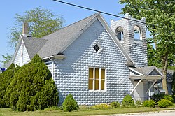
Clay Center Presbyterian Church.jpg
Presbyterian church
OHMap-doton-Clay Center.png
Location of Clay Center, Ohio
Map of Ottawa County Ohio Highlighting Clay Center Village.png
Location of Clay Center in Ottawa County
Coordinates: 41°34′23″N83°21′51″W / 41.57306°N 83.36417°W / 41.57306; -83.36417
Country United States
State Ohio
County Ottawa
Area
[1]
  Total1.01 sq mi (2.62 km2)
  Land1.01 sq mi (2.62 km2)
  Water0.00 sq mi (0.00 km2)
Elevation
[2]
453 ft (138 m)
Population
 (2020)
  Total262
  Estimate 
(2023) [3]
251
  Density258.64/sq mi (99.82/km2)
Time zone UTC-5 (Eastern (EST))
  Summer (DST) UTC-4 (EDT)
ZIP code
43408
Area code 419
FIPS code 39-15588 [4]
GNIS feature ID2397636 [2]

Clay Center is a village in Ottawa County, Ohio, United States. The population was 262 at the 2020 census.

Contents

History

Clay Center derives its name from originally being the center of a larger Clay Township. [5] When Ottawa County was founded in 1840, Allen Township did not exist, but was the northern half of a larger Clay Township. When the Townships split in 1888, Clay Center became a part of Allen Township.

The town was founded by William Clark, a land speculator who believed a town in the center of the large township would be more likely to grow than the southern population center, Genoa. In 1883 Clay Township and Genoa discussed building a new Town Hall, and it was decided that Clay Township would help construct the building in downtown Genoa, instead of the geographic center in Clay Center.[ citation needed ] Local tradition states that this was the reason for Clay Township splitting in two a few years later.[ citation needed ]

Geography

According to the United States Census Bureau, the village has a total area of 1.04 square miles (2.69 km2), all land. [6]

Demographics

Historical population
CensusPop.Note
1880 147
1950 590
1960 446−24.4%
1970 370−17.0%
1980 327−11.6%
1990 289−11.6%
2000 2941.7%
2010 276−6.1%
2020 262−5.1%
2023 (est.)251 [3] −4.2%
U.S. Decennial Census [7]

2010 census

As of the census [8] of 2010, there were 276 people, 103 households, and 74 families living in the village. The population density was 265.4 inhabitants per square mile (102.5/km2). There were 114 housing units at an average density of 109.6 per square mile (42.3/km2). The racial makeup of the village was 98.2% White, 1.1% from other races, and 0.7% from two or more races. Hispanic or Latino of any race were 5.8% of the population.

There were 103 households, of which 35.0% had children under the age of 18 living with them, 50.5% were married couples living together, 11.7% had a female householder with no husband present, 9.7% had a male householder with no wife present, and 28.2% were non-families. 24.3% of all households were made up of individuals, and 14.6% had someone living alone who was 65 years of age or older. The average household size was 2.68 and the average family size was 3.20.

The median age in the village was 32.8 years. 26.4% of residents were under the age of 18; 11.3% were between the ages of 18 and 24; 26.1% were from 25 to 44; 21.8% were from 45 to 64; and 14.5% were 65 years of age or older. The gender makeup of the village was 46.0% male and 54.0% female.

2000 census

As of the census [4] of 2000, there were 294 people, 109 households, and 84 families living in the village. The population density was 325.6 inhabitants per square mile (125.7/km2). There were 113 housing units at an average density of 125.2 per square mile (48.3/km2). The racial makeup of the village was 98.30% White, 1.70% from other races. Hispanic or Latino of any race were 4.42% of the population.

There were 109 households, out of which 35.8% had children under the age of 18 living with them, 58.7% were married couples living together, 14.7% had a female householder with no husband present, and 22.9% were non-families. 20.2% of all households were made up of individuals, and 11.9% had someone living alone who was 65 years of age or older. The average household size was 2.70 and the average family size was 3.13.

In the village, the population was spread out, with 28.2% under the age of 18, 8.5% from 18 to 24, 29.6% from 25 to 44, 23.1% from 45 to 64, and 10.5% who were 65 years of age or older. The median age was 35 years. For every 100 females there were 97.3 males. For every 100 females age 18 and over, there were 88.4 males.

The median income for a household in the village was $55,000, and the median income for a family was $55,375. Males had a median income of $40,714 versus $27,813 for females. The per capita income for the village was $22,180. About 1.1% of families and 3.0% of the population were below the poverty line, including 4.6% of those under the age of eighteen and none of those 65 or over.
Related Research Articles

<span class="mw-page-title-main">Cridersville, Ohio</span> Village in Ohio, United States

Cridersville is a village in Auglaize County, Ohio, United States. The population was 1,791 at the 2020 census. It is included in the Wapakoneta, Ohio Micropolitan Statistical Area.

<span class="mw-page-title-main">Fayetteville, Ohio</span> Village in Ohio, United States

Fayetteville is a village in Perry Township, Brown County, Ohio, United States. The population was 317 at the 2020 census.

<span class="mw-page-title-main">Somerville, Ohio</span> Census-designated place in Ohio, United States

Somerville is a census-designated place (CDP) and former village in Milford Township, Butler County, Ohio, United States. The population was 258 at the 2020 census.

<span class="mw-page-title-main">Hicksville, Ohio</span> Village in Ohio, United States

Hicksville is a village in Defiance County, Ohio, United States. The population was 3,431 at the 2020 census. It sits approximately 2.2 miles east of the Ohio-Indiana border.

<span class="mw-page-title-main">Newtown, Ohio</span> Village in Ohio, United States

Newtown is a village in southeastern Hamilton County, Ohio, United States, near Cincinnati. The population was 2,702 at the 2020 census. Newtown was settled in 1792 and incorporated as a village in 1901.

<span class="mw-page-title-main">Liberty Center, Ohio</span> Village in Ohio, United States

Liberty Center is a village in Henry County, Ohio, United States. The population was 1,108 at the 2020 census.

<span class="mw-page-title-main">Wakeman, Ohio</span> Village in Ohio, United States

Wakeman is a village in Huron County, Ohio, United States, along the Vermilion River. Its namesake was Jesup Wakeman, an early settler of Fairfield County, Connecticut, who was involved in western land speculation between 1800 and 1840. The population was 990 at the 2020 census.

<span class="mw-page-title-main">Spencer, Ohio</span> Village in Ohio, United States

Spencer is a village in Spencer Township located in Medina County, Ohio, United States. The population was 684 at the 2020 census.

<span class="mw-page-title-main">Genoa, Ohio</span> Village in Ohio, United States

Genoa is a village in Ottawa County, Ohio, United States. The population was 2,232 at the 2020 census. Originally settled as Stony Ridge, it took its present name in 1856 and was incorporated as a village on September 7, 1868.

<span class="mw-page-title-main">Commercial Point, Ohio</span> Village in Ohio, United States

Commercial Point is a village in Pickaway County, Ohio, United States. The population was 3,078 at the 2020 census. It is the fastest-growing affluent community in Pickaway County and one of the fastest-growing villages in central Ohio. It is a suburb of Columbus, OH. According to the census data of 2020, Commercial Point village has the highest household income in Pickaway county.

<span class="mw-page-title-main">Rosemount, Ohio</span> Census-designated place in Ohio, United States

Rosemount is a census-designated place (CDP) in Clay Township, Scioto County, Ohio, United States. The population was 2,117 at the 2020 census.

<span class="mw-page-title-main">Milford Center, Ohio</span> Village in Ohio, United States

Milford Center is a village in Union County, Ohio, United States. The population was 807 at the 2020 census.

<span class="mw-page-title-main">Unionville Center, Ohio</span> Village in Ohio, United States

Unionville Center is a village in Union County, Ohio, in the United States. The population was 241 at the 2020 census.

<span class="mw-page-title-main">Butlerville, Ohio</span> Village in Ohio, United States

Butlerville is a village in central Harlan Township, Warren County, Ohio, United States, located in the southwestern part of the state. The population was 155 at the 2020 census.

<span class="mw-page-title-main">Morrow, Ohio</span> Village in Ohio, United States

Morrow is a village in Salem Township, Warren County, Ohio, United States. The population was 2,049 at the 2020 census.

<span class="mw-page-title-main">Millbury, Ohio</span> Village in Ohio, United States

Millbury is a village in Wood County, Ohio, United States. The population was 1,193 at the 2020 census.

<span class="mw-page-title-main">Milton Center, Ohio</span> Village in Ohio, United States

Milton Center is a village in Wood County, Ohio, United States. The population was 137 at the 2020 census.

<span class="mw-page-title-main">Sardinia, Ohio</span> Village in Ohio, United States

Sardinia is a village in Brown and Highland counties in the U.S. state of Ohio. The population was 1,083 at the 2020 census.

<span class="mw-page-title-main">Lynchburg, Ohio</span> Village in Ohio, United States

Lynchburg is a village in Clinton and Highland counties in the U.S. state of Ohio. The population was 1,510 at the 2020 census.

<span class="mw-page-title-main">Buckeye Lake, Ohio</span> Village in Ohio, United States

Buckeye Lake is a village in Fairfield and Licking counties in the U.S. state of Ohio. The population was 2,520 at the 2020 census. It is named for Buckeye Lake, a large lake along which the village is built.

References

  1. "ArcGIS REST Services Directory". United States Census Bureau. Retrieved September 20, 2022.
  2. 1 2 U.S. Geological Survey Geographic Names Information System: Clay Center, Ohio
  3. 1 2 "Annual Estimates of the Resident Population for Incorporated Places in Ohio: April 1, 2020 to July 1, 2023". United States Census Bureau. Retrieved June 11, 2024.
  4. 1 2 "U.S. Census website". United States Census Bureau . Retrieved January 31, 2008.
  5. Overman, William Daniel (1958). Ohio Town Names. Akron, OH: Atlantic Press. p. 29.
  6. "US Gazetteer files 2010". United States Census Bureau. Archived from the original on January 25, 2012. Retrieved January 6, 2013.
  7. "Census of Population and Housing". Census.gov. Retrieved June 4, 2015.
  8. "U.S. Census website". United States Census Bureau . Retrieved January 6, 2013.