Loyalhanna Creek is a 50-mile (80 km) long tributary of the Kiskiminetas River in Westmoreland County in the U.S. state of Pennsylvania. The stream is a popular destination for canoeing and recreational trout fishing.
Red Clay Creek is a 12.7-mile-long (20.4 km) tributary of White Clay Creek, running through southeastern Pennsylvania and northern Delaware in the United States. As of 2000, portions of the creek are under wildlife habitat protection.

Slippery Rock Creek is a stream in western Pennsylvania, a tributary of Connoquenessing Creek.
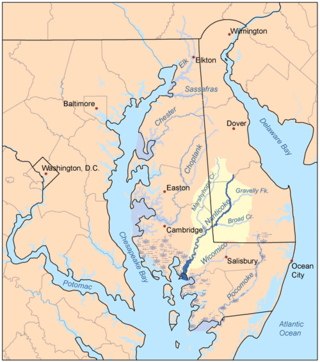
Marshyhope Creek is a 37.0-mile-long (59.5 km) tributary of the Nanticoke River on the Delmarva Peninsula. It rises in Kent County, Delaware, and runs through Caroline County, Maryland, and Dorchester County, Maryland.

The Shenango River is a principal tributary of the Beaver River, approximately 100 mi (160 km) long, in western Pennsylvania in the United States. It also briefly flows through small portions of northeastern Ohio. Via the Beaver and Ohio Rivers, it is part of the watershed of the Mississippi River.
The Mitchell River is a tributary of the Yadkin River in northwestern North Carolina in the United States. Via the Yadkin it is part of the watershed of the Pee Dee River, which flows to the Atlantic Ocean. According to the Geographic Names Information System, it has also been known historically as "Mitchells River," "Mitchels River," and "Mountain Creek."
The Ararat River is a tributary of the Yadkin River in southwestern Virginia and northwestern North Carolina in the United States. Via the Yadkin it is part of the watershed of the Pee Dee River, which flows to the Atlantic Ocean.
Laurel Hill Creek is a 39.9-mile-long (64.2 km) tributary of the Casselman River that is located in Somerset County, Pennsylvania, in the United States. It is part of the Youghiogheny River watershed, flowing to the Monongahela River, the Ohio River, and ultimately the Mississippi River.
Indian Creek is a 31.0-mile-long (49.9 km) tributary of the Youghiogheny River in Fayette County, Pennsylvania in the United States.

Oil Creek is a 46.7-mile (75.2 km) tributary of the Allegheny River that is located in Venango and Crawford counties in the Commonwealth of Pennsylvania in the United States.
Twentymile Creek is a tributary of Lake Erie in Chautauqua County, New York and Erie County, Pennsylvania in the United States.

Slate Run is a 7.3-mile-long (11.7 km) tributary of Pine Creek in Tioga and Lycoming counties, Pennsylvania in the United States.
Muddy Creek is a tributary of Slippery Rock Creek in Butler and Lawrence Counties in Pennsylvania in the United States. The run is 23.2 miles (37.3 km) long, flows generally west, and its watershed is 58.2 square miles (150.7 km2) in area. Muddy Creek is the main water source for Lake Arthur in Moraine State Park.
Peters Creek is a 16.8-mile-long (27.0 km) tributary of the Monongahela River and part of the Ohio River and Mississippi River watersheds, flowing through southwestern Pennsylvania in the United States.

South Branch French Creek is a 24.2-mile (38.9 km) long tributary to French Creek in Erie County, Pennsylvania. It is classed as a 3rd order stream on the EPA waters geoviewer site.
Hell Run is a 4.5 mi (7.2 km) long tributary to Slippery Rock Creek in Lawrence County, Pennsylvania. Hell Run flows most of its distance through McConnells Mill State Park and is the only stream in Lawrence County, Pennsylvania rated as an Exceptional Value (EV) stream.
Neshannock Creek is a 25.65 mi (41.28 km) long tributary to Shenango River that forms at the confluence of Cool Spring and Otter Creek in Mercer County and then flows south to Lawrence County, Pennsylvania. This creek is known for its fly fishing at Volant, Pennsylvania.
Reedy Fork is a 43.70 mi (70.33 km) long 3rd order tributary to the Haw River, in Alamance County, North Carolina.
Mill Creek is a 11.36 mi (18.28 km) long 2nd order tributary to French Creek in Mercer and Venango County, Pennsylvania.


