
Berrien County is a county in the U.S. state of Michigan. It is located at the southwest corner of the state's Lower Peninsula, located on the shore of Lake Michigan and sharing a land border with Indiana. As of the 2020 Census, the population was 154,316. The county seat is St. Joseph.

Bainbridge Township is a civil township of Berrien County in the U.S. state of Michigan. As of the 2010 census, the township population was 2,850. It was organized in 1837. The name is a transfer from Bainbridge, New York.

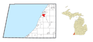
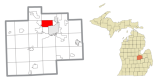
Benton Charter Township is a charter township of Berrien County in the U.S. state of Michigan. As of the 2020 census, the population was 14,374.

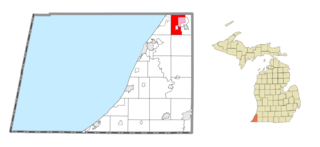
Benton Heights is an unincorporated community in Berrien County in the U.S. state of Michigan. It is also a census-designated place (CDP) for statistical purposes without any legal status as an incorporated municipality. Per the 2020 Census, the population was 3,652. The community is a part of Benton Charter Township and is adjacent to the city of Benton Harbor.
Coloma Charter Township is a charter township of Berrien County in the U.S. state of Michigan. The population was 5,020 at the 2010 census. The city of Coloma lies within the township.
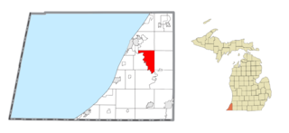
Fair Plain is an unincorporated community in Berrien County in the U.S. state of Michigan. It is a census-designated place (CDP) for statistical purposes and has no legal status as a municipality. The population was 7,631 at the 2010 census.

Royalton Township is a civil township of Berrien County in the U.S. state of Michigan, a few miles southeast of the city of St. Joseph. The population was 4,766 at the 2010 census, up from 3,888 at the 2000 census. There are no incorporated municipalities in the township, but portions are considered to be part of the Benton Harbor/St. Joseph urban area. The unincorporated communities of Hollywood, Scottdale, Arden, and Buckhorn are within the township.
Sodus Township is a civil township of Berrien County in the U.S. state of Michigan. The population was 1,932 at the 2010 census. There are no incorporated municipalities in the township. The unincorporated community of Sodus in the northwest of the township is its main settlement; the portion of the township just to the west is part of the Benton Harbor/St. Joseph urban area.

Shelby Charter Township, officially the Charter Township of Shelby, is a charter township located in Macomb County in the U.S. state of Michigan. The township is an affluent northern suburb of Detroit. As of the 2020 census, the population was 79,408, up from 73,804 in 2010. Shelby Charter Township is one of the fastest-growing communities in Metro Detroit.
Buena Vista Charter Township is a charter township of Saginaw County in the U.S. state of Michigan. Per the 2020 census, the population was 7,664.
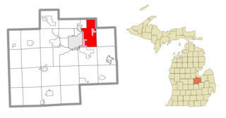
Saginaw Township North is a former census-designated place (CDP) in Saginaw County in the U.S. state of Michigan. The CDP was defined for statistical purposes and had no legal status as an incorporated municipality. The population was 24,994 at the 2000 census. The community is located within Saginaw Charter Township and consists of most of the township north of State St., while Saginaw Township South is the area south of State St. This division was purely for statistical purposes and does not reflect any present or historical self-identification of the residents in these areas.

Agency Village is an unincorporated area and census-designated place (CDP) in Roberts County, South Dakota, United States. It is the headquarters of the Sisseton Wahpeton Oyate and home to Sisseton Wahpeton College. Since 2020, the CDP includes the community known as Goodwill. The population of the CDP was 776 at the 2020 census.
Floyd Dale, shown on federal maps as Floydale, is an unincorporated community and census-designated place (CDP) in Dillon County, South Carolina, United States. It was first listed as a CDP in the 2020 census with a population of 421.
Smithtown is an unincorporated community and census-designated place (CDP) in northern Yadkin County, North Carolina, United States. It was first listed as a CDP in the 2020 census with a population of 224.
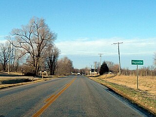
Maysville is an unincorporated community and census-designated place (CDP) in Benton County, Arkansas, United States. It is the westernmost settlement in the state of Arkansas. Per the 2020 census, the population was 117. It is located in the Northwest Arkansas region.

Lost Bridge Village is a census-designated place in Benton County, Arkansas, United States. Per the 2020 census, the population was 397. It is located in the Northwest Arkansas region.
Kirkville is a census-designated place and unincorporated community in Itawamba County, Mississippi, United States.
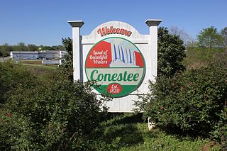
Conestee is an unincorporated community and census-designated place (CDP) in Greenville County, South Carolina, United States. It was first listed as a CDP in the 2020 census with a population of 904.

Edgartown is a census-designated place (CDP) comprising the primary settlement in the town of Edgartown, Dukes County, Massachusetts, United States, on the island of Martha's Vineyard. The CDP also includes the neighborhood of Clevelandtown.
Roberdel, also known as Roberdell, is an unincorporated community and census-designated place (CDP) in Richmond County, North Carolina, United States. It was first listed as a CDP in the 2020 census with a population of 246.

