| Millennium Park | |
|---|---|
 | |
 | |
| Type | Urban Park |
| Location | West Roxbury, Boston, Massachusetts |
| Area | 100 acres |
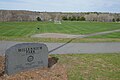
Millennium Park is a 100 acre urban park in the West Roxbury neighborhood of Boston, Massachusetts.
| Millennium Park | |
|---|---|
| | |
| | |
| Type | Urban Park |
| Location | West Roxbury, Boston, Massachusetts |
| Area | 100 acres |
Millennium Park is a 100 acre urban park in the West Roxbury neighborhood of Boston, Massachusetts.
The park began as the Gardner Street Landfill for the city of Boston. Construction began in 1994 to reclaim the area as a park using land excavated in the Big Dig, and it was officially opened on December 7, 2000 by then Mayor Tom Menino. [1]
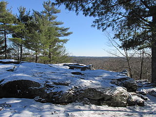
The park is well connected to neighboring parks and trails. It is adjacent to the Brook Farm Historical site and the Upper Charles River Reservation, and is close to the VFW Parkway. [2] It contains conservation land, 25 acres of sports fields, children's play areas, and a canoe launch on the Charles River.


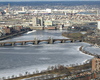
The Charles River, sometimes called the River Charles or simply the Charles, is an 80-mile-long (129 km) river in eastern Massachusetts. It flows northeast from Hopkinton to Boston along a highly meandering route, that doubles back on itself several times and travels through 23 cities and towns before reaching the Atlantic Ocean. The indigenous Massachusett named it Quinobequin, meaning "meandering" or "meandering still water".
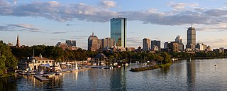
Back Bay is an officially recognized neighborhood of Boston, Massachusetts, built on reclaimed land in the Charles River basin. Construction began in 1859, as the demand for luxury housing exceeded the availability in the city at the time, and the area was fully built by around 1900. It is most famous for its rows of Victorian brownstone homes—considered one of the best preserved examples of 19th-century urban design in the United States—as well as numerous architecturally significant individual buildings, and cultural institutions such as the Boston Public Library, and Boston Architectural College. Initially conceived as a residential-only area, commercial buildings were permitted from around 1890, and Back Bay now features many office buildings, including the John Hancock Tower, Boston's tallest skyscraper. It is also considered a fashionable shopping destination and home to several major hotels.

The Public Garden, also known as Boston Public Garden, is a large park in the heart of Boston, Massachusetts, adjacent to Boston Common. It is a part of the Emerald Necklace system of parks, and is bounded by Charles Street and Boston Common to the east, Beacon Street and Beacon Hill to the north, Arlington Street and Back Bay to the west, and Boylston Street to the south. The Public Garden was the first public botanical garden in America.


The Huron–Clinton Metroparks system is a regional park system in Metro Detroit in the U.S. state of Michigan. The park system includes 13 parks totaling more than 24,000 acres (97 km2) arranged along the Huron River and Clinton River forming a partial ring around the metro area. Plans are in development to finish the ring by building hike/bike trails to connect all the parks as a green belt. The parks draw about 7.5 million visitors a year, down from a peak of 10 million in 2009. The park system is primarily tax-funded with a $50 million annual budget. The system provides employment for 200 full-time and part-time employees year-round and 1,000 additional summer workers. The rivers are prime fishing and canoeing streams with Delhi Metropark including a short rapids, which while runnable, is the only point other than dams on either stream normally portaged.
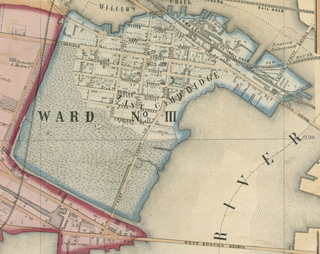
East Cambridge is a neighborhood of Cambridge, Massachusetts. East Cambridge is bounded by the Charles River and the Charlestown neighborhood of Boston on the east, the Somerville border on the north, Broadway and Main Street on the south, and the railroad tracks on the west. Most of the streets form a grid aligned with Cambridge Street, which was laid out to directly connect what is now the Charles River Dam Bridge with what in 1809 was the heart of Cambridge, Harvard Square. The northern part of the grid is a roughly six by eight block residential area. Cambridge Street itself is retail commercial, along with Monsignor O'Brien Highway, the Twin Cities Plaza strip mall, and the enclosed Cambridgeside Galleria. Lechmere Square is the transportation hub for the northern side. The southern half of the grid is largely office and laboratory space for hundreds of dot-com companies, research labs and startups associated with MIT, biotechnology firms including Genzyme, Biogen and Moderna, the Athenaeum Press Building, light industry, an NRG Energy power station, and various small businesses. This half of the neighborhood is generally identified with Kendall Square. Along the waterfront are several hotels and taller apartment buildings.

The Charles River Esplanade of Boston, Massachusetts, is a state-owned park situated in the Back Bay area of the city, on the south bank of the Charles River Basin.

University Park at MIT is a mixed-use urban renewal project in Cambridge, Massachusetts, United States, occupying land near Central Square between the Massachusetts Institute of Technology (MIT) campus and the primarily residential neighborhood of Cambridgeport. It is a joint project of the City of Cambridge, MIT, and Brookfield Asset Management. It is not part of the MIT campus.

Mary Cummings Park is a 216-acre (0.87 km2) public park in Woburn and Burlington, Massachusetts located at Babylon and Whispering Hills. The former farm and estate became a park managed by the City of Boston's Park Department in 1930. Mary Cummings left the land to the City under the condition that it be kept "forever open as a public pleasure ground". Since then it has been used for day camps including "Camp Joy", "Kamp for Kidz" and "Camp Wilderness" and as a public garden for school children called "Woburn Gardens". There are also several miles of trails which are open to the public. A radio controlled model airplane club operates their aircraft on one of the open fields which they maintain.

Medfield Meadow Lots are a group of wetland meadows—Pratt Meadow, Perry Meadow, and Hinsdale Meadow—located in the Charles River floodplain within Medfield, Massachusetts, United States. The lots, totaling 16 acres (6.5 ha), are accessible by canoe or kayak only. They were acquired as an open space reserve via land donation by Henry Lee Shattuck in 1968.

Overpeck County Park is an 811-acre (3.28 km2) county park in Bergen County, New Jersey, with major sections in Leonia, Palisades Park, Ridgefield Park, and Teaneck, surrounding Overpeck Creek, a tributary of the Hackensack River.

The Muddy River is a series of brooks and ponds that runs through sections of Boston's Emerald Necklace, including along the south boundary of Brookline, Massachusetts. The river, which is narrower than most waterways designated as rivers in the United States, is a protected public recreation area surrounded by parks and hiking trails, managed by the Massachusetts Department of Conservation and Recreation.

North Point Park is an 8.5-acre (3.4 ha) park located along the left bank of the Charles River in Cambridge, Massachusetts and Boston's West End, created as mitigation for the taking of planned parkland for the construction of the Big Dig.
Bridge Island Meadows is an 80-acre (320,000 m2) nature reserve owned by The Trustees of Reservations on the floodplains of the upper Charles River in Millis, Massachusetts. The property was a 1974 gift from Dr. and Mrs. John D. Constable to the Trustees of Reservations. The property is surrounded by wetlands, and is only accessible by boat.
Noon Hill and Shattuck Reservation are adjacent open space preserves located in Medfield, Massachusetts. They are managed by the land conservation non-profit organization The Trustees of Reservations. The 200-mile (320 km) Bay Circuit Trail passes through both properties. The Town of Medfield owns conservation land adjacent to the properties.

Ten Hills is a neighborhood in the northeastern part of the city of Somerville, Massachusetts. The area is roughly wedge-shaped, about 50 acres (200,000 m2) in size, and is bounded by the Mystic River to the north, McGrath Highway to the east, and is largely separated from the rest of Somerville by Interstate 93 to the southwest. Ten Hills is next to Assembly Square in the east, and Winter Hill in the southwest. The neighborhood landscape is predominated by a single hill, the peak of which is roughly at the intersection of Temple and Putnam Roads. The Ten Hills neighborhood is located in Ward 4, Precinct 1 of the City of Somerville, which is in the 34th district of Middlesex County.
Thomas W. Danehy Park is a park in North Cambridge, Massachusetts. Its eastern entrance is at 99 Sherman Street. It is bounded on the north by the MBTA Fitchburg Line and to the west by Fresh Pond Mall.
