Sandusky County is a county located in the northwestern part of the U.S. state of Ohio. As of the 2020 census, the population was 58,896. Its county seat and largest city is Fremont. The county was formed on February 12, 1820, from portions of Huron County.
Erie County is a county located in the northern portion of the U.S. state of Ohio. As of the 2020 census, the population was 75,622. Its county seat and largest city is Sandusky. The county is named for the Erie tribe, whose name was their word for "wildcat". It was formed in 1838 from the northern third of Huron County and a portion of Sandusky County.

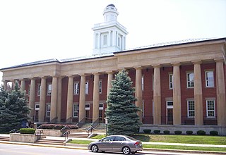
Fremont is a city in and the county seat of Sandusky County, Ohio, United States, along the Sandusky River. It is about 35 miles (56 km) southeast of Toledo and 25 miles (40 km) west of Sandusky. The population was 15,930 at the 2020 census.

Upper Sandusky is a city in and the county seat of Wyandot County, Ohio, United States, along the upper Sandusky River. The city lies approximately 59 miles (95 km) south of Toledo and 62 miles (100 km) north of Columbus. The population was 6,698 at the 2020 census.

State Route 2, formerly known as Inter-county Highway 2 until 1921 and State Highway 2 in 1922, is an east–west highway crossing most of northern Ohio. Its western terminus is at the Indiana state line near Hicksville where the route becomes Indiana State Road 37 which continues to Fort Wayne, Indiana. The eastern terminus of the route is in Painesville Township in Lake County at U.S. Route 20 (US 20).
Millerstown may refer to:

The Sandusky River is a tributary to Lake Erie in north-central Ohio in the United States. It is about 133 miles (214 km) long and flows into Lake Erie at the southwest side of Sandusky Bay.
WYNT is an adult contemporary radio station formerly located in Upper Sandusky, Ohio, now located with its studios in Marion, Ohio, and its transmitter and city of license moved to Caledonia, Ohio. It broadcasts music from the 1990s through today as "Majic 95.9" and is part of the iHeartMedia, Inc.'s Marion cluster which includes WMRN and WMRN-FM. Its Cleveland FM sister WMJI also uses the "Majic" branding for its 1960s/70s oldies station. WYNT was also formerly an oldies station under the same branding.

Northwest Ohio, or Northwestern Ohio, consists of multiple counties in the northwestern corner of the US state of Ohio. This area borders Lake Erie, Southeast Michigan, and northeastern Indiana. Some areas are also considered the Black Swamp area. The Toledo metropolitan area is part of the region.

Ballville Township is one of the twelve townships of Sandusky County, Ohio, United States. As of the 2020 census, 6,042 people lived in the township.

Rice Township is one of the twelve townships of Sandusky County, Ohio, United States. As of the 2020 census, 1,143 people lived in the township.

Riley Township is one of the twelve townships of Sandusky County, Ohio, United States. As of the 2020 census, 1,214 people lived in the township.

Sandusky Township is one of the twelve townships of Sandusky County, Ohio, United States. As of the 2020 census, 3,551 people lived in the township.
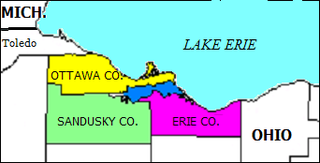
Sandusky Bay is a bay on Lake Erie in northern Ohio, formed at the mouth of the Sandusky River. It was identified as Lac Sandouské on a 1718 French map, with early variations recorded that suggest the name was derived from Native American languages. The Thomas A. Edison Memorial Bridge was constructed across it in the 20th century to connect highways in Erie and Ottawa counties.

Sandusky Township is one of the sixteen townships of Crawford County, Ohio, United States. As of the 2020 census the population was 437.

Sandusky Township is one of the eighteen townships of Richland County, Ohio, United States. It is a part of the Mansfield Metropolitan Statistical Area. The 2020 census found 1,002 people in the township.

Millerstown is an unincorporated community in eastern Johnson Township, Champaign County, Ohio, United States. It lies at the intersection of Heck Hill, Ward, and Zimmerman Roads, 2+1⁄2 miles (4.0 km) north of U.S. Route 36. Nettle Creek, a tributary of the Mad River, flows past Millerstown. It is located approximately 4 miles northeast of the city of St. Paris and 10 miles (16 km) west-northwest of the city of Urbana, the county seat of Champaign County.

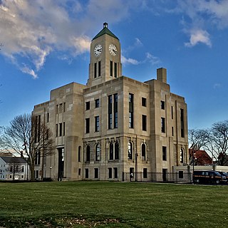
Sandusky is a city in and the county seat of Erie County, Ohio, United States. Situated along the southern shore of Lake Erie, Sandusky is located roughly midway between Toledo and Cleveland. According to 2020 census, the city had a population of 25,095, and the Sandusky metropolitan area had 115,986 residents.

U.S. Route 6 (US 6) is a part of the United States Numbered Highway System that runs from Bishop, California, to Provincetown, Massachusetts. In Ohio, the road runs west–east from the Indiana state line near Edgerton to the Pennsylvania state line near Andover. The 248.002 miles (399.121 km) that lie in Ohio are maintained by the Ohio Department of Transportation (ODOT). US 6 serves the major cities of Sandusky, Lorain, and Cleveland. The highway is also called the Grand Army of the Republic Highway to honor the Union forces of the U.S. Civil War. The alternate name was designated in 1953.

An election was held on November 6, 2018 to elect all 99 members to Ohio's House of Representatives. The election coincided with the elections for other offices, including U.S. Senate, U.S. House of Representatives, state governor and state senate. The primary election was held on May 8, 2018.

