
Spavinaw is a town in Mayes County, Oklahoma, United States. The population was 437 at the 2010 census, a decline of 22.4 percent from the figure of 563 recorded in 2000. The town is best known as the birthplace of baseball player Mickey Mantle. It is also notable for the nearby Lake Spavinaw, the principal source of water for Tulsa.

Clarkston is a town in Cache County, Utah, United States. The population was 749 at the 2020 census. It is included in the Logan, Utah-Idaho Metropolitan Statistical Area. The community celebration is held in June each year and is known as The Pony Express Days.

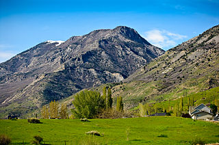
Providence is a city in Cache County, Utah, United States. The population was 8,218 at the 2020 census. It is included in the Logan, Utah-Idaho Metropolitan Statistical Area.

Panguitch is a city in and the county seat of Garfield County, Utah, United States. The population was 1,725 at the 2020 census. The name Panguitch comes from a Southern Paiute word meaning “Big Fish,” likely named after the plentiful nearby lakes hosting rainbow trout year-round.

Delta is the largest city in Millard County, Utah, United States. It is located in the northeastern area of Millard County along the Sevier River and is surrounded by farmland. The population was 3,622 at the 2020 census.

Fillmore is a city and the county seat of Millard County, Utah, United States. The population was 2,592 at the 2020 United States Census. It is named for the thirteenth U.S. President Millard Fillmore, who was in office when Millard County was created by the Utah Territorial legislature.

Magna is a city in Salt Lake County, Utah, United States. The current population of the city stands at 29,251 according to the 2020 census, a 10.4% increase over 26,505 in 2010.

Monticello is a city located in San Juan County, Utah, United States and is the county seat. It is the second most populous city in San Juan County, with a population of 1,972 at the 2010 census. The Monticello area was settled in July 1887 by pioneers from the Church of Jesus Christ of Latter-day Saints. Monticello, named in honor of Thomas Jefferson's estate, became the county seat in 1895 and was incorporated as a city in 1910.

American Fork is a city in north-central Utah County, Utah, United States, at the foot of Mount Timpanogos in the Wasatch Range, north from Utah Lake. This city is thirty-two miles southeast of Salt Lake City. It is part of the Provo–Orem Metropolitan Statistical Area. The population was 33,337 in 2020. The city has grown rapidly since the 1970s.

Lehi is a city in Utah County, Utah, United States. The population was 75,907 at the 2020 census, up from 47,407 in 2010, and it is the center of population of Utah. The rapid growth in Lehi is due, in part, to the rapid development of the tech industry region known as Silicon Slopes.
Lindon is a city in Utah County, Utah, United States. It is part of the Provo–Orem, Utah Metropolitan Statistical Area. The population was 10,070 at the 2010 census. In July 2019 it was estimated to be to 11,100 by the US Census Bureau.
Riverdale is a city in southern Weber County, Utah, United States. The population was 8,426 at the 2010 census. It is part of the Ogden–Clearfield, Utah Metropolitan Statistical Area.

Park City is a city in Utah, United States. Most of the city is within Summit County, with some portions extending into Wasatch County. It is considered to be part of the Wasatch Back. The city is 32 miles (51 km) southeast of downtown Salt Lake City and 20 miles (32 km) from Salt Lake City's east edge of Sugar House along Interstate 80. The population was 8,396 at the 2020 census. On average, the tourist population greatly exceeds the number of permanent residents.

Fairfield is a town in Utah County, Utah, United States. It is part of the Provo–Orem, Utah Metropolitan Statistical Area. It is located in the southwest corner of Cedar Valley about 50 miles (80 km) southwest of Salt Lake City and 5 miles (8.0 km) south of Cedar Fort on Utah State Route 73, west of Utah Lake. The population was 119 at the 2010 census.
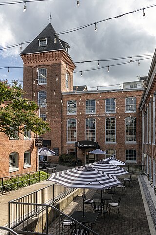
The Savage Mill is a historic cotton mill complex in Savage, Maryland, which has been turned into a complex of shops and restaurants. It was placed on the National Register of Historic Places in 1974. It is located in the Savage Mill Historic District. Buildings in the complex date from 1822 to 1916.
The Taft family is an American political family of English descent, with origins in Massachusetts. Its members have served in the states of Massachusetts, Ohio, Rhode Island, Utah, and Vermont, and the United States federal government, in various positions such as representative (two), governor of Ohio, governor of Rhode Island, senator (three), secretary of agriculture, attorney general, secretary of war (two), acting secretary of defense, president, and chief justice.
Scranton is a ghost town in Tooele County, Utah, United States. Located in Barlow Canyon near the Juab County line, it was a short-lived mining town. Scranton has been uninhabited for over a century, but some of its structures have survived relatively intact.
Eagle City is a ghost town located in Garfield County, Utah, United States. Nestled in Bromide Basin, high in the remote Henry Mountains of southern Utah, it was a gold mining camp. Eagle City was settled circa 1890, but was almost abandoned by the start of World War I. A single resident remained until the 1970s.
Williams Ranch is a ghost town located in Mills County, Texas, and is considered the oldest community in the county. It is named after John Williams, who settled there in 1855 when the area was in Brown County, Texas. The location is about 3 miles (4.8 km) south of Mullin, and 8 miles (13 km) northwest of Goldthwaite, the county seat.

Salduro is a ghost town located in Tooele County, Utah, United States.


