
Juab County is a county in western Utah, United States. As of the 2010 United States Census, the population was 10,246. Its county seat and largest city is Nephi.

Eureka is a city in Juab County, Utah, United States. It is part of the Provo–Orem metropolitan area. The population was 669 at the 2010 census, down from 766 in 2000.

Rocky Ridge is a town on the northeastern edge of Juab County, Utah, United States. As of the 2010 census it had a population of 733, and in 2018 the estimated population was 833.

Iosepa is a ghost town in the Skull Valley, located approximately 75 miles (120 km) southwest of Salt Lake City in Tooele County, Utah, United States. Once home to over 200 Polynesian members of The Church of Jesus Christ of Latter-day Saints, Iosepa was inhabited during the period 1889–1917. Today, it is the site of an annual Memorial Day gathering that draws islanders and others from all over the Western United States.
Mammoth is an unincorporated community and semi-ghost town in northeastern Juab County, Utah, United States.

Terrace is a ghost town in the Great Salt Lake Desert in west-central Box Elder County, Utah, United States.

Scranton is a ghost town in Tooele County, Utah, United States. Located in Barlow Canyon near the Juab County line, it was a short-lived mining town. Scranton has been uninhabited for over a century, but some of its structures have survived relatively intact.

Sego is a ghost town in Grand County, Utah, United States. It lies in the narrow, winding Sego Canyon, in the Book Cliffs some 5 miles (8.0 km) north of Thompson Springs. Formerly an important eastern Utah coal mining town, Sego was inhabited about 1910–1955. The town is accessed via the grade of the Ballard & Thompson Railroad, a spur from the Denver and Rio Grande Western built by the founders of the town to transport the coal.

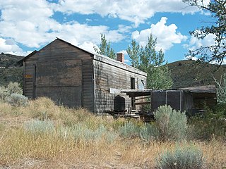
Silver City is a ghost town located at the mouth of Dragon Canyon on the west flank of the East Tintic Mountains in northeast Juab County in central Utah, United States. It was a silver mining town approximately 90 miles (140 km) south-southwest of Salt Lake City. This area was considered part of the Tintic Mining District and also produced bismuth, copper, gold, and lead. Settlement began with the first mining strikes here in 1869. Silver City was inhabited until 1930, after the mines played out. Jesse Knight, known as the "Mormon Wizard" for his ability to find ore easily, decided to build a smelter in Silver City because it had the flattest ground in all of the Tintic Mining District. Silver City had several mines in 1890, but the mines hit water and were abandoned. Now there is little left other than a few holes where mines were, and a number of tailings piles. The Silver City Cemetery, however, survives and is listed on the National Register of Historic Places.
Knightsville is a ghost town located in the East Tintic Mountains on the northern slope of Godiva Mountain, approximately 2 miles (3.2 km) east of Eureka, in the northeastern corner of Juab County in central Utah, United States. A silver mining camp, Knightsville was established and operated as a company town by local mining entrepreneur Jesse Knight. The town was inhabited from 1896 until approximately 1940.
Coal City is a ghost town in Carbon County, Utah, United States. Established in 1885, Coal City was initially a farming community until coal was discovered in the area. Small-scale mining began to take place, and because the mining operations were a mile or two away from the mines at National and Consumers, it was assumed that the citizens of the town would lack workplace stress. Coal production began to decline in 1935, and the town was essentially abandoned with just two residences occupied by the late 1960s.
Trout Creek is an unincorporated community, in far western Juab County, Utah, United States.
The East Tintic Mountains are a mountain range in central Juab, Utah, and Tooele counties in Utah, United States on the east margin of the Great Basin just west of the Wasatch Front about 50 miles (80 km) south-southeast of Salt Lake City. The community of Eureka is an old mining town near the center of the range. U.S. Route 6 Passes through the central part of the range and through Eureka.
The Juab Valley is a 40-mile (64 km) long valley located on the eastern edge of Juab County, Utah, United States.
Crystal Canyon is a canyon on the northeastern edge of Juab County, Utah, United States.
Diamond Gulch is a gulch in eastern Juab County, Utah, United States.

Currant Creek is a stream in eastern Juab County and southern Utah County in northern Utah, United States.
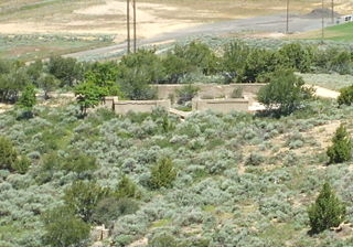
The Silver City Cemetery, is a historic cemetery in the ghost town of Silver City, Utah, United States, that dates from the 1870s and is listed on the National Register of Historic Places (NRHP).
The Tintic Smelter Site, located off U.S. Route 6 near Silver City, Utah, United States, that is listed on the National Register of Historic Places (NRHP).
The Fitch Cemetery, located west of Eureka, Utah, United States, was established in 1920 and was listed on the National Register of Historic Places in 1979.


