Tornado Alley is a loosely defined area of the central United States where tornadoes are most frequent. The term was first used in 1952 as the title of a research project to study severe weather in areas of Texas, Louisiana, Oklahoma, Kansas, South Dakota, Iowa and Nebraska. Tornado climatologists distinguish peaks in activity in certain areas and storm chasers have long recognized the Great Plains tornado belt.
On March 21–22, 1952, a severe tornado outbreak generated eleven violent tornadoes across the Southern United States, which is the fourth-largest number of F4–F5 events produced by a single outbreak. Only the 1965 Palm Sunday tornado outbreak, the 1974 Super Outbreak, and the 2011 Super Outbreak surpassed this number. The outbreak caused 209 fatalities–50 of which occurred in a single tornado in Arkansas. The severe weather event also resulted in the fourth-largest number of tornado fatalities within a 24-hour period since 1950.

The tornado outbreak of April 9–11, 2009 was a tornado outbreak that affected large portions of the Southern United States on April 9–11, 2009. At least 5 people were killed by tornadoes including three in Mena, Arkansas and two in Murfreesboro, Tennessee just south of Nashville. A total of 85 tornadoes were confirmed over the two days. Three people were killed in Texas due to wildfires caused by strong winds stemming from the same storm system. This event is sometimes referred to as the Good Friday tornado outbreak of 2009.
The May 2009 derecho series was an unusually strong sequence of derecho events and tornadoes beginning on May 2, 2009 and continuing through May 8, which primarily affected the Southern United States. At least seven people were killed by the storms. An associated tornado outbreak also resulted in nearly 100 tornadoes, some strong, with most strong tornadoes, most damage, and all of the deaths on May 8. In total, nine people were killed, dozens were injured and at least $70 million in damage occurred, $58 million on May 8.
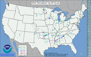
This page documents the tornadoes and tornado outbreaks of 2010. The majority of tornadoes form in the U.S., but they can occur almost anywhere under the right conditions. A lesser number occur outside the U.S., most notably in parts of neighboring southern Canada during the Northern Hemisphere's summer season, but are also known in South America, Europe, Asia, and Australia.
The April–May 2010 tornado outbreak was a multi-day tornado outbreak across a large portion of the Southern United States that occurred at the end of April and the beginning of May 2010. Five people were killed from the tornadoes – one in Arkansas, one in Tennessee, and three in Mississippi. The tornado event was overshadowed by the 2010 Tennessee floods, which occurred at the same time.

This page documents the tornadoes and tornado outbreaks of 2011. Extremely destructive tornadoes form most frequently in the United States, Bangladesh, Brazil and Eastern India, but they can occur almost anywhere under the right conditions. Tornadoes also appear regularly in neighboring southern Canada during the Northern Hemisphere's summer season, and somewhat regularly in Europe, Asia, and Australia.
From April 4–5, 2011, a large-scale damaging wind event and tornado outbreak affected the Southern and Eastern parts of the United States. The system produced a large serial derecho windstorm that caused thousands of reports of wind damage and several embedded tornadoes. Power outages were extensive across the area and tree damage was severe. Several people were killed and injured by falling trees and branches as the storm passed through. Damaging tornadoes touched down in Arkansas, Kentucky, and Mississippi. The storm continued into the early hours of the morning causing more wind damage along the East Coast along with a few more tornadoes. It is reportedly one of the most prolific damaging wind events on record. The outbreak was the first in a series of devastating tornado outbreaks in the month of April 2011, which would culminate near the end of the month with the largest tornado outbreak ever recorded.

The 2011 Super Outbreak was the largest, costliest, and one of the deadliest tornado outbreaks ever recorded, taking place in the Southern, Midwestern, and Northeastern United States and leaving catastrophic destruction in its wake. Over 175 tornadoes struck Alabama, Mississippi, and Tennessee, the most severely damaged states. Other destructive tornadoes occurred in Arkansas, Georgia, Kentucky, Louisiana, New York, and Virginia, with storms also affecting other states in the Southern and Eastern United States.

An extended period of significant tornado activity affected the Midwest and Southern United States from April 19 to April 24, 2011, with 134 tornadoes being spawned across six days. The outbreak produced an EF4 tornado that tore through the St. Louis metropolitan area on April 22, while other tornadoes caused damage in Illinois, Indiana, Ohio, Kentucky, Texas, Oklahoma, and other parts of Missouri during the period. No fatalities were reported in this outbreak. This event was directly followed by the largest tornado outbreak in the history of the United States.
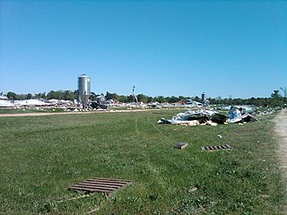
Ferguson is an unincorporated community in Phillips County, Arkansas, United States. At 6:30 PM on April 26, 2011, a tornado – part of the 2011 Super Outbreak – hit Ferguson and traveled along Arkansas Highway 44 toward Coahoma, Mississippi. The tornado was rated EF0 with winds estimated at 80 mph, a width of 200 yards (180 m), that traveled a path of 17.8 miles (28.6 km). The tornado knocked down trees, power lines, telephone poles, road signs, and irrigation facilities.
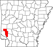
Umpire is an unincorporated community in Howard County, Arkansas, United States. It has frequently been noted on lists of unusual place names.

National Weather Service - Shreveport, LA (SHV) is one of 122 weather forecast offices around the United States. It is responsible for issuing public and aviation forecasts and warning for South Central and Southwestern Arkansas, Southeastern Oklahoma, and Eastern and Northeastern Texas Counties, as well as for North Central and Northwestern Louisiana Parishes. It is co-located with a weather radar (KSHV) of the NEXRAD network and an upper air sounding facility. It controls the issuance of weather information and bulletins on a certain number of NOAA Weather Radio.

The December 2015 North American storm complex was a major storm complex that produced a tornado outbreak, a winter storm, a blizzard and an ice storm in areas ranging from the Southwestern United States to New England. Tornadoes impacted areas around Dallas, Texas. Several states, especially Missouri, were affected by heavy rain and snow causing severe floods. As the system moved through the Great Lakes region, heavy rain, ice pellets and heavy snow fell in the entire region. Wintry mix moved through southern Ontario and Quebec had significant snowfall on December 29. Almost 60 people were killed in the storm system and its aftermath, which made it one of the deadliest of such systems of 2015 in the United States.

The tornado outbreak and floods of April 28 – May 1, 2017 were a series of severe weather events that affected the central United States, producing life-threatening flooding and a major tornado outbreak. It formed out of a disturbance in the Southwestern United States on April 28, and caused significant impacts, including a heavy snowstorm in the Rockies, and other types of severe weather. Up to 3 feet (36 in) of snow fell on the cold side of the system, and up to a foot of rain fell in and around the central parts of the nation.

The April 13–15, 2018 North American storm complex brought a wide swath of severe and winter weather that affected much of Midwest across to the East Coast of the United States. This particular outbreak led to at least 73 confirmed tornadoes over a three-day period, most of which occurred across Arkansas and Louisiana during the evening hours of April 13. The most significant tornadoes were an EF1 that caused a fatality in Red Chute, Louisiana, early on April 14, an upper-end EF2 tornado that impacted eastern sections of Greensboro, North Carolina on April 15, causing 17 injuries, and a significant EF3 tornado that impacted areas from Lynchburg to Elon, Virginia, causing severe damage and at least 10 injuries.

The tornado outbreak of January 10–11, 2020 was a two-day severe weather event stretching from the South-Central Plains eastward into the Southeast United States. An eastward-moving shortwave trough tracked across the continental United States through that two-day period, combining with abundant moisture, instability, and wind shear to promote the formation of a long-lived squall line. Hundreds of damaging wind reports were received, and 80 tornadoes occurred within this line, making it the third largest January tornado outbreak on record. Three tornadoes—an EF1 in eastern Texas, an EF2 in northern Louisiana, and an EF2 in western Alabama—led to a total of seven deaths, all in mobile homes. There were five other storm related deaths, including two due to icy roads in Lubbock, Texas, one due to drowning in Oklahoma, and one due to icy roads in Iowa.Extensive damage and several other injuries occurred as well. The severe weather event was notable in that it was forecast well in advance, with the Storm Prediction Center first highlighting the risk area a full week beforehand. Total damage from the event reached $1.1 billion according to the National Centers for Environmental Information.
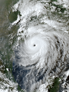
Hurricane Laura was a deadly and destructive Category 4 hurricane that is tied with the 1856 Last Island hurricane and 2021's Hurricane Ida as the strongest hurricane on record to make landfall in the U.S. state of Louisiana, as measured by maximum sustained winds. The twelfth named storm, fourth hurricane, and first major hurricane of the record-breaking 2020 Atlantic hurricane season, Laura originated from a large tropical wave that moved off the West African coast on August 16 and became a tropical depression on August 20. Laura intensified into a tropical storm a day later, becoming the earliest twelfth named storm on record in the North Atlantic basin, forming eight days earlier than 1995's Hurricane Luis.