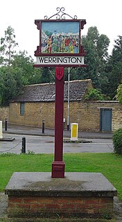
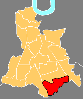
Werrington is a residential area of the city of Peterborough, in the unparished area of Peterborough, in the Peterborough district, in the ceremonial county of Cambridgeshire, England. For electoral purposes it comprises North Werrington and South Werrington wards. Werrington spans an area of two and a half square miles (6 km²) and has a population of 14,800.

Yate is a town and civil parish in South Gloucestershire, England. It lies just to the southwest of the Cotswold Hills and is 12 miles northeast of Bristol city centre and 11 miles from the centre of Bath, with regular rail links to both cities.

Cheshunt is a town in the Borough of Broxbourne, Hertfordshire, lying entirely within the London Metropolitan Area and Greater London Urban Area. The area is on the River Lea, Lee Navigation together with the New River.
Downham is a district of south-east London, England, within the London Borough of Lewisham. It borders the London Borough of Bromley, and is located north of Bromley and south of Catford.

The St. Enoch Centre is a shopping mall located in the city centre of Glasgow, Scotland. The centre is located adjacent to St Enoch Square. The Architects were the GMW Architects. The construction, undertaken by Sir Robert McAlpine, began in 1986, and the building was opened to the public on 25 May 1989. It was officially opened by the then-Prime Minister Margaret Thatcher, in February of the following year.

Immingham is a town, civil parish and ward in the North East Lincolnshire unitary authority of England. It is situated on the south-west bank of the Humber Estuary, and is 6 miles (10 km) north-west from Grimsby.

Whiteleys was a shopping centre in Bayswater, London. It was built in the retail space of the former William Whiteley Limited department store, which opened in 1911 as one of London's first department stores, and was one of the main department stores, alongside Selfridge's, Liberty's and Harrods. The centre's main entrance was located on Queensway.

Abbeydale and Abbeymead are modern suburbs of the city of Gloucester in the county of Gloucestershire, England. They lie approximately 3 miles south-east of the city centre, and are bounded by the suburbs of Coney Hill to the north west, Barnwood and Hucclecote to the north and north east, Matson to the south west and the M5 motorway to the south and east. Mostly connected with Segregated Bicycle Paths into Gloucester city along Metz Way. The village of Upton St Leonards is directly across the M5 motorway.

Southside Wandsworth is a shopping centre in the district of Wandsworth in London, England. When it was built it was the largest indoor shopping centre in Europe and is currently the fifth largest indoor shopping centre in London after Westfield Stratford, Westfield London, the Whitgift Centre and Brent Cross.

Hackney Central is a sub-district of Hackney in the London Borough of Hackney in London, England and is four miles (6.4 km) northeast of Charing Cross.

Talbot Green is a town just north of the M4 motorway, in the County Borough of Rhondda Cynon Taf, Wales in the United Kingdom. The town is part of Llantrisant Community Council.
Weavering is a village, mainly consisting of parts of the Grove Green and Bearsted Park housing Estates, centred on Weavering Street, within the borough of Maidstone, Kent in South East England that was formerly farmland. At the 2014 Census the population of the village was included in the civil parish of Thurnham.

The A4119 links Tonypandy with Cardiff in South Wales.
Ruxley is a small settlement in southeast London, England, with no present formal boundaries. It is located 21 km (13 mi) southeast by east of Charing Cross, in the northeast corner of the London Borough of Bromley on the borough boundary with the southeast corner of the London Borough of Bexley, and is also adjacent to the Greater London border with Kent, overlapping into the Sevenoaks District and Borough of Dartford in Kent. Ruxley lies east of Sidcup and west of Swanley, on green belt land, where two main roads pass through east-west connecting London to the coast. Ruxley was a parish prior to 1557 and had its own thirteenth century church, St Botolph's. Ruxley's central location on the main road made it an important meeting place for the Hundred of Ruxley, which was named after it. Today still a major transport route, Ruxley's location on green belt land is on the edge of London's urban sprawl, industrial and residential areas are found on the west side, but to the east this quickly turns into more rural woodland and farmland. Ruxley Gravel Pits is a biological Site of Special Scientific Interest located on the west side of Ruxley. Today the area is known for Ruxley Manor, a large site with a garden centre and other retailers and services.
Grove Green is a suburban housing development, partially forming a part of Weavering village, near the town of Maidstone in Kent, England. The population of the development is included in the civil parish of Boxley. The estate is also near the village of Bearsted and is convenient for the M20 motorway making its homes keenly sought after by London commuters. For young people, there is a youth group, and Grove Green Scout Group.

Hammersmith Broadway is a major transport node and shopping centre in Hammersmith, London.
Redditch is a town and local government district in north-east Worcestershire, England. The town is divided into separate districts. All street-name signs in Redditch have the street name in white lettering on a blue background and the district name in black lettering on a white background at the bottom of the sign. In the New Town areas the roads are usually named in alphabetical order and house numbering in the cul-de-sac closes is consecutive, starting with number 1 as the first house on the left as you enter, and the highest house number will be on the opposite side of the road as you leave.

The Hindpool Retail Parks are a set of four conjoined retail parks in the Hindpool area of Barrow-in-Furness, England, United Kingdom. Some thirty stores and leisure facilities contain a total of 43,000 m2 (460,000 sq ft) of retail space. The four retail parks are Cornerhouse Retail Park, Cornmill Crossing, Hindpool Retail Park and Hollywood Park. The largest and only other retail park in Barrow is Walney Road Retail Park - Pound Stretcher, Argos Extra, Asda, Home Bargains, Matalan and Stollers.

Gallions Reach Shopping Park is a major out-of-town retail park in Beckton, east London, England. Located on Armada Way beside the River Thames, Gallions Reach is the largest retail park in London and the M25, containing 34 units in an area of 324,000 square feet.

Salford Shopping Centre is a shopping centre located in Pendleton, 2 miles (3.2 km) from Manchester city centre.