Minsmere–Walberswick Heaths and Marshes

Last updated
Minsmere–Walberswick Heaths and Marshes
Site of Special Scientific Interest

Dingle marsh and Dunwich Forest - geograph.org.uk - 274585.jpg

Dingle Marshes, part of the Minsmere–Walberswick Heaths and Marshes SSSI
Suffolk UK location map.svg
Red pog.svg
Minsmere–Walberswick Heaths and Marshes within Suffolk
Area of Search Suffolk
Grid reference TM469681
Coordinates 52°15′22″N1°37′01″E / 52.256°N 1.617°E / 52.256; 1.617 Coordinates: 52°15′22″N1°37′01″E / 52.256°N 1.617°E / 52.256; 1.617
Interest Biological
Area 2,325.89 hectares (23 km2; 9.0 sq mi)
Notification 1993
Natural England website

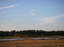
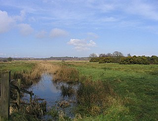
Minsmere–Walberswick Heaths and Marshes are a Special Area of Conservation and Site of Special Scientific Interest in the English county of Suffolk. [1] The site is located on the North Sea coast between Southwold and Sizewell, extending over an area of coastline around 7 miles (11 km) in length. The site is also designated as a Special Protection Area, [2] part of the Minsmere–Walberswick European Marine Site and contains areas designated as Ramsar sites and Natura 2000 sites. [3] It lies within the Suffolk Coast and Heaths Area of Outstanding Natural Beauty [4] and is made up of a "complex mosaic" of marshes, reed beds, shingle banks and lowland heath habitats. [2]

A Special Area of Conservation (SAC) is defined in the European Union's Habitats Directive (92/43/EEC), also known as the Directive on the Conservation of Natural Habitats and of Wild Fauna and Flora. They are to protect the 220 habitats and approximately 1000 species listed in annex I and II of the directive which are considered to be of European interest following criteria given in the directive. They must be chosen from the Sites of Community Importance by the State Members and designated SAC by an act assuring the conservation measures of the natural habitat.

Site of Special Scientific Interest Conservation designation denoting a protected area in the United Kingdom

A Site of Special Scientific Interest (SSSI) in Great Britain or an Area of Special Scientific Interest (ASSI) in the Isle of Man and Northern Ireland is a conservation designation denoting a protected area in the United Kingdom and Isle of Man. SSSI/ASSIs are the basic building block of site-based nature conservation legislation and most other legal nature/geological conservation designations in the United Kingdom are based upon them, including national nature reserves, Ramsar sites, Special Protection Areas, and Special Areas of Conservation. The acronym "SSSI" is often pronounced "triple-S I".

Suffolk County of England

Suffolk is an East Anglian county of historic origin in England. It has borders with Norfolk to the north, Cambridgeshire to the west and Essex to the south. The North Sea lies to the east. The county town is Ipswich; other important towns include Lowestoft, Bury St Edmunds, Newmarket and Felixstowe, one of the largest container ports in Europe.

Contents

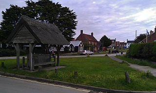
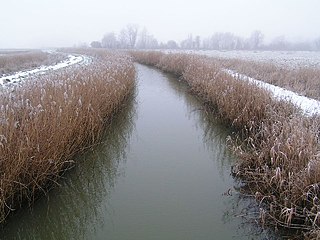
The SSSI covers an area of 2,325.89 hectares (8.98 sq mi; 23.26 km2). [5] It is a composite site and was formed by the almagamation of the Minsmere Level, Walberswick and Brick Kiln Walks SSSI units. It extends from Hen Reedbeds and Southwold Common north of the River Blyth, through Walberswick and Dunwich to Westleton, Minsmere and Eastbridge to the north of Sizewell nuclear power stations. [6] The area includes the Suffolk Coast National Nature Reserve sites at Hen Reedbeds, Walberswick and Dingle Marshes, the National Trust property at Dunwich Heath and the Minsmere RSPB reserve. It is a Nature Conservation Review site, Grade I, [7] and covers two nature reserves managed by the Suffolk Wildlife Trust, Dingle Marshes [8] and Hen Reedbeds. [9]

Hen Reedbeds Suffolk Wildlife Trust nature reserve

Hen Reedbeds is a 55 hectare nature reserve near the North Sea coast of the English county of Suffolk. The reserve is located in the Blyth valley between Reydon and Blythburgh, approximately 2.5 miles (4.0 km) west of Southwold. The marshes make up part of the Suffolk Coast National Nature Reserve along with reserves at Walberswick and Dingle Marshes.

Southwold town in Suffolk, England

Southwold is a small town and civil parish on the English North Sea coast in the East Suffolk district of Suffolk. It lies at the mouth of the River Blyth within the Suffolk Coast and Heaths Area of Outstanding Natural Beauty. The town is about 11 miles (18 km) south of Lowestoft, 29 miles (47 km) north-east of Ipswich and 97 miles (156 km) north-east of London, within the parliamentary constituency of Suffolk Coastal. The "All Usual Residents" 2011 Census figure gives a total of 1,098 persons for the town. The 2012 Housing Report by the Southwold and Reydon Society concluded that 49 per cent of the dwellings in the town are used as second homes and let to holiday-makers.

River Blyth, Suffolk river in east Suffolk, England

The River Blyth is a river in east Suffolk, England. Its source is near Laxfield and it reaches a tidal estuary between Southwold and Walberswick on the North Sea coast.

Special Area of Conservation

The Special Area of Conservation is 1,265.52 hectares (4.89 sq mi; 12.66 km2) in area and extends from south of the River Blyth at Walberswick to Westleton and Minsmere to the south where it includes the Minsmere RSPB reserve and marshes alongside the Minsmere River. [10] This area includes a range of habitats, including lowland heath and shingle beach vegetation. [1]

Walberswick human settlement in United Kingdom

Walberswick is a village and civil parish on the Suffolk coast in England. It is at the mouth of the River Blyth on the south side of the river. The town of Southwold lies to the north of the river and is the nearest town to Walberswick, around 1 mile (1.6 km) away. Walberswick is around 11 miles (18 km) south of Lowestoft on the North Sea coast. It is 7 miles (11 km) east of Halesworth and 28 miles (45 km) north-east of the county town of Ipswich.

Westleton village in the United Kingdom

Westleton is a village and civil parish in the English county of Suffolk. It is located 4 miles (6 km) north of Leiston and 5 miles (8 km) north-east of Saxmundham near the North Sea coast. The village is on the edge of the Suffolk Sandlings, an area of lowland heathland. The village lies along the B1125 road, 2 miles (3 km) to the east of the A12 and Darsham railway station.

Minsmere village in the United Kingdom

Minsmere is a place in the English county of Suffolk. It is located on the North Sea coast around 3.5 miles (5.6 km) north of Leiston and 1.5 miles (2.4 km) south-east of Westleton within the Suffolk Coast and Heaths AONB. It is the site of the Minsmere RSPB reserve and the original site of Leiston Abbey.

Related Research Articles

Suffolk Coast and Heaths

The Suffolk Coast and Heaths AONB is an Area of Outstanding Natural Beauty in Suffolk, England.

RSPB Minsmere RSPB nature reserve in the United Kingdom

RSPB Minsmere is a nature reserve owned and managed by the Royal Society for the Protection of Birds (RSPB) at Minsmere, Suffolk. The 1,000-hectare (2,500-acre) site has been managed by the RSPB since 1947 and covers areas of reed bed, lowland heath, acid grassland, wet grassland, woodland and shingle vegetation. It lies within the Suffolk Coast and Heaths Area of Outstanding Natural Beauty and the Suffolk Heritage Coast area. It is conserved as a Site of Special Scientific Interest, Special Area of Conservation, Special Protection Area and Ramsar site.

Suffolk Wildlife Trust

Suffolk Wildlife Trust (SWT) describes itself as the county's "nature charity – the only organisation dedicated wholly to safeguarding Suffolk's wildlife and countryside." It is a registered charity, and its headquarters is at Brooke House in Ashbocking, near Ipswich. It was founded in 1961, and is one of 47 wildlife trusts covering the Great Britain and Northern Ireland. As of March 2017, it has 13,200 members, and it manages 3,120 hectares of land in 60 nature reserves, most of which are open to the public. It had an income of £3.9 million in the year to 31 March 2017.

Havergate Island

Havergate Island is the only island in the county of Suffolk, England. It is found at the confluence of the River Ore and the Butley River near the village of Orford. It is a marshy nature reserve run by the Royal Society for the Protection of Birds (RSPB) and is known for its population of avocets and terns. It is part of the ecologically important Alde-Ore Estuary and has protected conservation status as part of a national nature reserve, SSSI, SAC, SPA, Ramsar Site and is also a part of the Suffolk Coast and Heaths AONB.

The Sandlings Walk is a long-distance path in Suffolk, England. It runs through the Suffolk Sandling that used to stretch from the outskirts of Ipswich to Southwold which is an area of lowland heath, Britain's rarest wildlife habitat, and the Suffolk Coast and Heaths Area of Outstanding Natural Beauty.

North Warren RSPB reserve RSPB nature reserve in the United Kingdom

North Warren RSPB reserve is a nature reserve run by the Royal Society for the Protection of Birds (RSPB) in Suffolk, England. It lies on the Suffolk coast on the north edge of the town of Aldeburgh and to the south of Thorpeness and includes the Aldringham Walks area of heathland to the north. It is within the Suffolk Coast and Heaths Area of Outstanding Natural Beauty (AONB) and the Suffolk Heritage Coast area. Noted for its populations of Eurasian bittern, European nightjar and other bird species, it covers a range of coastal habitats and is protected with SSSI, SPA conservation status.

A1095 road road in England

The A1095 road is an A road in the English county of Suffolk. It runs from Southwold on the North Sea coast to the A12 London to Great Yarmouth road at Henham between Blythburgh and Wangford. It is around 4 miles (6.4 km) in length and is single carriageway throughout. The entire length of the road lies within the Suffolk Coast and Heaths Area of Outstanding Natural Beauty.

Dunwich Heath

Dunwich Heath is an area of coastal lowland heath just south of the village of Dunwich, in the Suffolk Coast and Heaths AONB. It is adjacent to the RSPB reserve at Minsmere. It lies within the area of the Minsmere-Walberswick Heaths and Marshes Site of Special Scientific Interest, Special Area of Conservation and Special Protection Area.

Trimley Marshes Suffolk Wildlife Trust nature reserve

Trimley Marshes is a 77 hectare nature reserve west of Trimley St Mary, on the outskirts of Felixstowe in Suffolk. It is managed by the Suffolk Wildlife Trust. It is in the Suffolk Coast and Heaths Area of Outstanding Natural Beauty, the Orwell Estuary Site of Special Scientific Interest, the Stour and Orwell Estuaries Ramsar site internationally important wetland site and Special Protection Area under the European Union Directive on the Conservation of Wild Birds.

Blaxhall Common Suffolk Wildlife Trust nature reserve

Blaxhall Common is a nature reserve in the parish of Blaxhall in the Suffolk Coastal district of Suffolk. The reserve is owned by Blaxhall Parish Council and managed by Suffolk Wildlife Trust. It is designated a 45.9 hectare biological Site of Special Scientific Interest as Blaxhall Heath. It is part of the Sandlings Special Protection Area under the European Union Directive on the Conservation of Wild Birds, and of the Suffolk Coast and Heaths Area of Outstanding Natural Beauty. A Bronze Age bowl barrow is a Scheduled Monument.

Dingle Marshes Suffolk Wildlife Trust and RSPB nature reserve

Dingle Marshes is a 93 hectares wildlife reserve on the North Sea coast of the English county of Suffolk. The reserve is located between Dunwich and Walberswick, approximately 4 miles (6.4 km) south-west of Southwold. The marshes make up part of the Suffolk Coast National Nature Reserve along with reserves at Walberswick and Hen Reedbeds. They are owned jointly by the RSPB and Suffolk Wildlife Trust and are managed by these two organisations and Natural England. The site is in the Dunwich Heaths and Marshes Nature Conservation Review site, Grade I, the Minsmere-Walberswick Ramsar internationally important wetland site, the Minsmere to Walberswick Heaths and Marshes Special Area of Conservation, and the Minsmere-Walberswick Special Protection Area under the European Union Directive on the Conservation of Wild Birds.

Dunwich Forest Suffolk Wildlife Trust nature reserve

Dunwich Forest is an area of forest and lowland heath around 1 mile (1.6 km) north-east of the village of Dunwich in the English county of Suffolk. The forest covers an area of around 9 square kilometres and was originally planted by the Forestry Commission. The forest is within the Suffolk Coast and Heaths Area of Outstanding Natural Beauty and is in the area known as the Suffolk Sandlings. South of the reserve is the National Trust property of Dunwich Heath, one of the largest remaining areas of lowland heath on the Suffolk coast, and the RSPB reserve at Minsmere. To the north and east of the forest are Dingle Marshes, part of the Suffolk Coast National Nature Reserve.

Sizewell Belts Suffolk Wildlife Trust nature reserve

Sizewell Marshes is a 105.4 hectare biological Site of Special Scientific Interest adjacent to Sizewell in Suffolk. It is in the Suffolk Coast and Heaths Area of Outstanding Natural Beauty, and is part of a 144 hectare nature reserve managed by the Suffolk Wildlife Trust as Sizewell Belts.

Minsmere River river in Suffolk, United Kingdom

Minsmere River is a river in the English county of Suffolk which flows into the North Sea at Minsmere. The river is formed from the River Yox at Yoxford before flowing through Middleton, Eastbridge and Minsmere. It flows to the south of Minsmere RSPB reserve helping to form many of the wetland habitats at the reserve.

Suffolk Coast National Nature Reserve

Suffolk Coast National Nature Reserve is a wildlife reserve on the North Sea coast of the English county of Suffolk. It is located around the village of Walberswick to the south of the town of Southwold. The reserve was designated in 2003, combining the existing Walberswick National Nature Reserve with reserves at Dingle Marshes and Hen Reedbeds to create a 1,340 hectares reserve.

Potton Hall Fields, Westleton

Potton Hall Fields, Westleton is a 16.7 hectare biological Site of Special Scientific Interest ( west of Dunwich in Suffolk. It is in the Suffolk Coast and Heaths Area of Outstanding Natural Beauty.

References

  1. 1 2 Minsmere to Walberswick Heaths and Marshes, Joint Nature Conservation Committee. Retrieved 2013-03-08.
  2. 1 2 Minsmere–Walberswick, Joint Nature Conservation Committee. Retrieved 2013-03-08.
  3. European site conservation objectives for Minsmere to Walberswick heaths and marshes Special Area of Conservation, Natural England. Retrieved 2013-03-08.
  4. About us, Suffolk Coast and Heaths AONB. Retrieved 2014-03-08.
  5. Minsmere–Walberswick Heaths and Marshes, SSSI citation, Natural England. Retrieved 2014-03-08.
  6. Magic map, Minsmere–Walberswick Heaths and Marshes SSSI, Magic. Retrieved 2014-03-08.
  7. Ratcliffe, Derek, ed. (1977). A Nature Conservation Review. 2. Cambridge, UK: Cambridge University Press. pp. 210–211. ISBN   0521 21403 3.
  8. "Dingle Marshes". Suffolk Wildlife Trust. Retrieved 1 May 2017.
  9. "Hen Reedbeds". Suffolk Wildlife Trust. Retrieved 4 May 2017.
  10. Magic map, Minsmere to Walberswick Heaths and Marshes SAC, Magic. Retrieved 2014-03-08.

See also