This article needs additional citations for verification .(August 2016) |
Mintlaw Trestle | |
---|---|
Coordinates | 52°12′28″N113°54′52″W / 52.20778°N 113.91444°W |
Carries | Railway |
Crosses | Red Deer River |
Locale | Mintlaw, Alberta |
Official name | Mintlaw Trestle |
Characteristics | |
Total length | 2,112 feet (644 m) |
Height | 110 ft |
Longest span | 150' truss span |
History | |
Constructed by | Alberta Central Railway |
Opened | 1912 |
Closed | 1983 |
Location | |
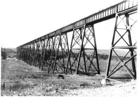
The Mintlaw Trestle is an abandoned steel and wooden railway trestle that was built over the Red Deer River by the Alberta Central Railway near Mintlaw, Alberta, in 1912. The last train to cross the bridge was in 1981, and the line and bridge was abandoned in 1983. [1] The bridge is the second longest Canadian Pacific Railway bridge of its kind in Alberta. It is the longest and the highest bridge in Central Alberta. It is located west of Tuttle, northwest of Penhold, southwest of Red Deer, northwest of Red Deer Airport, and near the intersection of the C & E Trail and McKenzie Road.
The Alberta Central Railway was incorporated in 1901 by an act of parliament in Alberta. [2] Construction by the Alberta Central Railway on the bridge started in 1911 just east of the now ghost town of Mintlaw (where a station was located) after Sir Wilfrid Laurier, the prime minister of Canada visited Red Deer to drive the first spike into the railway. The bridge was completed in the autumn of 1912. After the Alberta Central Railway went bankrupt, the bridge was leased to the Canadian Pacific Railway, and the Alberta Central Railway was eventually bought by the Canadian Pacific Railway.
The last train to go across the bridge went across in 1981 before the line was abandoned in 1983. [3] In 2009, Red Deer County purchased the bridge from the Canadian Pacific Railway for $1 as an important heritage landmark and as part of a possible future regional pedestrian and cycling trail. In late 2010, Red Deer County authorized $350,000 for maintenance on the west side of the bridge, and on the east side in 2014. [4]
The Trans Canada Trail, officially named the Great Trail between September 2016 and June 2021, is a cross-Canada system of greenways, waterways, and roadways that stretches from the Atlantic to the Pacific to the Arctic oceans. The trail extends over 24,000 km (15,000 mi); it is now the longest recreational, multi-use trail network in the world. The idea for the trail began in 1992, shortly after the Canada 125 celebrations. Since then it has been supported by donations from individuals, corporations, foundations, and all levels of government.
The Kettle Valley Railway was a subsidiary of the Canadian Pacific Railway (CPR) that operated across southern British Columbia, west of Midway running to Rock Creek, then north to Myra Canyon, down to Penticton over to Princeton, Coalmont, Brookmere, Coquihalla and finally Hope where it connected to the main CPR line.
The National Transcontinental Railway (NTR) was a historic railway between Winnipeg, Manitoba, and Moncton, New Brunswick, in Canada. Much of the line is now operated by the Canadian National Railway.
Rochfort Bridge is a hamlet in Alberta, Canada within Lac Ste. Anne County. It is located approximately 105 kilometres (65 mi) northwest of Edmonton and 8 kilometres (5.0 mi) east of Mayerthorpe. Rochfort Bridge is named for Cooper (Cowper) Rochfort, who with his associate, Percy Michaelson, homesteaded on the Paddle River at the point where the old trail from Lac Ste. Anne to the MacLeod River crossed the Paddle River.
Highway 2 is a major highway in Alberta that stretches from the Canada–United States border through Calgary and Edmonton to Grande Prairie. Running primarily north to south for approximately 1,273 kilometres (791 mi), it is the longest and busiest highway in the province carrying more than 170,000 vehicles per day near Downtown Calgary. The Fort Macleod—Edmonton section forms a portion of the CANAMEX Corridor that links Alaska to Mexico. More than half of Alberta's 4 million residents live in the Calgary–Edmonton Corridor created by Highway 2.
The Southern New England Railway was a project of the Grand Trunk Railway (GT) to build a railroad from the GT-owned Central Vermont Railway at Palmer, Massachusetts south and east to the all-weather port of Providence, Rhode Island. Much grading and construction, including many large concrete supports, was carried out, but the project was not completed.
The Sacramento Northern Railway was a 183-mile (295 km) electric interurban railway that connected Chico in northern California with Oakland via the state capital, Sacramento. In its operation it ran directly on the streets of Oakland, Sacramento, Yuba City, Chico, and Woodland. This involved multiple car trains making sharp turns at street corners and obeying traffic signals. Once in open country, SN's passenger trains ran at fairly fast speeds. With its shorter route and lower fares, the SN provided strong competition to the Southern Pacific and Western Pacific Railroad for passenger business and freight business between those two cities. North of Sacramento, both passenger and freight business was less due to the small town agricultural nature of the region and due to competition from the paralleling Southern Pacific Railroad.
Entwistle is a hamlet in Alberta, Canada, within Parkland County. It is at the Yellowhead Highway's intersection with Highway 22/Highway 16A, approximately 95 kilometres (59 mi) west of Edmonton. It sits on the east banks of the Pembina River near the halfway point between Edmonton and Edson.
The Ottawa, Arnprior and Parry Sound Railway, or OA&PS, is a historic railway that operated in central and eastern Ontario, Canada, from 1897 to 1959. It was for a time the busiest railway route in Canada, carrying both timber and wood products from today's Algonquin Provincial Park areas, as well as up to 40% of the grain traffic from the Canadian west from Depot Harbour at Parry Sound through to the St. Lawrence River valley.
The Canada Atlantic Railway (CAR) was a North American railway located in Ontario, southwestern Quebec and northern Vermont. It connected Georgian Bay on Lake Huron with the northern end of Lake Champlain via Ottawa. It was formed in 1879 through a merger of two separate railway companies that John Rudolphus Booth had purchased, and reached its full extent in 1899 through a third company that he had created. The CAR was owned by Booth for several years after its completion until he agreed to sell it to the Grand Trunk Railway (GTR) in 1904.
Mill Creek Ravine is located in Edmonton, Alberta, Canada and is a part of the River Valley parks and trail system. It contains the last stretch of Mill Creek, before it flows into a culvert for its end run to the North Saskatchewan River. The ravine ends where the land opens onto the North Saskatchewan River valley near the west end of Cloverdale on the opposite bank from downtown.
The Red Coat Trail is a 1,300-kilometre (810 mi) route that approximates the path taken in 1874 by the North-West Mounted Police in their March West from Fort Dufferin to Fort Whoop-Up.
The Dinosaur Trail is a circular tourist route in the province of Alberta, Canada, located in the Canadian badlands paralleling the Red Deer River on both sides, from Drumheller to the Bleriot Ferry. It is divided in two segments, with the South Dinosaur Trail following the south side of the river and uses portions of Highway 575 and Highway 837, while North Dinosaur Trail follows the north side of the river and is the entirety of Highway 838. The north and south segments of Dinosaur Trail are connected by the Highway 9 / Highway 56 concurrency within Drumheller.
Saskatchewan has a transportation infrastructure system of roads, highways, freeways, airports, ferries, pipelines, trails, waterways, and railway systems serving a population of approximately 1,132,505 inhabitants year-round.
The Calgary and Edmonton Railway (C&E) was an early pioneer railway in what was then the Northwest Territories, now Alberta, Canada. It connected the towns of Calgary and Strathcona. Construction started in April 1890 and it opened August 1891. The line was the first major transportation connection for the isolated Edmonton settlement, and the development of the line was responsible for the creation of many railway towns along the line such as Red Deer and Wetaskiwin. It supplanted the Calgary and Edmonton Trail as the busiest transportation route along the Calgary–Edmonton Corridor.
Hope station is a Via Rail flag stop at Hope in southwestern British Columbia, Canada. Formerly, a Canadian National Railway (CN) station stood at this location and a Kettle Valley Railway (KV) one to the northwest.
The Charlotte Harbor and Northern Railway is a historic railroad line that at its greatest extent serviced Gasparilla Island in Charlotte Harbor and a major shipping port that once operated there. The railroad's principal purpose was to transport phosphate mined along the Peace River and in the Bone Valley region of Central Florida to the port to be shipped. It also brought passengers to the island community of Boca Grande on Gasparilla Island, and is largely responsible for making Boca Grande the popular tourist destination it is today. Part of the line remains in service today between Mulberry and Arcadia, which is now owned and operated by CSX Transportation. Today, it makes up CSX's Achan Subdivision and part of their Brewster Subdivision.
The Red Deer Canadian Pacific Railway Bridge is a former Canadian Pacific Railway bridge turned pedestrian bridge in the City of Red Deer, located in Central Alberta, Canada. The bridge carries cyclists and pedestrians on the Trans Canada Trail over the Red Deer River, another part of the Trans Canada Trail, and a decommissioned street.
The Calgary–South Edmonton train, at times the Calgary–Edmonton train, was a Canadian passenger train service between Alberta's two most populous cities: Calgary and Edmonton. Intermediate stops along the corridor were in Didsbury, Olds, Innisfail, Red Deer, and Wetaskiwin. Rail service was replaced with buses in 1985.