
The Ural Mountains, or simply the Urals, are a mountain range in Eurasia that runs north–south mostly through the Russian Federation, from the coast of the Arctic Ocean to the river Ural and northwestern Kazakhstan. The mountain range forms part of the conventional boundary between the continents of Europe and Asia, marking the separation between European Russia and Siberia. Vaygach Island and the islands of Novaya Zemlya form a further continuation of the chain to the north into the Arctic Ocean. The average altitudes of the Urals are around 1,000–1,300 metres (3,300–4,300 ft), the highest point being Mount Narodnaya, which reaches a height of 1,894 metres (6,214 ft).

The Sarmatians were a large confederation of ancient Iranian equestrian nomadic peoples who dominated the Pontic steppe from about the 3rd century BC to the 4th century AD.
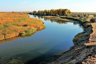
The Ilek is a river in the Aktobe Region, Kazakhstan, and Orenburg Oblast, Russia. It is 149 kilometres (93 mi) long, and has a drainage basin of 13,700 square kilometres (5,300 sq mi).

The Abashevo culture is a late Middle Bronze Age archaeological culture, ca. 2200–1850 BC, found in the valleys of the middle Volga and Kama River north of the Samara bend and into the southern Ural Mountains. It receives its name from the village of Abashevo in Chuvashia.

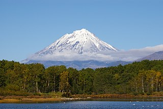
Stepan Petrovich Krasheninnikov was a Russian explorer of Siberia, naturalist and geographer who gave the first full description of Kamchatka in the early 18th century. He was elected to the Russian Academy of Sciences in 1745. The Krasheninnikov Volcano on Kamchatka is named in his honour.
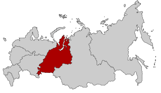
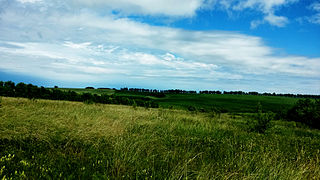
Ural is a geographical region located around the Ural Mountains, between the East European and West Siberian plains. It is considered a part of the Eurasian Steppe, extending approximately from the North to the South; from the Arctic Ocean to the end of the Ural River near Orsk city. The border between Europe and Asia runs along the Eastern side of the Ural Mountains. Ural mostly lies within Russia but also includes a small part of Northwestern Kazakhstan. This is historical, not an official entity, with borders overlapping its Western Volga and Eastern Siberia neighboring regions. At some point in the past, parts of the currently existing Ural region were considered a gateway to Siberia, or even Siberia itself, and were combined with the Volga administrative the divisions. Today, there are two official namesake entities: the Ural Federal District and the Ural economic region. While the latter follows the historical borders, the former is a political product; the District omits Western Ural and includes Western Siberia instead.

The Kazakh Steppe, also known as the Great Steppe or Great Dala, is a vast region of open grassland in Central Asia, covering areas in northern Kazakhstan and adjacent areas of Russia. It lies east of the Pontic–Caspian steppe and west of the Emin Valley steppe, with which it forms the central and western part of the Eurasian steppe. The Kazakh Steppe is an ecoregion of the temperate grasslands, savannas, and shrublands biome in the Palearctic realm. Before the mid-19th century, it was called the Kirghiz steppe, 'Kirghiz' being an old Russian word for the Kazakhs.

Minuartia is a genus of flowering plants commonly known as sandworts in the family Caryophyllaceae.

The Eurasian Steppe, also called the Great Steppe or The Steppes, is the vast steppe ecoregion of Eurasia in the temperate grasslands, savannas and shrublands biome. It stretches through Hungary, Bulgaria, Romania, Moldova, Ukraine, southern Russia, Kazakhstan, Xinjiang, Mongolia and Manchuria, with one major exclave, the Pannonian steppe, located mostly in Hungary.

A forest steppe is a temperate-climate ecotone and habitat type composed of grassland interspersed with areas of woodland or forest.

The steppe pika is a small mammal of the pika family, Ochotonidae. It is found in the steppes of southern Russia and northern Kazakhstan.

The Great Plan for the Transformation of Nature, also known as Stalin's plan for the transformation of nature, was proposed by Joseph Stalin in the Soviet Union in the second half of the 1940s, for land development, agricultural practices and water projects to improve agriculture in the nation. Its propaganda motto and catchphrase was "the great transformation of nature".
The wildlife of Russia inhabits terrain that extends across 12 time zones and from the tundra region in the far north to the Caucasus Mountains and prairies in the south, including temperate forests which cover 70% of the country. Russia's forests comprise 22% of the forest in the world as well as 33% of all temperate forest.

Coleophora squalorella is a moth of the family Coleophoridae. It is found from Fennoscandia to Austria, Croatia, Romania and Ukraine and from the Netherlands to the Baltic states. It is also known from the lower Volga and Ural regions of Russia and China. It occurs in steppe and semi-desert biotopes.

Bashkiriya National Park covers a large contiguous forest on the southern end of the Ural Mountains. The park is an important buffer between the industrialized flatlands to the west, and the mountainous and sparsely populated Shulgan-Tash nature reserve and Altyn-Solok entomological reserve to the east and north. Bashkirya National Park lies between the Nugush River, and the southern bend of the Belaya River. The park features deep river valley cuts in a karst topography. It is known for a natural bridge across the river Kuperlya. The park is situated across three districts of the Republic of Bashkortostan.

Shulgan-Tash Nature Reserve is a Russian 'zapovednik' in the western foothills of the Southern Ural Mountains. The terrain is one of heavy forest and karst topography; the site contains some of the oldest caves of human habitation. The reserve has 13 full-time "bortniks" - practitioners of the ancient apiculture (bee-keeping) of tree-hollow cultivation of wild honeybees. The reserve is situated in the Burzyansky District of Bashkortostan. It is about 40 km southeast of the District town of Starosubkhangulovo. In 2012, the reserve was added to the UNESCO Biosphere Reserve "Bashkir Ural", in particular for protection of the Burzyuan bee, which has been cultivated since ancient times by the local Bashkir people.
Shaytan-Tau Nature Reserve is a Russian 'zapovednik' located along the Shaytantau ridge of the Southern Urals. The ridge contains limestone reefs which are of Cambrian age, almost 500 million years old. The main purpose of the reserve is to conserve representative Dubravnaya steppe and low-lying bog habitats of relict and endemic species of plants and animals. The area is the youngest federal reserve in the Urals, being set aside for protection on October 9, 2014. It is separated into four sectors, situated in both the Kuvandyksky District of Orenburg Oblast, and in Bashkortostan. It is about 220 km from the regional city of Orenburg.

Orenburg Nature Reserve is a Russian 'zapovednik' dedicated to the preservation and restoration of four separate types of steppe landscape: Transvolga, Ural Mountains, Southern Urals and Trans-Urals. The reserve does this by spreading out across four sections across 400 km of steppes in Orenburg Oblast below the southern terminus of the Ural Mountains. The city of Orenburg sits in the middle of the four sectors, approximately 1,200 km southeast of Moscow. The reserve also protects historical and archaeological sites of the Sarmation people from the seventh to third century BCE. The reserve was formally established in 1988, and covers a total area of 21,653 ha (83.60 sq mi).
The East European forest steppe ecoregion is a patchwork of broadleaf forest stands and grasslands (steppe) that stretches 2,100 km across Eastern Europe from the Ural Mountains in Ural, through Povolzhye, Central Russia to the middle of Ukraine. There are isolated areas of similar character off the western end in eastern Romania, Moldova, and Bulgaria.

Zigalga National Park is located on the high Zigalga Ridge of the Southern Ural Mountains in Russia, on the transition between Europe and Siberia. Much of the territory is untouched by human activity and so supports Ice Age relict floral communities through all altitude zones - pine and birch forest, dark coniferous taiga, alpine meadows and mountain tundra. The park was officially created in 2019. The park is located in the Katav-Ivanovsky District of Chelyabinsk Oblast.