Dickinson Theodore Roosevelt Regional Airport, formerly Dickinson Municipal Airport, is six miles south of Dickinson, in Stark County, North Dakota. It is owned by the Dickinson Airport Authority.

Watertown Regional Airport, formerly Watertown Municipal Airport, is two miles northwest of Watertown in Codington County, South Dakota, United States.

Sioux Falls Regional Airport, also known as Joe Foss Field, is a public and military use airport three miles northwest of Sioux Falls, South Dakota, United States. It is named in honor of aviator and Sioux Falls native Joe Foss, who later served as the 20th Governor of South Dakota (1955–1959).

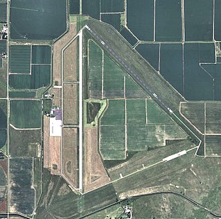
Aberdeen Regional Airport is a city-owned, public-use airport located two nautical miles east of the central business district of Aberdeen, a city in Brown County, South Dakota, United States. It is mostly used for general aviation with Delta Connection as its sole commercial airline.

Sioux Gateway Airport, also known as Brigadier General Bud Day Field, is a public and military use airport in Woodbury County, Iowa, United States. It is located six nautical miles south of the central business district of Sioux City, just west of Sergeant Bluff. On May 25, 2002, the airport was named in honor of United States Air Force Colonel George Everette "Bud" Day, a Sioux City, Iowa, native who is the only person ever awarded both the Medal of Honor and the Air Force Cross.
Airlake Airport is a public use airport in Dakota County, Minnesota, United States. Owned by the Metropolitan Airports Commission, It is approximately 20 miles (32 km) south of both downtown Minneapolis and downtown St. Paul The airport is located near the Twin Cities suburbs of Lakeville and Farmington.
Ainsworth Regional Airport is seven miles northwest of Ainsworth, in Brown County, Nebraska. It is owned by the Ainsworth Airport Authority. The National Plan of Integrated Airport Systems for 2011–2015 called it a general aviation airport.
Harrold Municipal Airport is a city-owned, public-use airport located one nautical mile (1.85 km) northwest of the central business district of Harrold, in Hughes County, South Dakota, United States.
Britton Municipal Airport is a city-owned, public-use airport located two nautical miles northeast of the central business district of Britton, a city in Marshall County, South Dakota, United States. According to the FAA's National Plan of Integrated Airport Systems for 2009–2013, it is categorized as a general aviation airport.
Hot Springs Municipal Airport is a city-owned public-use airport located five nautical miles southeast of the central business district of Hot Springs, a city in Fall River County, South Dakota, United States. According to the FAA's National Plan of Integrated Airport Systems for 2009–2013, it is categorized as a general aviation facility.
Pine Ridge Airport is a public use airport located two nautical miles (3.7 km) east of the central business district of Pine Ridge, in Oglala Lakota County, South Dakota, United States. The airport is owned by the Oglala Sioux Tribe, which has its tribal headquarters at Pine Ridge on the Pine Ridge Indian Reservation. According to the FAA's National Plan of Integrated Airport Systems for 2009–2013, it is categorized as a general aviation facility.
Graham Field is a privately owned public-use airport located one nautical mile north of the central business district of North Sioux City, in Union County, South Dakota, United States.
Madison Municipal Airport is a city-owned public use airport located one nautical mile northeast of the central business district of Madison, a city in Lake County, South Dakota, United States. This airport is included in the FAA's National Plan of Integrated Airport Systems for 2009–2013, which categorized it as a general aviation facility.
Orange City Municipal Airport was a city-owned public-use airport located one nautical mile (1.85 km) south of the central business district of Orange City, a city in Sioux County, Iowa, United States. This airport was included in the FAA's National Plan of Integrated Airport Systems for 2009–2013, which categorized it as a general aviation facility.
Mission Field is a public use airport located five nautical miles east of the central business district of Livingston, a city in Park County, Montana, United States. It is owned by the city and county. This airport is included in the National Plan of Integrated Airport Systems for 2011–2015, which categorized it as a general aviation facility.
Eureka Municipal Airport is a city-owned, public-use airport located two nautical miles (4 km) north of the central business district of Eureka, a city in McPherson County, South Dakota, United States. It is included in the National Plan of Integrated Airport Systems for 2011–2015, which categorized it as a general aviation facility.
McIntosh Municipal Airport was a public use airport located one nautical mile (2 km) south of the central business district of McIntosh, a city in Corson County, South Dakota, United States. The airport property is owned by the City of McIntosh.
Rosebud Sioux Tribal Airport is a public use airport located two nautical miles (4 km) south of the central business district of Rosebud, in Todd County, South Dakota, United States. The airport is owned by the Rosebud Sioux Tribe.
Martin Municipal Airport is a city-owned, public-use airport located one nautical mile (2 km) southeast of the central business district of Martin, a city in Bennett County, South Dakota, United States. It is included in the National Plan of Integrated Airport Systems for 2011–2015, which categorized it as a general aviation facility.
Marv Skie–Lincoln County Airport is a public use airport in Lincoln County, South Dakota, United States. It is owned by Lincoln County and located two nautical miles (4 km) northeast of the central business district of Tea, South Dakota. This airport is included in the National Plan of Integrated Airport Systems for 2011–2015, which categorized it as a general aviation facility.