
Biggs Junction is an unincorporated community in Sherman County, Oregon, United States. For statistical purposes, the United States Census Bureau has defined Biggs Junction as a census-designated place (CDP). The census definition of the area may not precisely correspond to local understanding of the area with the same name.

The Historic Columbia River Highway is an approximately 75-mile-long (121 km) scenic highway in the U.S. state of Oregon between Troutdale and The Dalles, built through the Columbia River Gorge between 1913 and 1922. As the first planned scenic roadway in the United States, it has been recognized in numerous ways, including being listed on the National Register of Historic Places, being designated as a National Historic Landmark by the U.S. Secretary of the Interior, being designated as a National Historic Civil Engineering Landmark by the American Society of Civil Engineers, and being considered a "destination unto itself" as an All-American Road by the U.S. Secretary of Transportation. The historic roadway was bypassed by the present Columbia River Highway No. 2 from the 1930s to the 1950s, leaving behind the old two-lane road. The road is now mostly owned and maintained by the state through the Oregon Department of Transportation as the Historic Columbia River Highway No. 100 or the Oregon Parks and Recreation Department as the Historic Columbia River Highway State Trail.

The Necanicum River is a river on the Pacific coast of northwest Oregon in the United States, approximately 21 miles (34 km) long. It drains a timber-producing area of the Northern Oregon Coast Range northwest of Portland. It forms the first estuary south of the mouth of the Columbia River along the Oregon Coast, reaching the Pacific Ocean at Seaside in Clatsop County.

Rooster Rock State Park is a state park located east of Corbett, in the U.S. state of Oregon. One of the features of the park is Rooster Rock, a column of basalt forming a natural obelisk, which stands near the south side of the Columbia River Gorge, in the lee of Crown Point. The park is administered by the Oregon Parks and Recreation Department.

Shepperd's Dell is a small canyon in the Columbia River Gorge in Oregon, located at 45.54833°N 122.195°W which is less than one-third mile southeast of Rooster Rock State Park. The Shepperd's Dell Bridge is listed on the National Register of Historic Places.

Strawberry Mountain is the highest peak in the Strawberry Mountains of eastern Oregon in the United States. It is the 30th highest point in Oregon. It is in the Malheur National Forest and is the most prominent feature of the Strawberry Mountain Wilderness.

Odell Lake is located near Willamette Pass in the northwest corner of Klamath County, Oregon, United States. It is one of several lakes in the Cascade Range in Central Oregon, and lies within the Deschutes National Forest. It was named for Oregon Surveyor General William Holman Odell by Bynon J. Pengra, in July 1865, while they were making a preliminary survey for the Oregon Central Military Road, which would later become Oregon Route 58. The lake fills a basin carved by a glacier, and the resulting terminal moraine confines the water along the lake's southeast shore.
Dee is an unincorporated community and former company town in Hood River County, Oregon, United States, on Oregon Route 281, about 11 miles south of Hood River.
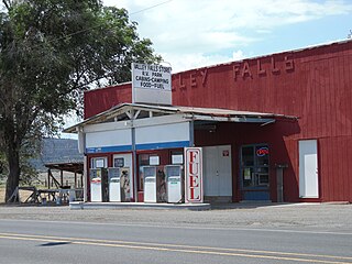
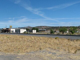
Valley Falls is a small unincorporated community in Lake County, Oregon, United States. The settled area is located at the junction of U.S. Route 395 and Oregon Route 31. The community is named for a small falls on the Chewaucan River just north of the occupied site. East of Valley Falls, the cliff face of Abert Rim overlooks the community.

Bridge Creek is a 28-mile (45 km) tributary of the John Day River in the U.S. state of Oregon. Part of the drainage basin of the Columbia River, its watershed covers 267 square miles (690 km2) in Wheeler County.

Kelley Point Park is a city park in north Portland in the U.S. state of Oregon. Bounded by the Columbia Slough on the south, the Willamette River on the west, and the Columbia River on the north, the park forms the tip of the peninsula at the confluence of the rivers. Marine Terminal 6 of the Port of Portland lies immediately east of the park along the Columbia, while Terminal 5 is along the Willamette slightly south of the Columbia Slough. The park is at 45.6498384°N 122.7637106°W and rises to an elevation of 39 feet (12 m) above sea level. Sauvie Island is west of the park across the Willamette River. Hayden Island is slightly upstream of the park on the Columbia River opposite Marine Terminal 6.
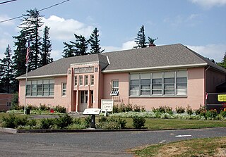
Springdale is an unincorporated community in Multnomah County in the U.S. state of Oregon. Located between Troutdale and Corbett on the Historic Columbia River Highway, it was named for the many springs in the area. In the 1890s, the east end of the community was called Springdale, but the west end was called Gage. Gage had a post office from 1900 to 1903. The Springdale School, also known as the Springdale Community Center, is listed on the National Register of Historic Places and currently houses the CAPS program of the Corbett School District.

Dolph is an unincorporated community in Tillamook County, Oregon, United States, near the Yamhill County line. It lies at the junction of Oregon Route 22 and Oregon Route 130 between Grande Ronde and Hebo, on the Little Nestucca River. It is within the Siuslaw National Forest in the Northern Oregon Coast Range.
Mayger is an unincorporated community in Columbia County, Oregon, United States. Fishing is important to Mayger. It was originally the site of Frenchman Charles Mayger's Mayger Logging Company, which he sold in 1886 to William F. Slaughter. Mayger's post office was established three years later and its first postmaster was Charles Mayger. It closed in 1961. Mayger is served by the Clatskanie, Oregon post office.

Quincy is an unincorporated community in Columbia County, Oregon, United States. It is located about 4.5 miles northeast of Clatskanie and 3.5 miles southwest of Mayger in a drained and diked area of the Columbia River lowlands.
Olene is an unincorporated community in Klamath County, Oregon, United States. It is 10 miles (16 km) southeast of Klamath Falls on Oregon Route 140. Olene currently has a general store and at one time it had a school. In 1940 Olene had a population of 62 and was considered a suburb of Klamath Falls. Olene was the center of a prosperous dairy and potato farming district.
Hampton is an unincorporated community in Deschutes County, Oregon, United States. It lies about 60 miles (97 km) southeast of Bend, on U.S. Route 20, on the edge of the High Desert.

Warrendale is an unincorporated community in Multnomah County, Oregon, United States. It is located about a mile east of Dodson and about 3 miles (4.8 km) west of Bonneville in the Columbia River Gorge on Interstate 84/U.S. Route 30. It is across the Columbia River from Beacon Rock. The community was the site of an important salmon cannery founded in the 1870s.
Blalock was an unincorporated community located in the Columbia River Gorge in Gilliam County, Oregon, United States. The town displaced a Native American settlement originally named Táwash. Blalock was located about 7 miles (11 km) west of Arlington on Interstate 84/U.S. Route 30 at the mouth of Blalock Canyon. Blalock is still the name of a station on the Union Pacific Railroad.

