
The Jungfrau Railway is a mountain rack railway in the Bernese Alps, Switzerland, connecting Kleine Scheidegg in the Bernese Oberland to the Jungfraujoch, across the Valais border. It is the highest railway in Switzerland and Europe, running 9 kilometres (5.6 mi) from the station of Kleine Scheidegg to the Jungfraujoch, well above the perennial snow line. As a consequence, the railway runs essentially within the Jungfrau Tunnel, built into the neighbouring Eiger and Mönch, to protect the line from snow and extreme weather.

The Jungfrau, at 4,158 meters (13,642 ft) is one of the main summits of the Bernese Alps, located between the northern canton of Bern and the southern canton of Valais, halfway between Interlaken and Fiesch. Together with the Eiger and Mönch, the Jungfrau forms a massive wall of mountains overlooking the Bernese Oberland and the Swiss Plateau, one of the most distinctive sights of the Swiss Alps.
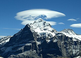
The Wetterhorn is a peak in the Swiss Alps towering above the village of Grindelwald. Formerly known as Hasle Jungfrau, it is one of three summits on a mountain named the "Wetterhörner", the highest of which is the Mittelhorn and the lowest and most distant the Rosenhorn. The latter peaks are mostly hidden from view from Grindelwald.

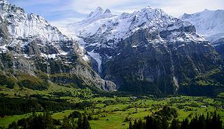
Grindelwald is a village and municipality in the Interlaken-Oberhasli administrative district in the canton of Berne. In addition to the village of Grindelwald, the municipality also includes the settlements of Alpiglen, Burglauenen, Grund, Itramen, Mühlebach, Schwendi, Tschingelberg and Wargistal.

Wetterhorn Peak is a fourteen thousand-foot mountain peak in the U.S. state of Colorado. It is located in the Uncompahgre Wilderness of the northern San Juan Mountains, in northwestern Hinsdale County and southeastern Ouray County, approximately 9 miles (14 km) east of the town of Ouray and 2.75 mi (4.4 km) west of Uncompahgre Peak.

The Grosse Scheidegg is a mountain pass in the Bernese Alps of Switzerland, The pass crosses the col between the Schwarzhorn and the Wetterhorn mountains at an elevation of 1,962 m (6,437 ft).
Grindelwald may refer to:

The Schynige Platte is a small mountain ridge and a viewpoint in the Bernese Highlands and belongs to the Schwarzhorn group. The mountain range consists of three peaks: Gumihorn, Tuba, and the closest summit next to the viewpoint, Geiss. The viewpoint lies at an altitude of about 2,000 metres (7,000 ft), at the western end of a prominent ridge of the Schwarzhorn group, which separates the valley of the Schwarze Lütschine from Lake Brienz.
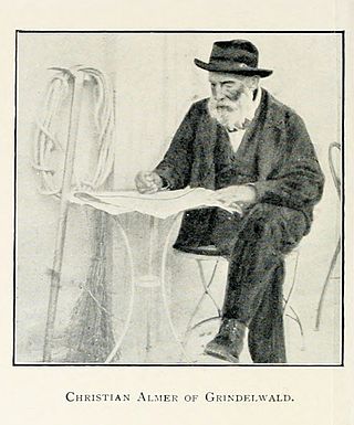
Christian Almer was a Swiss mountain guide and the first ascentionist of many prominent mountains in the western Alps during the golden and silver ages of alpinism. Almer was born and died in Grindelwald, Canton of Bern.
The Upper Grindelwald Glacier is one of the two valley glaciers near Grindelwald on the northern side of the Bernese Alps, in the canton of Bern. It had a length of about 6.6 km (4.1 mi) and covered an area of 9.6 km2 (3.7 sq mi) in 1973.

The Rosenhorn is a peak in the Bernese Alps in the Bernese Oberland. It is lowest of the three composing the Wetterhorner massif, and most distant from the alpine village of Grindelwald to the southwest.
Reichenbachtal is an Alpine valley in Oberhasli, canton of Berne, Switzerland. It is situated within the municipality of Schattenhalb, connecting Meiringen with the Grosse Scheidegg pass towards Grindelwald. Its water, the Rychenbach, forms the Reichenbach Fall before joining the Aare at Meiringen.

Samuel Brawand was a Swiss politician (SP) and mountaineer.
Fritz Steuri was a Swiss mountain climber and Nordic and alpine skier. He was a three-time Swiss champion in cross-country skiing. In 1921, he took part in the first ascent of the Mittellegigrat.
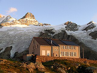
The Gleckstein Hut is a mountain hut of the Swiss Alpine Club, located east of Grindelwald in the canton of Bern. The hut lies at a height of 2,317 metres above sea level, above the Upper Grindelwald Glacier, at the foot of the Wetterhorn in the Bernese Alps.

Stanhope Templeman Speer was a British physician and mountain climber.
Peter Kaufmann was a Swiss mountain guide during the Silver Age of Alpinism (1865-1882) and the early twentieth century, who guided amateurs, experienced climbers, and several notables across glaciers, over mountain passes, and to the summits in the Swiss Alps, the Canadian Rockies, and the Selkirks.

Hans Kaufmann was a Swiss mountain guide who served clients in the Alps, the Rocky Mountains, the Dolomites, the Carpathians, and the Andes.

Peter Bohren was a Swiss mountain guide from Grindelwald.

The Wetterhorn Elevator was an aerial tramway in the valley of Grindelwald. It connected the base of the Upper Grindelwald Glacier to a higher location in the Wetterhorn massif. The tramway was inaugurated in 1908, making it the first of its kind in Switzerland. It closed only a few years later in 1915.

