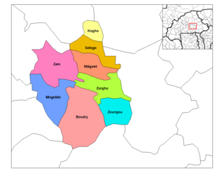
Mogtédo | |
---|---|
Department | |
Mogtédo Department location in the province | |
Country | |
Province | Ganzourgou Province |
Government | |
• Type | Mogtedo has a king who take care of the tradition and make sure that certain moral values don't change with the time. It also has a mayor whose name is Mr. Tibo Joseph Guigma. The mayor take care of the social duties such as birth, lands, weddings, and commerce certificates. He is the one who ensure that the whole department respect the bylaws and signs all the legal documents. |
• Mayor, | Tibo Joseph Guigma. King, Sa Majesty Naba Koabga de Mogtedo. |
Population (2012) | |
• Total | 44,668 |
Time zone | GMT 0 (UTC+0) |
Mogtédo is a department or commune of Ganzourgou Province in central-eastern Burkina Faso. Its capital lies at the town of Mogtédo. According to the 2006 general population census, actualized in 2012 for the municipal elections, the department has a total population of 44,668. [1]
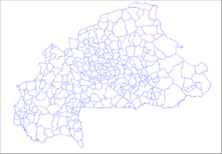
The provinces of Burkina Faso are divided into 351 departments, whose urbanized areas are grouped into the same commune (municipality) with the same name as the department. The 351 communes created in those departments have three kinds of status :
Ganzourgou is a province of Burkina Faso and is in Plateau-Central Region. The capital of Ganzourgou is Zorgho, which is along the road between Ouagadougou and Niamey, Niger. Other important localities in the province are Mogtédo and Méguet. The population of Ganzourgou in 2006 was 319,830.
Burkina Faso is a landlocked country in West Africa. It covers an area of around 274,200 square kilometres (105,900 sq mi) and is surrounded by six countries: Mali to the north; Niger to the east; Benin to the southeast; Togo and Ghana to the south; and Ivory Coast to the southwest. The July 2018 population estimate by the United Nations was 19,751,651. Burkina Faso is a francophone country, with French as the official language of government and business. Roughly 40% of the population speaks the Mossi language. Formerly called the Republic of Upper Volta (1958–1984), the country was renamed "Burkina Faso" on 4 August 1984 by then-President Thomas Sankara. Its citizens are known as Burkinabé. Its capital is Ouagadougou.
Mogtédo, also spelt Mogtedo or Moktedo, is a town located in the province of Ganzourgou in Burkina Faso. The population of Mogtédo is 15,076, and it is the capital of Mogtédo Department.
Bomboré is a town in the Mogtédo Department of Ganzourgou Province in central Burkina Faso. The town has a population of 1,007.
Gadghin is a village in the Mogtédo Department of Ganzourgou Province in central Burkina Faso. The village has a population of 301.
Bana is a department or commune of Balé Province in southern Burkina Faso. Its capital lies at the town of Bana. According to the 1996 census the department has a population of 12,299.
Balavé is a department or commune of Banwa Province in western Burkina Faso. Its capital lies at the town of Balavé. According to the 1996 census the department has a total population of 14,820.
Bagré is a department or commune of Boulgou Province in eastern Burkina Faso. Its capital lies at the town of Bagré. According to the 2006 census, actualized for the municipal élections of 2013, the department has a total population of 29,164.
Bané is a department or commune of Boulgou Province in eastern Burkina Faso. Its capital lies at the town of Bané. According to the 1996 census the department has a total population of 22,923.
Bissiga is a department or commune of Boulgou Province in eastern Burkina Faso. Its capital lies at the town of Bissiga. According to the 1996 census the department has a total population of 19,264.
Bittou is a department or commune of Boulgou Province in eastern Burkina Faso. Its capital lies at the town of Bittou. According to the 1996 census the department has a total population of 34,496.
Garango is a department or commune of Boulgou Province in eastern Burkina Faso. Its capital lies at the town of Garango. According to the 1996 census the department has a total population of 67,737.
Komtoèga is a department or commune of Boulgou Province in eastern Burkina Faso. Its capital lies at the town of Komtoèga. According to the 1996 census the department has a total population of 18,917.
Niaogho is a department or commune of Boulgou Province in eastern Burkina Faso. Its capital lies at the town of Niaogho. According to the 1996 census the department has a total population of 25,702.
Zoaga is a department or commune of Boulgou Province in eastern Burkina Faso. Its capital lies at the town of Zoaga. According to the 1996 census the department has a total population of 11,295.
Zonsé is a department or commune of Boulgou Province in eastern Burkina Faso. Its capital lies at the town of Zonsé. According to the 1996 census the department has a total population of 19,916.
Kogho is a department or commune of Ganzourgou Province in central-eastern Burkina Faso. Its capital lies at the town of Kogho. According to the 1996 census the department has a total population of 15,524.
Méguet is a department or commune of Ganzourgou Province in central-eastern Burkina Faso. Its capital lies at the town of Méguet. According to the 1996 census the department has a total population of 34,668.
Zam is a department or commune of Ganzourgou Province in central-eastern Burkina Faso. Its capital lies at the town of Zam. According to the 1996 census the department has a total population of 39,259.
Zorgho is a department or commune of Ganzourgou Province in central-eastern Burkina Faso. Its capital lies at the town of Zorgho. According to the 1996 census the department has a total population of 49,648.
Zoungou is a department or commune of Ganzourgou Province in central-eastern Burkina Faso. Its capital lies at the town of Zoungou. According to the 1996 census the department has a total population of 29,753.
Nobsin is a town in the Mogtédo Department of Ganzourgou Province in central Burkina Faso. The town has a population of 1,998.
Salogo is a department or commune of Ganzourgou Province in central-eastern Burkina Faso. Its capital lies at the town of Salogo. According to the 2006 census, the department has a total population of 21,405.
Uthanur or Uttanur is a village located in Mulbagal Tehsil of Kolar district in the southern Indian state of Karnataka. It is located about 85 km east of the state capital, Bangalore. In 2011, its population was 1604 inhabitants, with 817 males and 787 females.
Coordinates: 12°17′04″N0°50′14″W / 12.28444°N 0.83722°W
A geographic coordinate system is a coordinate system that enables every location on Earth to be specified by a set of numbers, letters or symbols. The coordinates are often chosen such that one of the numbers represents a vertical position and two or three of the numbers represent a horizontal position; alternatively, a geographic position may be expressed in a combined three-dimensional Cartesian vector. A common choice of coordinates is latitude, longitude and elevation. To specify a location on a plane requires a map projection.
This Ganzourgou Province location article is a stub. You can help Wikipedia by expanding it. |