Zoétgomdé, Ganzourgou

Last updated
Zoétgomdé
CountryFlag of Burkina Faso.svg  Burkina Faso
Region Plateau-Central Region
Province Ganzourgou
Department Salogo Department
Population (2005 est.)
  Total 186

Zoétgomdé is a village in the Salogo Department of Ganzourgou Province in central Burkina Faso. The village has a population of 186. [1]

Salogo Department Department in Plateau-Central Region, Burkina Faso

Salogo is a department or commune of Ganzourgou Province in central-eastern Burkina Faso. Its capital lies at the town of Salogo. According to the 2006 census, the department has a total population of 21,405.

Ganzourgou Province Province in Plateau-Central Region, Burkina Faso

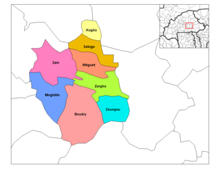
Ganzourgou is a province of Burkina Faso and is in Plateau-Central Region. The capital of Ganzourgou is Zorgho, which is along the road between Ouagadougou and Niamey, Niger. Other important localities in the province are Mogtédo and Méguet. The population of Ganzourgou in 2006 was 319,830.

Burkina Faso country in Africa

Burkina Faso is a landlocked country in West Africa. It covers an area of around 274,200 square kilometres (105,900 sq mi) and is surrounded by six countries: Mali to the north; Niger to the east; Benin to the southeast; Togo and Ghana to the south; and Ivory Coast to the southwest. The July 2018 population estimate by the United Nations was 19,751,651. Burkina Faso is a francophone country, with French as the official language of government and business. Roughly 40% of the population speaks the Mossi language. Formerly called the Republic of Upper Volta (1958–1984), the country was renamed "Burkina Faso" on 4 August 1984 by then-President Thomas Sankara. Its citizens are known as Burkinabé. Its capital is Ouagadougou.

Related Research Articles

Geography of France

The geography of France consists of a terrain that is mostly flat plains or gently rolling hills in the north and west and mountainous in the south and the east.

Ștefăneștii de Jos Commune in Ilfov County, Romania

Ștefăneștii de Jos is a commune in the centre of Ilfov County, Romania. Its name means "Lower Ștefănești", derived from Ștefan (Stephan) and suffix -ești. The commune is composed of three villages: Crețuleasca, Ștefăneștii de Jos and Ștefăneștii de Sus.

Grenadines Parish Parish in Port Elizabeth, Saint Vincent and the Grenadines

Grenadines is an administrative parish of Saint Vincent and the Grenadines. Its capital is Port Elizabeth.

Muľa municipality of Slovakia

Muľa is a village and municipality in the Veľký Krtíš District of the Banská Bystrica Region of southern Slovakia.

Veľké Borové municipality of Slovakia

Veľké Borové is a village and municipality in Liptovský Mikuláš District in the Žilina Region of northern Slovakia.

Beregdaróc Place in Szabolcs-Szatmár-Bereg, Hungary

Beregdaróc is a village in Szabolcs-Szatmár-Bereg county, in the Northern Great Plain region of eastern Hungary.

Casas del Puerto de Villatoro Place in Castile and León, Spain

Casas del Puerto de Villatoro is a municipality located in the province of Ávila, Castile and León, Spain. According to the 2005 census (INE), the municipality has a population of 108 inhabitants.

San Cebrián de Campos is a municipality located in the province of Palencia, Castile and León, Spain. According to the 2004 census (INE), the municipality has a population of 471 inhabitants.

Fuentenebro is a municipality located in the province of Burgos, Castile and León, Spain. According to the 2015 census (INE), the municipality has a population of 139 inhabitants.

Gêla is a village and township in the Tibet Autonomous Region of China.

Sissin is a village in the Zimtenga Department of Bam Province in northern-central Burkina Faso. It has a population of 195.

Qasımbəyli, Agsu Place in Agsu, Azerbaijan

Qasımbeyli is a village in the Agsu Rayon of Azerbaijan. The village forms part of the municipality of Ərəbmehdibəy.

Stróże Wielkie Village in Subcarpathian, Poland

Stróże Wielkie is a village in the administrative district of Gmina Sanok, within Sanok County, Subcarpathian Voivodeship, in south-eastern Poland. It lies approximately 3 kilometres (2 mi) south-west of Sanok and 58 km (36 mi) south of the regional capital Rzeszów.

Arynów Village in Masovian, Poland

Arynów is a village in the administrative district of Gmina Mińsk Mazowiecki, within Mińsk County, Masovian Voivodeship, in east-central Poland. It lies approximately 3 kilometres (2 mi) north-west of Mińsk Mazowiecki and 37 km (23 mi) east of Warsaw.

Vicente Guerrero is a municipality in the Mexican state of Puebla. The capital of the commune is Santa María del Monte.

Kenézlő is a village in Borsod-Abaúj-Zemplén County in northeastern Hungary.

Kuremäe Village in Ida-Viru County, Estonia

Kuremäe is a village in Alutaguse Parish, Ida-Viru County in northeastern Estonia.

Tiigi is a village in Haljala Parish, Lääne-Viru County, in northeastern Estonia.

Naudīte is a village in Naudīte Parish and Dobele Municipality in the historical region of Zemgale, and the Zemgale Planning Region in Latvia.

Kafr Mu is a Syrian village located in Harem Nahiyah in Harem District, Idlib. According to the Syria Central Bureau of Statistics (CBS), Kafr Mu had a population of 62 in the 2004 census.

References

Coordinates: 12°32′N2°12′W / 12.533°N 2.200°W / 12.533; -2.200

Geographic coordinate system Coordinate system

A geographic coordinate system is a coordinate system that enables every location on Earth to be specified by a set of numbers, letters or symbols. The coordinates are often chosen such that one of the numbers represents a vertical position and two or three of the numbers represent a horizontal position; alternatively, a geographic position may be expressed in a combined three-dimensional Cartesian vector. A common choice of coordinates is latitude, longitude and elevation. To specify a location on a plane requires a map projection.