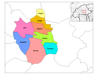
Soea is a khum (commune) of Mongkol Borei District in Banteay Meanchey Province in western Cambodia.

Noșlac is a commune located in Alba County, Romania. It is composed of six villages: Căptălan (Maroskáptalan), Copand (Maroskoppánd), Găbud (Gábod), Noșlac, Stâna de Mureș (Maroscsúcs) and Valea Ciuciului (Zilahipatak).
Milpo is a village in the Iolonioro Department of Bougouriba Province in south-western Burkina Faso. The village has a population of 298.

Dagâța is a commune in Iași County, Romania. It is composed of eight villages: Bălușești, Boatca, Buzdug, Dagâța, Mănăstirea, Piscu Rusului, Poienile, Tarnița and Zece Prăjini. The commune had 4809 people at the 2002 census; of these, 89.8% were ethnic Romanian and 10.2% were Roma. 98.9% of inhabitants were Romanian Orthodox.
Corlățel is a commune located in Mehedinți County, Romania. It is composed of two villages, Corlățel and Valea Anilor.

Pogwizdów is a village in the administrative district of Gmina Bochnia, within Bochnia County, Lesser Poland Voivodeship, in southern Poland. It lies approximately 7 kilometres (4 mi) south-west of Bochnia and 36 km (22 mi) south-east of the regional capital Kraków.

Gorzejowa is a village in the administrative district of Gmina Brzostek, within Dębica County, Subcarpathian Voivodeship, in south-eastern Poland. It lies approximately 13 kilometres (8 mi) south of Dębica and 45 km (28 mi) west of the regional capital Rzeszów.
Szklarka Trzcielska is a village in the administrative district of Gmina Miedzichowo, within Nowy Tomyśl County, Greater Poland Voivodeship, in west-central Poland. It lies approximately 17 kilometres (11 mi) north-west of Nowy Tomyśl and 67 km (42 mi) west of the regional capital Poznań.
Polanowo is a village in the administrative district of Gmina Powidz, within Słupca County, Greater Poland Voivodeship, in west-central Poland. It lies approximately 4 kilometres (2 mi) south of Powidz, 12 km (7 mi) north of Słupca, and 70 km (43 mi) east of the regional capital Poznań.
Miłaczew is a village in the administrative district of Gmina Malanów, within Turek County, Greater Poland Voivodeship, in west-central Poland. It lies approximately 3 kilometres (2 mi) south of Malanów, 12 km (7 mi) south-west of Turek, and 114 km (71 mi) south-east of the regional capital Poznań.

Miłaczew Kolonia is a village in the administrative district of Gmina Malanów, within Turek County, Greater Poland Voivodeship, in west-central Poland. It lies approximately 3 kilometres (2 mi) south of Malanów, 12 km (7 mi) south-west of Turek, and 114 km (71 mi) south-east of the regional capital Poznań.
Warpuny is a village in the administrative district of Gmina Sorkwity, within Mrągowo County, Warmian-Masurian Voivodeship, in northern Poland. It lies approximately 11 kilometres (7 mi) north of Sorkwity, 11 km (7 mi) north-west of Mrągowo, and 48 km (30 mi) east of the regional capital Olsztyn.
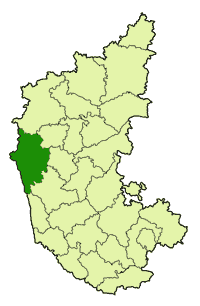
Aigod is a village in the state of Karnataka, India. It is located in the Siddapur taluk of Uttara Kannada district in Karnataka.
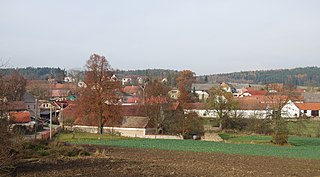
Hlubyně is a village and municipality in Příbram District in the Central Bohemian Region of the Czech Republic.

Hudčice is a village and municipality in Příbram District in the Central Bohemian Region of the Czech Republic.
Sabon-Guida is a village and rural commune in Niger.
Dragomani is a village in Gabrovo Municipality, in Gabrovo Province, in northern central Bulgaria.
Kmetcheta is a village in Gabrovo Municipality, in Gabrovo Province, in northern central Bulgaria.
Popovtsi is a village in Gabrovo Municipality, in Gabrovo Province, in northern central Bulgaria.
Tyumen is the name of several inhabited localities in Russia.