
Belize is a country on the north-eastern coast of Central America. It is bordered by Mexico to the north, the Caribbean Sea to the east, and Guatemala to the west and south. It also shares a water boundary with Honduras to the southeast. It has an area of 22,970 square kilometres (8,867 sq mi) and a population of 441,471 (2022). Its mainland is about 290 km (180 mi) long and 110 km (68 mi) wide. It is the least populated and least densely populated country in Central America. Its population growth rate of 1.87% per year is the second-highest in the region and one of the highest in the Western Hemisphere. Its capital is Belmopan, and its largest city is the namesake city of Belize City. Belize is often thought of as a Caribbean country in Central America because it has a history similar to that of English-speaking Caribbean nations. Belize's institutions and official language reflect its history as a British colony.

Punta Gorda, known locally as P.G., is the capital and largest town of Toledo District in southern Belize. Punta Gorda is the southernmost sizable town in the nation, with a population of about 5,000 people. Although the town bears a Spanish name, its inhabitants are mostly Kriol/English-speaking and are primarily of Garifuna, East Indian, Kriol, and Maya descent.

Stann Creek District is a district in the south east region of Belize. According to the 2010 census, the district had a population of 32,166 people. Its capital is the town of Dangriga, formerly known as "Stann Creek Town." Stann comes from "stanns," or safe havens used by colonialists coming from the "old world" to the "new world."

Toledo District is the southernmost and least populated district in Belize. Punta Gorda is the District capital. According to the Human Development Index (HDI), it is the second most developed region in the country. The district has a diverse topography which features rainforests, extensive cave networks, coastal lowland plains, and offshore cays. Toledo is home to a wide range of cultures such as Mopan, Kekchi Maya, Creole, Garifuna, East Indians, Mennonites, Mestizos, and descendants of US Confederate settlers.
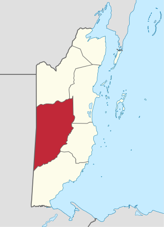
Cayo District is a district located in the west part of Belize. It is the most extensive, second-most populous and third-most densely populated of the six districts of Belize. The district's capital is the town of San Ignacio.

Nim Li Punit is a Maya Classic Period site in the Toledo District of the nation of Belize, located 50 kilometres north of the town of Punta Gorda, and directly adjacent to the village of Indian Creek. Nim Li Punit is sometimes known as Big Hat or Top Hat; the name is Kekchi Maya for "Big Hat", referring to the large elaborate head-dress on a stela sculpture found on site depicting one of the site's ancient kings. It is bordered by the Maya Mountains to the west and lowland swamps and the Caribbean Sea to the east.
Mullins River is the name of both a river and of a village on that river in the Stann Creek District of Belize.

Placencia is a small village located in the Stann Creek District of Belize.

Gales Point is a village in Belize District in the nation of Belize, Central America. The village is on a peninsula in the Southern Lagoon In 2000, Gales Point had a population of about 500 people, most of whom subsist on fishing and farming.

Hurricane Iris was a small, but powerful Category 4 hurricane that caused widespread destruction in Belize. Iris was the second-strongest storm of the 2001 Atlantic hurricane season, behind Hurricane Michelle. It was the ninth named storm, fifth hurricane, and third major hurricane of the year, forming from a tropical wave on October 4 just southeast of Barbados. It moved westward through the Caribbean, intensifying into a tropical storm on October 5 south of Puerto Rico, and into a hurricane on the following day. While passing south of the Dominican Republic, Iris dropped heavy rainfall that caused landslides, killing eight people. Later, the hurricane passed south of Jamaica, where it destroyed two houses. On reaching the western Caribbean Sea, Iris rapidly intensified into a Category 4 on the Saffir–Simpson scale. A small hurricane with an eye of only 7 mi (11 km) in diameter, Iris reached peak winds of 145 mph (233 km/h) before making landfall in southern Belize near Monkey River Town on October 9. The hurricane quickly dissipated over Central America, although its remnants contributed to the formation of Tropical Storm Manuel in the eastern Pacific Ocean. The hurricane caused severe damage—destroying homes, flooding streets, and leveling trees—in coastal towns south of Belize City.

Caye Caulker is a small limestone coral island off the coast of Belize in the Caribbean Sea measuring about 5 miles (8.0 km) by less than 1 mile (1.6 km). The town on the island is known by the name Caye Caulker Village. The population of Caye Caulker is approximately 2,000 people today and still growing.

Hopkins Village is a coastal village in eastern Belize.

Monkey River is a coastal watercourse in southern Belize that rises in the Maya Mountains and discharges to the Caribbean Sea near Monkey River Town. One of Belize's major rivers, Monkey River has northern headwaters which originate in the Cockscomb Basin Wildlife Sanctuary, where the Swasey Branch drains the East Basin of that wildlife sanctuary. Further south, the Bladen Branch watercourse drains the eastern slopes of the Maya Mountains including the ancient Mayan settlement areas of Lubaantun and Nim Li Punit. These two watercourses join to form the Monkey River approximately 16 kilometres upstream from the mouth of the Monkey River. The Monkey River is readily navigated throughout the year using small boats, but navigation above the major confluence becomes more difficult due to lack of depth when the dry season starts about February. Habitats in this watershed provide cover for such diverse species as the ocelot, jaguar, Guatemalan black howler, bare-throated tiger heron, Morelet's crocodile, fer-de-lance and manatee.

Payne's Creek National Park is a nature reserve in the Toledo District of southern Belize. The park encompasses 37,680 acres (152 km2) of land including the dominant broadleaf forest as well as mangrove areas.
Water resources management in Belize is carried out by the Water and Sewerage Authority (WASA) in most cases. One of the primary challenges the country is facing with regard to water resources management, however, is the lack of coordinated and comprehensive policies and institutions. Furthermore, there are various areas of water management that are not well addressed at all such as groundwater data and provision of supply. Data on irrigation and drainage is not adequately available either. Demand on water resources is growing as the population increases, new economic opportunities are created, and the agriculture sector expands. This increased demand is placing new threats on the quality and quantity of freshwater resources. Other constant challenge for management entities are the constant threat of floods from tropical storms and hurricanes. The Belize National Emergency Management Organization (NEMO) is charged with flood management as they occur but it is unclear what institution has responsibility for stormwater infrastructures.
Burrell Boom is on the Belize River twenty miles above Belize City, Belize. Tourists pass through this historic village on their way to the Community Baboon Sanctuary, where the population of black howler monkeys has grown to over 2,000.
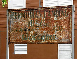
Bermudian Landing is a village in the nation of Belize, located near Scotland Halfmoon in Belize District. The name comes from the Bermuda grass planted by the early loggers to feed their oxen, who were used to drag the mahogany to the landing.

Blue Creek is a village in the Toledo District of Belize. It is a Mopan people and Kekchi village of about 270 people. The community lies along flat roads, spanning both sides of Blue Creek. Clusters of thatch huts border both sides of Blue Creek, a beautiful, clear stream emerging from the surrounding thick jungle. The colour of blue-green pool where Maya women beat their laundry on the smooth stones gave the village its name. The banks are lined with tall shady trees. The reflection of the thick jungle rainforest, which lines both sides, is clearly visible in the surface of the creek.
Community Baboon Sanctuary is a protected area in Belize. It was established in 1985 to help address the threats of agriculture, logging and hunting of the black howler monkey ('baboon') and to educate locals and visitors about the importance of biodiversity, sustainability, and to promote the economic development of the Bermudian Landing community.

Belize, formerly known as British Honduras, is a Caribbean country located on the northeastern coast of Central America. Belize is bordered on the northwest by Mexico, on the east by the Caribbean Sea, and on the south and west by Guatemala. It has an area of 22,970 square kilometres (8,867 sq mi) and a population of 408,487 (2019). Its mainland is about 290 km (180 mi) long and 110 km (68 mi) wide. It has the lowest population and population density in Central America.

