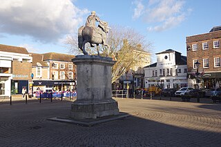
East Hampshire is a local government district in Hampshire, England. Its council is based in the town of Petersfield, although the largest town is Alton. The district also contains the town of Bordon along with many villages and surrounding rural areas.

Ropley is a village and large civil parish in the East Hampshire district of Hampshire, England. It has an acreage of 4,684 acres (1,896 ha), situated 4 miles (6.4 km) east of New Alresford. It is served by a station on the Mid Hants Railway heritage line at Ropley Dean, just over 1 mile (1.6 km) from the village shops. It is 6.7 miles (10.8 km) southwest of Alton, just off the A31 road. It lies within the diocese of Winchester.

Four Marks is a village and civil parish in the East Hampshire district of Hampshire, England. It is 4.4 miles (7.1 km) southwest of Alton, on the A31 road. It is situated on the borders of the South Downs National Park on the Pilgrims' Way that leads from Winchester to Canterbury. It contains within it the medieval hamlets of Kitwood, Hawthorn and Lymington, although now the whole parish is relatively closely settled.

Newton Valence is a village and civil parish in the East Hampshire district of Hampshire, England. It is 4.4 miles (7.1 km) south of Alton, just off the A32 road.

East Hampshire is a constituency represented in the House of Commons of the UK Parliament since 2010 by Damian Hinds of the Conservative Party.

West Meon is a village and civil parish in Hampshire, England, with a population of 749 people at the 2011 census.

Farringdon is a civil parish in the East Hampshire district of Hampshire, England. It is 2.8 miles (4.5 km) south of Alton, on the A32 road, close to a source of the River Wey.
West Tisted is a small village in the East Hampshire district of Hampshire, England. It is 6.7 miles (10.8 km) northwest of Petersfield, just off the A32 road.

East Tisted is a village and civil parish in the East Hampshire district of Hampshire, England. It is 4.8 miles (7.7 km) south of Alton on the A32 road.

Steep is a village and civil parish in the East Hampshire district of Hampshire, England. Its nearest town is Petersfield, which lies 1.4 miles (2.3 km) south of the village, just off the A3 road. The nearest railway station is Petersfield, at 1.6 miles (2.6 km) south of the village. It has two public houses, The Harrow and the Cricketers Inn, with the former being an 18th-century Grade II listed building. According to the 2011 census, it had a population of 1,391.

Limésy is a commune in the Seine-Maritime department in the Normandy region in northern France.

Medstead is a village and civil parish in the East Hampshire district of Hampshire, England. Its nearest town is Alton, which lies 4.3 miles (6.9 km) northeast of the village. According to the 2011 census, the village had a population of 2,036 people. The parish covers an area of 1,536 acres (622 ha) and has an average elevation of approximately 600 feet (180 m) above sea level. One of the county's high points at 716 feet (218 m), King's Hill, runs through Medstead and Bentworth.

Priors Dean is a hamlet in the civil parish of Colemore and Priors Dean, in the East Hampshire district, in the county of Hampshire, England. It is in the Hampshire Downs about 3 miles (5 km) west of Liss and about 4 miles (6.4 km) north of Petersfield. It is a deserted medieval village first mentioned in the 1100s. Until 1932 it was a separate parish. The nearest railway station is at Liss.

Ropley Dean also Dene or simply The Dean / Dene is a hamlet in the parish of Ropley, Hampshire, England. It is 7.3 miles (11.7 km) southwest of Alton.
West Worldham is a small village and former civil parish, now in the parish of Worldham, in the East Hampshire district of Hampshire, England. It is 2.1 miles (3.4 km) southeast of the town of Alton. The village of East Worldham is to the East and Hartley Mauditt is to the South, which along with West Worldham form the current Parish of Worldham.

Kitwood is a hamlet in the parish of Four Marks, Hampshire, England. It is in the south east of the Parish and has been part of Four Marks since its creation in 1932. Prior to this, it was part of Ropley Parish.

North Street is a hamlet in the parish of Ropley in Hampshire, England. The hamlet lies on the A31 road from Alton to Winchester.

Charlwood is a small hamlet in the East Hampshire district of Hampshire, England. It is in the large civil parish of Ropley and partially in East Tisted.


