
Lasham is a village and civil parish in the East Hampshire district of Hampshire, England. It is 3.4 miles (5.5 km) northwest of Alton and 1.2 miles (1.9 km) north of Bentworth, just off the A339 road. The parish covers an area of 1,797 acres (727 ha) and has an average elevation of 560 feet (170 m) above sea level. The nearest railway station is Alton, 3.5 miles (5.6 km) southeast of the village. Lasham formerly had its own railway station, Bentworth and Lasham, on the Basingstoke and Alton Light Railway until the line's closure in 1936. According to the 2011 census, the village had a population of 176.

Beech is a village and civil parish in the East Hampshire district of Hampshire, England. It lies 2 miles (3 km) west of Alton, just west of the A339 road.

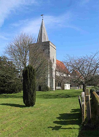
Bentworth is a village and civil parish in the East Hampshire district of Hampshire, England. The nearest town is Alton, which lies about 3 miles (5 km) east of the village. It sits within the East Hampshire Hangers, an area of rolling valleys and high downland. The parish covers an area of 3,763 acres (15.23 km2) and at its highest point is the prominent King's Hill, 716 feet (218 m) above sea level. According to the 2011 census, Bentworth had a population of 553.
Binsted is a village and large civil parish in East Hampshire, England. It is about 4.1 miles (6.6 km) east of Alton, its nearest town. The parish is one of the largest in northern Hampshire and covers almost 7,000 acres (2,800 ha). It contains two villages, Bucks Horn Oak and Holt Pound, as well as two hamlets, Wyck and Wheatley. The parish also covers the entirety of the Alice Holt Forest, a royal forest situated near the border with Surrey. The nearest railway station is 1.8 miles (2.9 km) northeast of the village, at Bentley. According to the 2011 census, the parish had a population of 1,817 people.

Oakhanger is a village in the East Hampshire district of Hampshire, England. Its nearest town is Bordon, 1.7 miles (2.7 km) eastward on the B3004 road. It is part of the parish of Selborne, which covers an area of 7,915 acres (3,203 ha). The nearest railway station is Alton, 3.8 miles (6.1 km) to the northwest; the village had its own Oakhanger Halt railway station on the Longmoor Military Railway until its closure.

Shalden is a village and civil parish in the East Hampshire district of Hampshire, England. It is 2.3 miles (3.7 km) northwest of Alton and 1.9 miles (3.1 km) northeast of Bentworth, just off the A339 road. The parish covers an area of 1,536 acres (622 ha) and has an average elevation of 600 feet (180 m) above sea level. The nearest railway station is Alton, 2.5 miles (4.0 km) southeast of the village. According to the 2011 census, it had a population of 435.

Medstead is a village and civil parish in the East Hampshire district of Hampshire, England. Its nearest town is Alton, which lies 4.3 miles (6.9 km) northeast of the village. According to the 2011 census, the village had a population of 2,036 people. The parish covers an area of 1,536 acres (622 ha) and has an average elevation of approximately 600 feet (180 m) above sea level. One of the county's high points at 716 feet (218 m), King's Hill, runs through Medstead and Bentworth.
Lower Wield is a village in the East Hampshire district of Hampshire, England. It is in the civil parish of Wield. It is 1.8 miles (2.9 km) west of the village of Bentworth, 5.2 miles (8.4 km) west of Alton. The nearest railway station is Alton, 5.2 miles (8.4 km) east of the village.

Winslade is a hamlet and civil parish in the Basingstoke and Deane district of Hampshire, England. It lies 3 miles (4.8 km) south of Basingstoke, just off the A339 road. The hamlet covers an area of 712 acres (288 ha) and has an average elevation of 550 feet (170 m). Its nearest railway station is Basingstoke, 4.2 miles (6.8 km) north of the hamlet. The parish of Winslade contains the vast Hackwood Park, an 89-acre (36 ha) Grade I listed Royal deer park. According to the 2011 census, Winslade, along with Tunworth, Weston Corbett and Weston Patrick, had a population of 224.
Bradley is a small village and civil parish in the Basingstoke and Deane district of Hampshire, England. Its nearest town is Alton, which lies 5.4 miles (8.7 km) southeast from the village, although Basingstoke lies 6.6 miles (10.6 km) to the north. According to the 2011 census, the village had a population of 202 people. The parish covers an area of 975 acres (395 ha), of which 149 acres (60 ha) is woodland and its highest point is 170 metres (560 ft) above sea level. It contains no hamlets.

Southrope is a hamlet in the civil parish of Herriard, Hampshire. It has one pub, named the Fur and Feathers. The hamlet was once considered a part of the civil parish Bentworth, until the late 19th century. Its nearest town is Alton, which lies approximately 5.8 miles (9.3 km) south-east from the hamlet. The hamlet's toponym derives from Old English Sūþrop, meaning south village.
Burkham is a hamlet in the large civil parish of Bentworth in Hampshire, England including a large country house, Burkham House. The nearest town is Alton, which lies about 4.5 miles (7.2 km) to the south-east. Its nearest railway station was formerly the Bentworth and Lasham railway station on the Basingstoke and Alton Light Railway, until its closure in 1932. The nearest railway station is now 3.6 miles (5.8 km) east of the village, at Alton.

Thedden is a hamlet in the large civil parish of Bentworth in Hampshire, England, about 1.3 miles (2.1 km) south east of the centre of Bentworth village. Its nearest town is Alton, about 3.5 miles (5.1 km) east of Thedden.
Ashley is a hamlet in the large civil parish of Bentworth in the East Hampshire district of Hampshire, England. Its nearest town is Alton, which lies approximately 4.3 miles (6.9 km) to the east.
Holt End is a hamlet in the large civil parish of Bentworth in Hampshire, England, between Bentworth and Medstead. The nearest town is Alton, which lies approximately 4 miles (6.4 km) north-east from the hamlet.
Hattingley is a small hamlet in the East Hampshire district of Hampshire, England.

Tickley is a small hamlet in the large civil parish of Bentworth in Hampshire, England. It is considered a part of neighbouring Burkham which is situated 1.2 miles (1.9 km) away; however, it is an individual settlement.
New Copse is a hamlet in the large civil parish of Bentworth in Hampshire, England. The nearest town is Alton, which lies approximately 3.7 miles (6.0 km) to the northeast. The hamlet is often confused with neighbouring Holt End, which also lies in Bentworth.
Wivelrod Manor is a country manor situated in the hamlet of Wivelrod in the parish of Bentworth, Hampshire. It is about 2.5 miles (4.0 km) south of the centre of Bentworth and about 3.2 miles (5.1 km) southeast of Alton, its nearest town. The manor neighbours the nearby Alton Abbey.
Gaston Grange is a large country manor situated in the hamlet of Holt End in the large parish of Bentworth, Hampshire. It is about 1.1 miles (1.8 km) southwest of the centre of Bentworth and about 4.1 miles (6.6 km) west of Alton, its nearest town. The manor lies west of the Bentworth-Medstead road towards Upper Wield, south of Gaston Wood.


