
Hampshire County Council (HCC) is the upper-tier local authority for the non-metropolitan county of Hampshire in England. The council was created in 1889. The county council provides county-level services to eleven of the thirteen districts geographically located within the ceremonial county of Hampshire. The county council acts as the upper tier of local government to approximately 1.4 million people. It is one of 21 county councils in England.
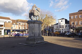
East Hampshire is a local government district in Hampshire, England. Its council is based in the town of Petersfield, although the largest town is Alton. The district also contains the town of Bordon along with many villages and surrounding rural areas.

Bordon is a town in the East Hampshire district of Hampshire, England. It lies in the interior of the royal Woolmer Forest, about 5 miles (8.0 km) southeast of Alton. The town forms a part of the civil parish of Whitehill which is one of two contiguous villages, the other being Lindford. The civil parish is on the A325, and near the A3 road between London and Portsmouth, from which it is buffered by the rise of the wooded Woolmer Ranges. Bordon is twinned with Condé-sur-Vire in Normandy, France.

North East Hampshire is a constituency represented in the House of Commons of the UK Parliament by Alex Brewer, a Liberal Democrat.

The Longmoor Military Railway (LMR) was a British military railway in Hampshire that was built by the Royal Engineers from 1903 to train soldiers on railway construction and operations. The railway ceased operation on 31 October 1969.

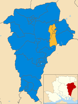
East Hampshire is a constituency represented in the House of Commons of the UK Parliament since 2010 by Damian Hinds of the Conservative Party.

Bordon Camp was a British Army camp close to the settlement of Bordon in Hampshire, England. The camp, which was latterly maintained by the Defence Infrastructure Organisation, opened in 1863 and closed in 2015.
The Bordon Light Railway was a short-lived light railway line in Hampshire that connected the Army Camp at Bordon, as well as the villages of Bordon and Kingsley, with the national rail network at Bentley on the main Farnham-Alton line, a distance of 4.5 miles (7.2 km).

Oakhanger is a village in the East Hampshire district of Hampshire, England. Its nearest town is Bordon, 1.7 miles (2.7 km) eastward on the B3004 road. It is part of the parish of Selborne, which covers an area of 7,915 acres (3,203 ha). The nearest railway station is Alton, 3.8 miles (6.1 km) to the northwest; the village had its own Oakhanger Halt railway station on the Longmoor Military Railway until its closure.

Blackmoor is a village in the East Hampshire district of Hampshire, England. It lies about 1.5 miles (2.5 km) southwest of Bordon, just west of the A325 road.

Whitehill is a village and civil parish in the East Hampshire district of Hampshire, England, on the historic route between Petersfield and Farnham. It is 0.7 miles (1.1 km) south of Bordon and covers an area of approximately 8 square miles.
Hollywater is a small village in Hampshire, England. It lies two miles east to its nearest town, Bordon. The village is a crossing point to Whitehill to Liphook, and has the River Wey running through the village. The village itself is situated in the Woolmer Forest and has one Primary School.
Barford is a scattered hamlet in the civil parish of Headley in the East Hampshire district of Hampshire, England. The village lies on the Hampshire-Surrey border, approximately 2 miles (3.2 km) from Hindhead. Its nearest town is Bordon, which lies approximately 3.6 miles (5.8 km) south-west from the village.
Hogmoor Inclosure is a large area of wooded heath situated 0.5 miles (0.80 km) west from the town of Bordon and within the civil parish of Whitehill in the East Hampshire district of Hampshire, England. The inclosure is used for army training with various tank crossings scattered around the area. The area is historically notable for its connection with the British Army with large barracks surrounding the area.
The 2011 East Hampshire District Council election took place on 5 May 2011 to elect members of East Hampshire District Council in Hampshire England. The whole council was up for election and the Conservative Party stayed in overall control of the council.
Longmoor Camp is a British Army camp close to the A3 and A325 roads in and around the settlements of Longmoor, Liss and Liphook in Hampshire, England. The main street of the Longmoor part of the camp is built on an ancient Roman road, the Chichester to Silchester Way, while the village of Greatham lies to the west. The combined camp and training area coveres 1,783 hectares of wooded areas, heath, wetlands and hard standings. Longmoor Camp and the training areas are still active, and maintained by the Defence Infrastructure Organisation.

The 2019 East Hampshire District Council election took place on 2 May 2019 to elect members of the East Hampshire District Council in England. It was held on the same day as other local elections. New ward boundaries were used, with some new wards created, with others having their boundaries amended. Wards with the same name but amended boundaries are noted. The number of councillors was reduced from 44 to 43.

Elections to Hampshire County Council took on 6 May 2021 as part of the 2021 United Kingdom local elections. All 78 seats were up for election, with each ward returning either one or two councillors by first-past-the-post voting for a four-year term of office. This took place at the same time as the elections for the Hampshire Police and Crime Commissioner and district councils.

Farnham and Bordon is a constituency of the House of Commons in the UK Parliament. It is a cross-county constituency covering parts of Hampshire and Surrey.It was first contested in the 2024 general election and is currently represented by Greg Stafford of the Conservative Party.

The 2023 East Hampshire District Council election took place on 4 May 2023 to elect members of East Hampshire District Council in Hampshire, England. This was on the same day as other local elections.

